 |
| Home | Wilderness | Hiking | Red Rocks |
Hiking Around Red Rock Canyon NCA -- Trails Map
Hiking Around Las Vegas,
Red Rock Canyon NCA
|
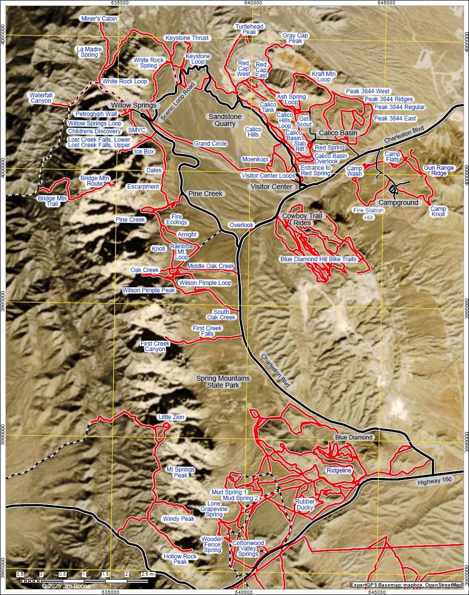 |
| Arnight, Ash Spring Loop, Birdspring Mountain, Blue Diamond Hill Bike Trails, Bridge Mountain Trail, Bridge Mountain Route, Brownstone Tanks, Calico Basin, Calico Basin Overlook, Calico Hills, Calico Hills Loop, Calico Tank, Campground Area Trails, Campground Wash Loop, Campground Flats Loop, Campground Knoll, Cave Canyon, Children's Discovery, Cottonwood Valley Springs Loop, Dales, Escarpment, Entrance to Red Spring, Fire Ecology, Fire Station Hill, First Creek Canyon, First Creek Falls, First Finger, Fossil Canyon, Fossil Trail, Gateway Canyon, Girl Scout Northbound, Girl Scout Southbound, Gray Cap Peak, Grand Circle, Gun Range Ridge Loop, Hollow Rock Peak, Ice Box Canyon, Keystone Loop, Keystone Thrust, Knoll, Kraft Mountain Loop, La Madre Spring, La Madre Miner's Cabin, Little Zion, Lone Grapevine Spring, Lost Creek Falls, Lower, Lost Creek Falls, Upper, Moenkopi Loop, Mountain Spring Peak, Mud Spring No. 1, Mud Spring No. 2, Muffin Rocks, Oak Creek Canyon, Middle Oak Creek, South Oak Creek, Overlook, Peak 3844 East, Peak 3844 Regular, Peak 3844 Ridges, Peak 3844 West, Petroglyph Wall,
Pine Creek Canyon,
Rainbow Mt. Loop,
Red Cap Peak East,
Red Cap Peak West,
Red Spring Boardwalk,
Ridgeline,
Rock Garden,
Slab Rift,
SMYC Trail South, SMYC Trail North, The Park,
To-The-Top,
Turtlehead Peak, Visitor Center Area Loops, Waterfall Canyon, White Rock Loop, White Rock Spring, Willow Springs Loop, Wilson Pimple Loop, Wilson Pimple Peak, Windy Peak, Wooden Fence Spring. |
Note: Map based on true-color aerial photography. North is at the top. Grid is UTM NAD27 CONUS. Roads are black (solid = paved; dashed = unpaved; width implies quality). Trails and routes are red (solid = main; dashed = adjacent or alternate). |
Happy Hiking! All distances, elevations, and other facts are approximate.
 ; Last updated 200211 ; Last updated 200211
|
|