Hiking Around Las Vegas, Red Rock Canyon National Conservation Area

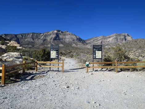 Keystone Thrust trailhead sign (view NW) |
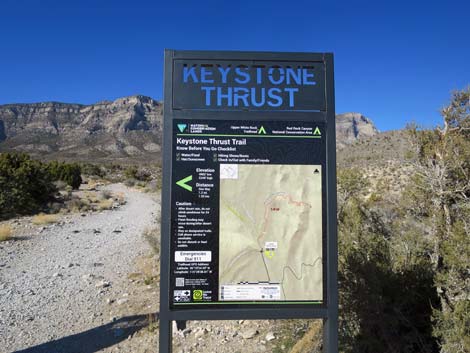
Overview The Keystone Thrust Trail is a moderately strenuous hike that runs out a well-marked trail for 0.8 miles to a place where hikers can easily touch the Keystone Thrust earthquake fault. This fault is interesting because older limestone rocks (gray) were pushed up and over younger sandstone rocks (red). Visitors can see thrust faults in other places around Red Rocks, but this is a good place to actually touch one. This is a good place to take a short hike, marvel in the grand scenery and peacefulness of Red Rock Canyon, and contemplate the forces that once broke the surface of the earth and pushed big blocks of stone about. From the Thrust Fault area, hikers can make a 2-3 miles loop by continuing down the canyon and circling back to the trailhead using the Keystone Loop Trail. Link to map. Link to BLM Georeference PDF map file. |
 Trailhead sign (view NW) |
Watch Out Other than the standard warnings about hiking in the desert, ... this is a pretty safe hike, but if the earthquake fault starts thrusting, be sure to make a run for it. While hiking, please respect the land and the other people out there, and try to Leave No Trace of your passage. Also, even though this hike is short, be sure to bring what you need of the 10 Essentials. Getting to the Trailhead This hike is located along Scenic Loop Road in Red Rock Canyon National Conservation Area, about 45 minutes west of Las Vegas. From town, drive out to Red Rocks, pay the entrance fee, and drive about half-way around the Scenic Loop Road to White Rock Road. Drive up White Rock Road to the White Rock Trailhead. Park here; this is the trailhead. |
 Hiker reading about agave roasting pit (view NW) |
The Hike From the trailhead (Table 1, Waypoint 01), the Keystone Thrust Trail runs north up an old road. Another trail leaves the parking area heading down to the west, so be sure to start on the right trail. Along the Keystone Thrust Trail, notice the diversity of shrub species and scattered conifer trees. This area is located at the interface between the Mojave Desert Scrub habitat type and the Pinyon-Juniper Woodland habitat type. Watch for lots of Banana Yucca, Blackbrush, and Stansbury Cliffrose (typical Mojave Desert Scrub species), plus scattered Single-leaf Pinyon Pine, and Utah Juniper (typical Pinyon-Juniper Woodland species). |
 Trail drops into White Rock Wash (view N) |
A few yards up the Keystone Thrust Trail, hikers pass an agave roasting pit on the left. An agave roasting pit is a cooking pit similar to what is used at a Hawaiian luau where a pit is dug and lined with stones. Wood is piled into the pit and torched. When the fire burns down, the hot rocks retain heat, and food items are placed in the pit and covered over. The meats and vegetables are slow cooked for a day or two. An information sign explains that native peoples used this area as a kitchen, cooking foods such as Utah Agave hearts, desert tortoise, chuckwalla, bighorn sheep, and other tasty items. About 130 yards from the trailhead, the trail crosses White Rock Wash (Wpt. 02) that comes down along the edge of the White Rock Hills. The trail crosses the wash and goes up the other side; it does not go up the wash. At a trail junction (Wpt. 03) about 100 yards past White Rock Wash, the Keystone Thrust Trail turns right and climbs the low hill to the east. Watch for trail signs and a few wooden stairs leading up the hillside. The White Rock Loop Trail continues north (straight) at the trail junction. |
 Trail crosses White Rock Wash (view N) |
The Keystone Thrust Trail runs northeast towards Hogback Ridge until it hits an old road (Wpt. 04) that comes up from the south. The trail turns and follows the old road northward along the steep west side of Hogback Ridge. Following the road north, the trail shortly passes a second agave roasting pit (Wpt. 05) off to the right (east). Beyond the agave roasting pit, the old road winds around, curves to the east, and climbs onto the ridgeline at the north end of Hogback Ridge providing a nice view down into Keystone Basin. A few yards farther, at a trail junction (Wpt. 06) marked by a metal T-post sign with an arrow placard, the Keystone Thrust Trail turns right, leaves the old road, and runs down into Keystone Basin. The old road continues north up the slope towards Keystone Overlook and LaMadre Mountain. |
 Continuing past White Rock Wash (view N) |
From the trail junction (Wpt. 06), the Keystone Thrust Trail runs somewhat steeply down into the canyon and out onto a broad, flat area of red sandstone with manzanita, singleleaf pinyon pine, shrub live oak, Utah agave, blackbrush, and a few other shrubs and grasses growing in the area. This is Keystone Fault Overlook (Wpt. 07). At Keystone Fault Overlook, hikers can look across the wash to the east and see a use-trail running across the hillside near the top of the red sandstone. Just above the solid sandstone, a layer of yellowish soil is a mix of ground up sandstone and limestone. Just above the yellowish layer, limestone outcrops reveal solid rock. Thus, the yellowish layer marks the actual Keystone Thrust Fault. Here, limestone was pushed up over the sandstone, grinding some of the solid sandstone back into sand and mixing it with a bit of ground limestone. It is also interesting to note that much of the sandstone on the surface is broken up into individual stones rather than the slickrock sandstone seen in other areas around Red Rocks, revealing the pulverizing nature of the thrust fault. |
 Approaching trail junction (view N) |
The official trail ends on the broad, flat Keystone Fault Overlook (Wpt. 07), but a use-trail curves back down into the wash and continues out across the hillside on the contour. The use-trail gives a close-up view of the thrust fault (Wpt. 08), then runs out another 0.09 miles onto a nice promontory (Keystone Canyon Overlook; Wpt. 09) with grand views down Keystone Canyon and out across the landscape to the south. On the way down into Keystone Basin, the trail starts by running across old, gray Bonanza King limestone that dates from the Cambrian (about 500 million years ago). At the bottom of the canyon, the trail ends in young, red Aztec Sandstone that only dates from the Jurassic (about 150 million years ago). Generally, you find younger rocks on top of older rocks because rocks generally are built up as new layers form on top of previous layers (i.e., the new rocks need something on which to form; they can't form in the air). However, here older rocks lie atop younger rocks. |
 White Rock -- Keystone trail junction (view N) |
This unusual positioning resulted from plate tectonic (earthquake) activity some 65 million years ago. In this area, tectonic activity compressed the surface of the earth and fractured it into plates. As the compression continued, the plates were pushed (thrust) together horizontally, and some plates slid up and over other plates, putting older rocks on top of younger rocks. Think of this as ice on the surface of a river breaking up during spring where moving water under the ice forces some broken sheets of ice up on top of other sheets of ice. During the 65 million years since this occurred, some of the limestone has completely eroded way, exposing the underlying sandstone. For example, the White Rock Hills formerly were completely covered by limestone. In other places, the limestone has not eroded away, leaving, for example, the La Madre Mountains and Hogback Ridge. |
 Keystone Trail climbs stairs (view E) |
The red sandstone at the end of the Keystone Thrust trail was the surface of the earth some 65 million years ago. It was eventually buried and covered by thrusting limestone, and it has remained covered since then. However, erosion has removed the limestone here and returned the sandstone to its former position on the surface. Enjoy the area, contemplate the forces that produced the current terrain, and then return to the trailhead (Wpt. 01) by following your footprints in the dust back to the trailhead. On the way back down, consider making a bit of a loop at the end of the trail by staying on the old road when the trail cuts off (Wpt. 04). |
 Trail continues up across gentle slope (view NE) |
 Heading towards Hogback Ridge (view NE) |
 Wilderness Area boundary (does not match maps) |
 Trail joins old road (view N) |
 old road (view N) |
 Hiker approaching second agave roasting pit (view N) |
 Agave roasting pit (view from above; SE) |
 Continuing up the trail (view N) |
 Continuing up the trail (view NE) |
 Approaching crest of Hogback Ridge (view NW) |
 Atop crest of Hogback Ridge (view N) |
 Approaching trail junction (view N) |
 Keystone Trail leaves old road (view NE) |
 Old road continues northward (note arrow placard on T-post) |
 Hiker anticipating hiking down into Keystone Basin (view E) |
 View across towards Keystone Thrust (view E) |
 Descending into Keystone Basin (view E) |
 Keystone Basin (note trail across the way; view SE) |
 Trail arriving at Keystone Fault Overlook (view SE) |
 Use-trail continues from Overlook towards Keystone Fault (view NE) |
 Looking towards Keystone Fault (view NE) |
 Use-trail continues past stone cabins into wash (view NE) |
 Stone cabins built in recent years by hikers |
 Hiking up to the Keystone Thrust (view SE) |
 Approaching Keystone Canyon Overlook (view S) |
 Keystone Canyon Overlook (view S) |
Table 1. Hiking Coordinates Based on GPS Data (NAD27; UTM Zone 11S). Download Hiking GPS Waypoints (*.gpx) file.
| Wpt. | Location | UTM Easting | UTM Northing | Elevation (ft) | Point-to-Point Distance (mi) | Cumulative Distance (mi) |
|---|---|---|---|---|---|---|
| 01 | White Rock Trailhead | 637006 | 4004064 | 4,871 | 0.00 | 0.00 |
| 02 | White Rock Wash | 636961 | 4004167 | 4,915 | 0.07 | 0.07 |
| 03 | White Rock - Keystone Jct | 636953 | 4004268 | 4,956 | 0.07 | 0.14 |
| 04 | Old Road Jct | 637055 | 4004381 | 5,009 | 0.11 | 0.25 |
| 05 | Agave Roasting Pit | 637046 | 4004597 | 5,094 | 0.16 | 0.41 |
| 06 | Trail Junction | 637223 | 4004909 | 5,247 | 0.25 | 0.66 |
| 07 | Keystone Fault Overlook | 637383 | 4004874 | 5,135 | 0.12 | 0.78 |
| 08 | Keystone Thrust Fault | 637426 | 4004919 | 5,101 | 0.06 | 0.84 |
| 09 | Keystone Canyon Overlook | 637488 | 4004807 | 5,125 | (0.09) | (0.93) |
| 01 | White Rock Trailhead | 637006 | 4004064 | 4,871 | 0.84 | 1.68 |
Happy Hiking! All distances, elevations, and other facts are approximate.
![]() ; Last updated 240330
; Last updated 240330
| Hiking Around Red Rocks | Hiking Around Las Vegas | Glossary | Copyright, Conditions, Disclaimer | Home |