Hiking Around Las Vegas, Red Rock Canyon National Conservation Area,
La Madre Mountain Wilderness Area
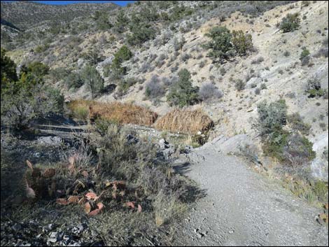 La Madre Creek; end of official trail (view NE) |
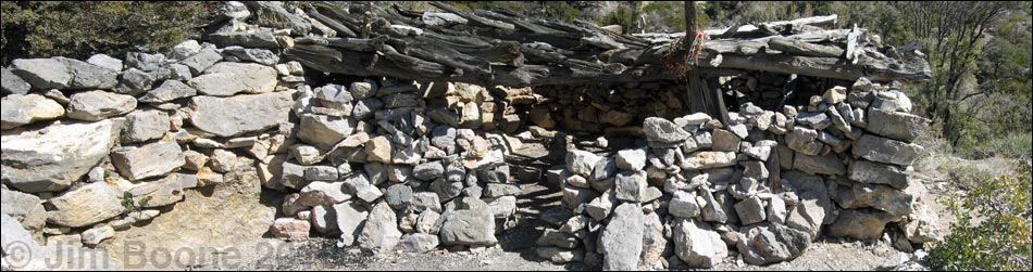
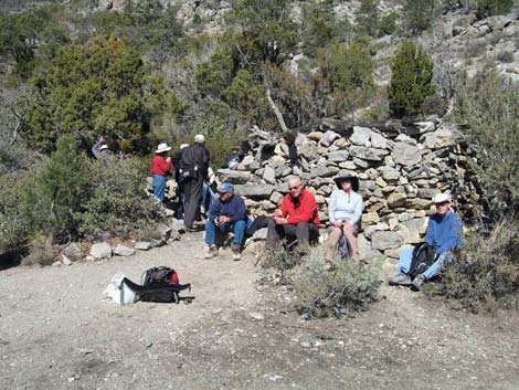
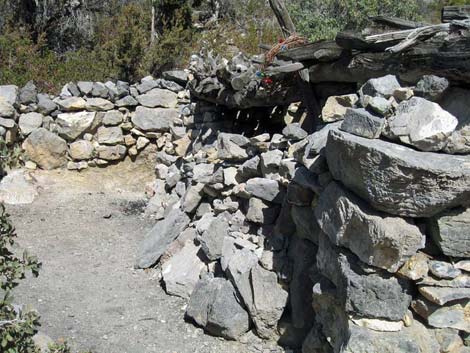
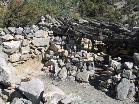
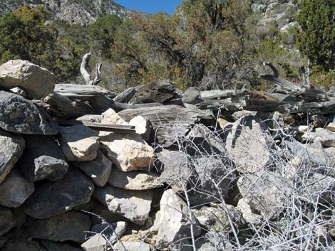
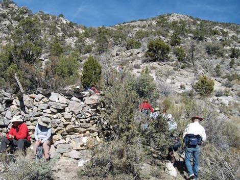
Overview From the pond at the end of the La Madre Spring Trail, this route runs farther into the La Madre Wilderness Area. The moderately difficult route continues steeply up the canyon for 0.6 miles to a stone cabin with a log roof. The use-trail winds back and forth across the creek several times, crashes through lots of bushes, and passes the official La Madre Spring, a 15-foot waterfall, and a couple of scramble-ups. Although maps show a single spring, water actually seeps from many places along the walls of the canyon, providing habitat for lots of marsh vegetation and Baja California Treefrogs. Beyond the cabin, a steep use-trail continues to the mine high on the hillside above. The cabin was originally built by miners, perhaps in the 1920s, but it was later torn down by vandals. The cabin that stands today shows the efforts of people who cared enough to rebuild it. Please take care of this interesting and historic site. Link to map to cabin, map to mine, or elevation profile. |
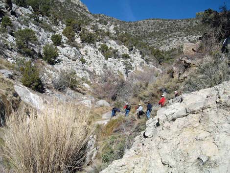
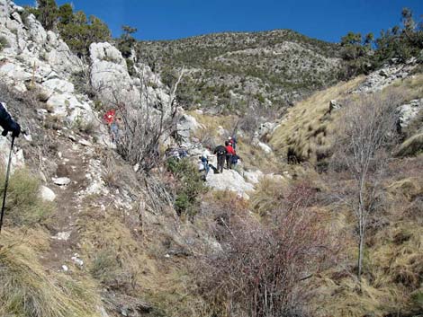
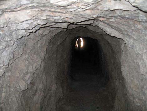
 Use-trail in La Madre Canyon (view N) |
Watch Out Other than the standard warnings about hiking in the desert, ...this is a fairly safe hike, but I wouldn't drink the water. There are a couple of 2nd-class or 3rd-class scramble-ups along the use-trail, one of which is about 15-feet tall, but all are fairly easy when dry; after a rain, the rocks are unusually slick. Just beyond the cabin, there is a mine with one near-vertical shaft and an adit; mines are interesting, but never safe to enter. While hiking, please respect the land and the other people out there, and try to Leave No Trace of your passage. Also, even though this hike is short, the area is remote, so be sure to bring what you need of the 10 Essentials. The cabin was torn down by vandals, and what now stands are the efforts of people who cared enough to rebuild it -- please take care of this historic site. This route is in the La Madre Wilderness Area, so be extra careful of the land. |
 |
Getting to the Trailhead This hike is located along the Scenic Loop Road in Red Rock Canyon National Conservation Area, about 1 hour west of Las Vegas. Drive out to Red Rocks, pay the fee, and then drive about half-way around the Scenic Loop Road to Willow Spring Road. Turn right and drive north 0.6 miles to the Willow Springs Trailhead. Park here; this is the trailhead. For hikers with high-clearance vehicles who want to shorten the hike, continue north on Rocky Gap Road to the La Madre Trailhead. |
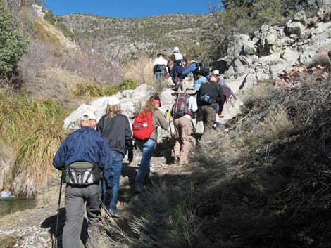 |
The Hike From the end of the pavement at Willow Springs Picnic Area (Table 2, Waypoint 1), the route runs north on Rocky Gap Road for 0.5 miles (Wpt 2). About 100 yards past where the road crosses Red Rock Wash (Wpt 3), the route leaves the road and turns northeast into the La Madre Wilderness Area on the La Madre Spring-White Rock Loop Trail. Follow the La Madre Spring Trail to La Madre Creek (Wpt 13) at the end of the trail. From La Madre Creek, a narrow use-trail continues up the brushy canyon, crossing back and forth over the creek several times. Throughout the canyon, the creek is full of wiregrass, bulrush (some of which is 6-feet-tall), and other "marsh" vegetation, and because of the water, there are many "desert" shrubs along the edges. The vegetation on the rocky hillsides is similar to that below the dam: singleleaf pinyon pine and Utah juniper trees, plus shrub live oak, prickly pear, bunch grasses, banana yucca, blackbrush, and manzanita. |
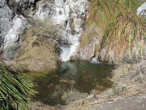 |
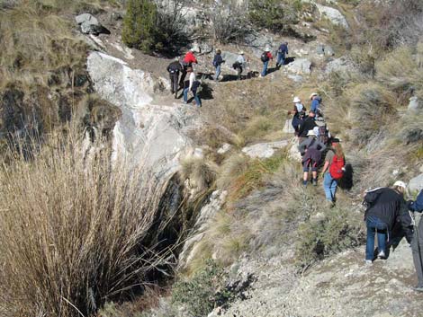
About 0.29 miles above the dam, the use-trail passes the official La Madre Spring (Wpt 14). To my eye, there was no change in the streamflow at this point, and in fact, there is a nice, 15-foot waterfall (Wpt 15) just above this point behind a large clump of common reed. There are a couple of little scramble-ups in this area; the tallest is about 15-feet high, but all are easy. From the spring, the use-trail continues along the bottom of the canyon for another 0.17 miles (Wpt 16). The trail then abruptly turns out of the creek bottom and climbs steeply up the hillside for about 0.07 miles to the top of the streambank (Wpt 17). After another 0.07 miles of hiking up more gentle terrain, the trail arrives at the stone miner's cabin (Wpt 18). From the cabin (Wpt. 18), one use-trail continues up the canyon for another 0.07 miles to the northeast, but it ends unceremoniously in the bottom of the canyon amid mud, shrubs, and little cliffs. |
 |
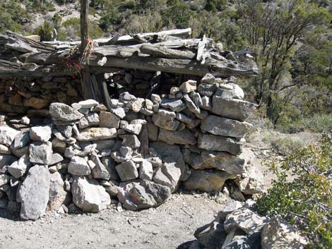
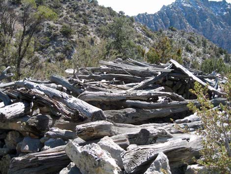
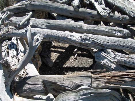
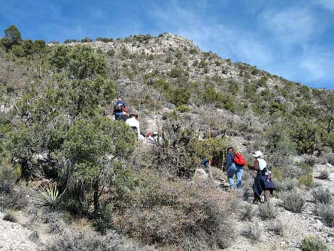
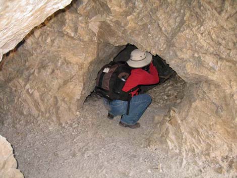
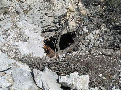
Also from the cabin (Wpt. 18), a narrow use-trail winds up the hillside through trees directly above the cabin heading northwest to the mine. The use-trail winds up between rocks and behind trees, but eventually becomes a well-defined use-trail. At about 0.16 miles beyond the cabin, the use-trail passes what looks like the entrance to a cave (Wpt. 19). Just above there, at about 0.20 miles above the cabin, the use-trail arrives at the mine (Wpt. 20). Don't let the 0.2-mile distance fool you - it takes some tough hiking to get to the mine. There are actually two mines. The trail naturally runs onto the tailings pile of an adit, and there is a near-vertical shaft just above and west of the adit that is easy to miss because of the way the use-trail enters the area. The adit runs straight back into the rocky hillside and was blasted from solid limestone rock. Just inside the mine, there is a shallow pit that is bridged with an old board. Across the pit, there is a cross-drift. From the cross drift, it takes 35 steps into the inky darkness to hit the back of the mine. I walked all the way in without hitting my head, so the adit is fairly tall. There is no shoring inside the mine. |
 |
Back at the cross-drift, facing into the mine, the drift to the left runs 4-5 steps and ends. In the other direction, the drift is a low opening near the floor that opens into a larger area. From there, the drift forks, with one short branch running up and out, and the other running down, winding around, and out. The main adit and west drift seem about as safe as they come, but the east side drift looks a bit spooky. Back out on the tailings pile from adit, the tailings from the upper mine can be seen above to the west. After climbing the side of the steep tailings pile, the near-vertical shaft can be seen against the rock cliff. Someone apparently thought the entrance was unsafe, so they tossed a dead pinyon pine into the opening. Looking through the branches, the shaft does look like it would be hard to climb out. I didn't go in. Return to the trailhead by retracing your path. |
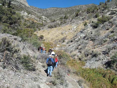
 Hikers continuing up the canyon (view N) |
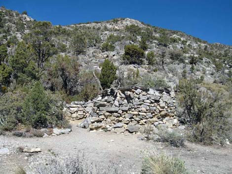 La Madre Miner's Cabin (view N) |
 |
 |
 |
 |
 |
 |
 |
 |
Continuing to the Mine
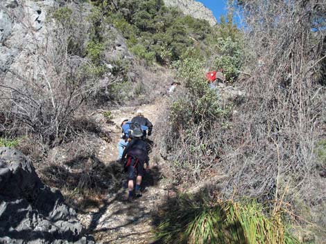
 Hikers departing the cabin heading uphill (view N) |
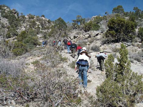 Just above cabin, hiking to mine (view N) |
|
 |
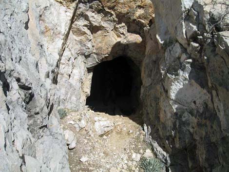 Entrance to the mine adit (view N) |
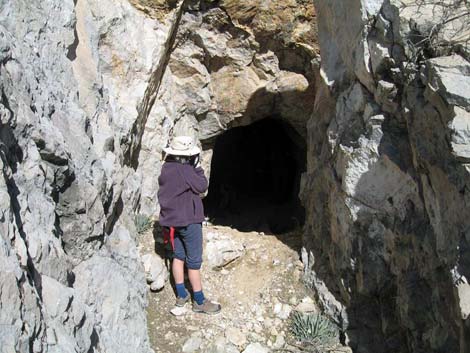 Entrance to the mine adit (view N with adult human for scale) |
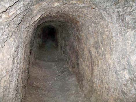 Inside the mine looking in |
 Inside the mine looking out |
 Side chamber to near-vertical shaft |
 Entrance to near-vertical mine shaft (view N) |
Table 2. Hiking Coordinates based on GPS Data (NAD27; UTM Zone 11S). Download Hiking GPS Waypoints (*.gpx) file.
| Wpt. | Location | Easting | Northing | Elevation (ft) | Point-to-Point Distance | Cumulative Distance |
|---|---|---|---|---|---|---|
| 01 | End of Pavement | 635112 | 4002653 | 4,568 | 0.00 | 0.00 |
| 02 | Red Rock Wash | 634408 | 4003038 | 4,701 | 0.53 | 0.53 |
| 03 | Trail Leaves Road | 634312 | 4003150 | 4,744 | 0.09 | 0.62 |
| 13 | La Madre Dam | 634615 | 4004857 | 5,245 | 1.17 | 1.79 |
| 14 | Spring on USGS Topo Map | 634389 | 4005146 | 5,439 | 0.26 | 2.05 |
| 15 | 15-foot Waterfall | 634362 | 4005177 | 5,471 | 0.03 | 2.08 |
| 16 | Bottom of Ridge | 634333 | 4005338 | 5,575 | 0.11 | 2.19 |
| 17 | Top of Ridge | 634319 | 4005428 | 5,661 | 0.06 | 2.25 |
| 18 | Miner's Cabin | 634309 | 4005516 | 5,693 | 0.06 | 2.31 |
| 19 | Cave | 634174 | 4005675 | 6,032 | 0.16 | 2.47 |
| 20 | Mine | 634169 | 4005738 | 6,109 | 0.04 | 2.51 |
Happy Hiking! All distances, elevations, and other facts are approximate.
![]() ; Last updated 240330
; Last updated 240330
| Hiking Around Red Rocks | Hiking Around Las Vegas | Glossary | Copyright, Conditions, Disclaimer | Home |