Southern Nevada Wilderness Areas
 |
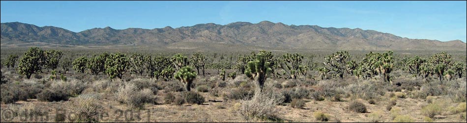
Overview South McCullough is a fairly large (44,252 acres) wilderness area that includes most of the southern part of the north-south trending McCullough Range and the large bajada to the southwest. The Southern McCullough Mountains are formed of 1.7-billion-year-old metamorphic rock, with a bit of more recent volcanic rock in the northern part of the wilderness area. The peaks and ridges look softer and more rounded than many peaks in southern Nevada, but they are still quite rocky, rugged, and exceed 7,000 feet in height. The base of the mountains is at about 3,300 feet on the west side and 4,500 feet on the east side. Springs in the wilderness area provide water for wildlife and early human inhabitants. Link to map of the wilderness area. |
 |
Despite the proximity to Las Vegas, the South McCullough Wilderness Area is a wild and rugged place with few signs of human use except for cattle that still roam the area. The difficulty of getting to the wilderness area adds to the feeling of isolation, providing a true wilderness experience for hikers. Even visiting the edge of the wilderness area (e.g., Pipe Spring) provides a great introduction to this wonderful and wild place. A hike up McCullough Mountain (7,026 ft), into the heart of the wilderness area, provides a great introduction to the area. Although the northern and southern ends of the McCullough Range are named as a single mountain range, the two ends differ and are not one geologic feature. The northern end of the McCullough Range (North McCullough Wilderness Area) was formed from recent volcanic activity, while the southern end (South McCullough Wilderness Area) is a ridge of ancient metamorphic rock. If you hike in wilderness areas, help protect them by learning about and reporting noxious and invasive weeds. |
 East side access (Pine Spring Road) |
Location The wilderness area is located approximately 45 air-miles south of Las Vegas, between Interstate-15 and Highway 95, and north of Highway 164. It is about 15 miles northwest of Searchlight. Boundaries The boundaries of this wilderness area are complex, but essentially, they include all of the high elevation land surrounding South McCullough Mountain. The northern boundary is marked by a powerline road that runs over McCullough Pass. The southern boundary is not marked, but it follows canyons on the east and west sides of the range (the canyons just south of Pine Spring Canyon). The western boundary extends out from the base of the mountains to follow a wash in the valley between the McCullough Range and the Lucy Gray Range. The eastern boundary basically follows the contour of the mountains at the top of the bajada. |
 West side access |
Access is from dirt roads on the southeast, west, and northern sides of the wilderness area. The southeast side of the wilderness area can be accessed from Searchlight via Pine Spring Road. The road is marginally accessible in a 2WD, high-clearance vehicle when the road is dry, but a 4WD vehicle would be safer. Access from the west is via roads the Jean Dry Lake area. |
 |
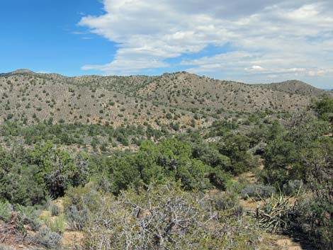
Terrain The Southern McCullough Range is a north-south orientated, ridge of rugged old metamorphic rock deeply cut by canyons on the east and west sides. North of McCullough Mountain (7,026 ft), fault-influenced valleys run north-south, parallel to the crest of the range, creating a jumble of peaks and valleys. The wilderness area includes a wide bajada on the west side of the mountains. While the overall structure of the mountain range is a north-south ridge with canyons cutting east and west from the crest, the detail of the terrain is quite complex. Ridges and canyons run in all directions; for example, one canyon on the west side of the range begins by running east, then curves to the south before turning and running west and out onto the bajada. The rounded ridgetops and winding canyons make this a challenging area for route finding. |
 Nature art |
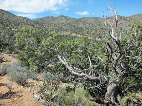
Habitat Types The lower elevations are dominated by Mojave Desert Scrub (Upper Sonoran Life Zone), where Creosote Bush, Mojave Yucca, Banana Yucca, Buckhorn Cholla, and low-growing shrubs are common. Scattered Honey Mesquite occur in washes, as do more common Catclaw Acacia and Apache Plume. The middle elevations are also Mojave Desert Scrub (Upper Sonoran Life Zone), but the vegetation is dominated by blackbrush, Joshua trees, buckhorn cholla, Mojave yucca, and banana yucca. The higher elevations are dominated by a Pinyon-Juniper Woodland (Upper Sonoran Life Zone), where singleleaf pinyon pine, Utah juniper, various cholla, pricklypear, and hedgehog cactus species, banana yucca, and a variety of knee-high shrubs are common. On the peaks, California juniper replace Utah juniper. |
 Sunset from atop McCullough Mountain |
Wildlife Mammals include desert bighorn sheep, mule deer, black-tailed jackrabbits, desert cottontail rabbit, White-tailed Antelope Squirrel, desert woodrats, and feral cows. Reptiles include desert tortoise at the lower elevations, Western Fence Lizards, Side-blotched Lizards, and a variety of other lizards and snakes. Birds include Gambel's quail, Chukar, Juniper Titmouse, Spotted Towhee, Bushtits, Red-tailed Hawks, Common Raven, Golden Eagle, Northern Flicker, Black-throated Sparrows, Chipping Sparrow, White-crowned Sparrow, Crissal Thrasher, and other songbirds. Archaeology No specific information, but locals report petroglyphs near Pine Spring. I looked, but not see any rock art. Ranchers historically used the area, leaving feral cows, corrals (e.g., Pine Spring Corral), old cabins (Railroad Spring), and water developments as evidence of their passage. |
 Banded metamorphic rock |
Geology The South McCullough Mountains are formed primarily of 1.7-billion-year-old foliated metamorphic rocks, the second oldest rocks in Nevada. Most of the ridges have weathered to a gently rounded tops with steep sides, but rocky outcrops of layered metamorphic rock and quartzite are common. Near the crest of the range, the ridges themselves are steep, even though they retain broad, gently rounded crests. The wilderness area has been influenced by volcanic activity to the north. Faults north of McCullough Mountain (7,026 ft) run north-south and parallel to the crest of the range, creating deep canyons that run north-south before turning and flowing out onto the bajada. The bajada on the west side of the range is formed on old alluvial deposits, which is in contrast to the Quaternary alluvial deposits found in most of southern Nevada. The ridges are steep and rocky, but rounded, and the washes are deep, sandy, and run at more gentle grades than are found in the limestone mountains around southern Nevada. |
 Illegal off-road vehicle use |
Threats As of 2016, cattle still roam these mountains, including the highest ridges and peaks, and their grazing and bedding activities disturb large areas of soil on many of the ridges. Cattle trails can be found on many ridges, some sidehills, and in washes. Off-road vehicles penetrate far up the sandy washes on the east and west sides of the range. |
 Pine Spring Area |
 Pine Spring Area |
 Ancient juniper trees |
 Dry western slopes waiting for monsoon rains |
Note: All distances, elevations, and other facts are approximate.
![]() ; Last updated 190905
; Last updated 190905
| Wilderness Areas | Hiking | Guide Services | Glossary | Copyright, Conditions, Disclaimer | Home |