Southern Nevada Wilderness Areas
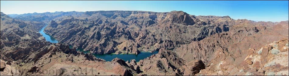
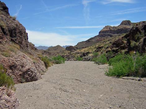
 Boy Scout Canyon at the Colorado River (view NE) |
Overview Black Canyon is a medium-sized (17,220 acres) wilderness area with distinctly different landscapes on the west and east sides. The west side has gently rolling hills formed by the flow and erosion of basalt; while the east side has steep volcanic cliffs cut by deep canyons. The entire landscape is densely covered with desert-varnished volcanic boulders and very sparsely covered by vegetation. Elevations are relatively low, ranging only from about 600 to 3,000 feet. Bighorn sheep and desert tortoise are fairly common. Springs, some of which are hot, and the Colorado River provide water for wildlife. Archeological and mining artifacts can be found in the area. The Black Canyon Wilderness Area is separated from the El Dorado Wilderness Area by a powerline corridor. Combined, these two wilderness areas are fairly large, nearly 50,000 acres, and both are almost entirely contained within the boundaries of Lake Mead National Recreation Area. If you hike in wilderness areas, help protect them by learning about and reporting noxious and invasive weeds. |
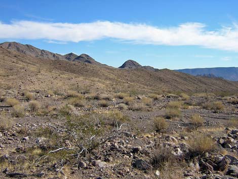
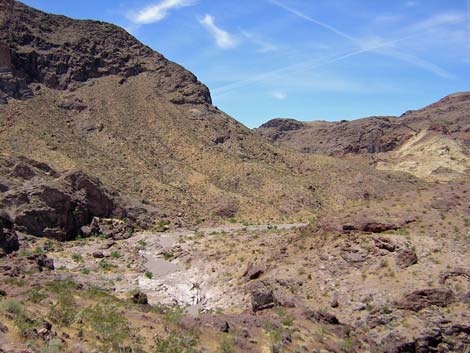
 Gently sloping bajadas and hills on W side of wilderness area (view N) |
Location The Black Canyon Wilderness Area is located about 25 air-miles southeast of Las Vegas, between Boulder City and the Colorado River. Link to map of the Black Canyon Wilderness Area. Boundaries The western boundary generally is coincident with the boundary of Lake Mead National Recreation Area. The northern boundary starts along a dirt road, then runs east on section lines to the Colorado River. The eastern boundary is the river. The southern boundary is a powerline corridor that follows Burro Wash, this is also the northern boundary of the El Dorado wilderness area. |
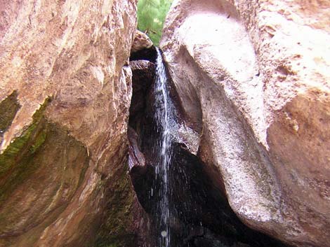 Hot waterfall below a hot spring in Boy Scout Canyon (view W) |
Access The wilderness area can be accessed from dirt roads that run along the west and south sides of the area, and also from the river on the east. On the south side, the Burro Wash Road runs along a powerline corridor, and (assuming dry roads) driving to the crest of the mountains only requires a high-clearance, 2-WD vehicle. Several roads penetrate the western side of the wilderness area. |
 Sparse and stunted vegetation (view E) |
--Burro Wash Road To get to Burro Wash from Boulder City, turn south at the intersection of Highway 93 and Buchanan Blvd. Buchanan intersects Highway 93 at the stoplight where Highway 93 jogs north in downtown Boulder City (driving east, if you turn left at the stoplight, you will go to Hoover Dam; but if you turn right, you will be on Buchanan). From Highway 93, drive south on Buchanan for 2.9 miles to a paved road (no street name) just before a large power substation. Turn east (left) on the paved road and drive for 0.5 miles to the north entrance gate of the power substation. At the gate, continue east on the dirt road that runs parallel to the chain-link fence. Beyond the substation fence, curve southeast on a wide, graded dirt road that follows a line of high-tension powerlines running out towards a saddle on the mountains to the southeast. The road passes under other high-tension powerlines. Drive 1.8 miles across the flats to the edge of the hills, which is also the edge of Lake Mead National Recreation Area (marked with fencing and signs). Continue southeast for another 4.3 miles on a graded, but rocky road to an overlook at the head of Burro Wash. At this point, which is the end of the easy 2-WD road, there is a parking area and a great view east into Arizona. At this point, you first encounter the boundary of the wilderness area. |
 |
From the overlook, you can drive to the river in a 2-WD vehicle, but it would be hard, if not impossible, to get back out; and the worst spot is near the end of the road. From the overlook, the road runs steeply down rocky switchbacks to the bottom of the canyon (Burro Wash). At a fork in the bottom of the canyon, stay left and stay in the bottom of the wash. The road continues down the wash as a fairly good gravel road, but there are a few large rocks and some deep, loose gravel. From the overlook, it is 4.8 miles to the end of the road in the canyon (blocked by water-polished narrows). Just before the narrows, the main road cuts up and out of the canyon on the south side of the wash. The road runs up to a saddle and forks. The main road stays right and runs steeply down the other side of the saddle into a ravine. There is a rough section down this road that requires 4WD to get back up on the way out. If you drive down to look at the rough spot, it will be hard to back out if you decide not to do it. From the wash before crossing the saddle, it is about 1.5 miles to the river, so it is about 1 mile to the river from the saddle. The last bit of road runs down a narrow, rocky canyon, and a spring in a side canyon puts water on a short section of road. |
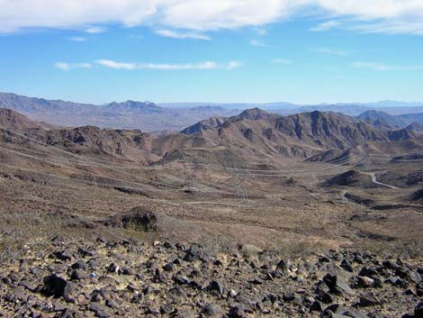 Wilderness area (view E from the saddle at the top of Burro Wash) |
--Boy Scout Canyon Road Boy Scout Canyon Road starts at the end of Utah Street in Boulder City. From downtown Boulder City, drive southeast on Utah Street out past the cemetery on the edge of town. Utah Street ends at a garbage transfer station. Just outside the transfer station fence, a wide, graded dirt road forks off to the right (south). Watch for and follow signs towards the Boulder Rifle Pistol Club, Courtesy Range. Turn right onto the dirt road and drive southeast for about 0.85 miles to an intersection of dirt roads under the last set of high-tension power lines. At this intersection, the road to the gun club turns left, but the road to Boy Scout Canyon continues straight. Continue east for another 0.45 miles (along a ridgetop overlooking the gun range) to a turnoff to the left (north). Turn left on the curve and drive down a fairly steep road through a gap in the ridge to the valley below. The road follows the gun club fence around for 0.7 miles to the Lake Mead boundary, which is marked with large signs and fencing on both sides of the road to discourage off-road driving. Because of soft sand, 2WD vehicles should drive no farther than 0.3 miles past the boundary, but the road continues for a total of 2.0 miles past the boundary. |
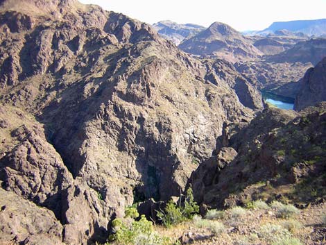
 Canyon near the Colorado River (view W) |
Terrain The El Dorado Mountain Range forms the backbone of the wilderness area, and the two side of the mountains have different landscapes. On the west side of the wilderness area, the landscape is gently rolling hills formed from the flow and erosion of basalt and volcanic ash. These hills slope gently up to the crest of the mountains. The hillsides are strewn with reddish brown boulders that are covered with an astounding amount of black desert varnish. The rocks are so smooth that when the sun reflects off the desert varnish, it looks like thousands of shards of broken glass scattered across the hillside. From the crest of the mountains east to the Colorado River, the terrain is a rugged maze of volcanic peaks, steep cliffs, deep canyons, and vertical cliffs that tower above the river. The hillsides are strewn with reddish brown, highly varnished boulders. Near the river, the hills are formed from old metamorphic rocks with steep cliffs and narrow, water-polished canyons. Much of the land bordering the river is cliffy, but there are small beaches where side canyons empty into the river. Burro Wash, on the south edge of the wilderness area, is a deep, wide wash. |
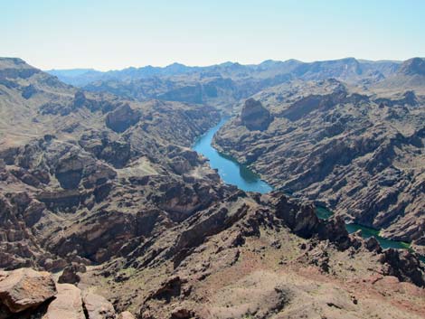
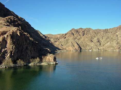 Colorado River at the SE corner of the wilderness area (view N) |
Habitat Type In general, the vegetation is Mojave Desert Scrub dominated by creosote bush, white bursage, a few other low-desert shrubs, and a variety of cacti. West of the crest, the vegetation on the flats and hillsides is sparse, stunted creosote and white bursage, with little else except exotic brome grass. There are a few other shrub species mixed in, such as buckwheat and Encelia, plus a few cacti (prickly pear and cholla) scattered about, but the diversity is low and there is none of the buckhorn cholla or teddybear cholla found south of here. The vegetation in the shallow drainages is more robust and diverse. East of the crest, the vegetation on the steep, rocky hillsides is sparse, stunted creosote with little else in most places except brome grass. Along the washes, the species diversity is higher, and species such as catclaw acacia and Encelia are common. Saltcedar is common along the river. This country is very dry and gets very little rain. |
 Catclaw acacia along Boy Scout Wash (view E) |
The vegetation in Burro Wash is dense and diverse compared to the hillsides, but it still is sparse compared to other places in the Mojave Desert. The wash vegetation is dominated by creosote bush and snake broomweed, with an occasional catclaw acacia and a limited variety of other low-growing shrubs. We found one candelabra-type desert milkweed in the wash, and several specimens of vine-type milkweeds. On the rocky hillsides just above the wash, there is a fair bit of creosote and Encelia in some places, but mostly it is stunted creosote and brome grass, plus a few barrel cactus among the rocks. In the lower wash and along the river, the taller shrubs include honey mesquite, catclaw acacia with mistletoe, desert willow, and saltcedar. There is also a fair bit of creosote, snake broomweed, Encelia, ephedra, and some prickly pear. The rocky hillsides and cliffs have a bit of Schott's Pygmycedar, creosote bush, Encelia, and barrel cactus. |
 Sandy wash and sparsely vegetated slopes (view W) |
Wildlife Desert bighorn are common, and their trails can be seen on some hillsides. Other mammals include wild burros, Townsend's big-eared bat, bobcats, mountain lion, coyotes, and black-tailed jackrabbits. Birds of the desert include Peregrine Falcon, Red-tailed Hawk, Gambel's quail, Rock Wren, Canyon wrens, and Phainopepla. Along the river, ducks, American coots, Common Loons, Double-crested Cormorants, Black Phoebe, and many species of migrants can be found. Reptiles include banded geckos, collared lizards, side-blotched lizards, desert spiny lizards, tree lizards, zebra-tail lizards, chuckwalla, and rattlesnakes. There are about 2,700 acres of desert tortoise habitat in the wilderness area. Relict leopard frogs are thought to occur here, and Red-spotted Toads are common in wet canyons. |
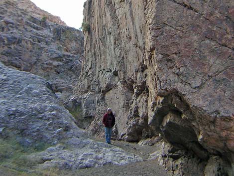
 Cliffs and canyons (view NW) |
Archaeology Resources are said to include petroglyphs, lithic scatters, and an intaglio, but I have no personal knowledge of these sites. The general area has been occupied by native peoples for thousands of years. |
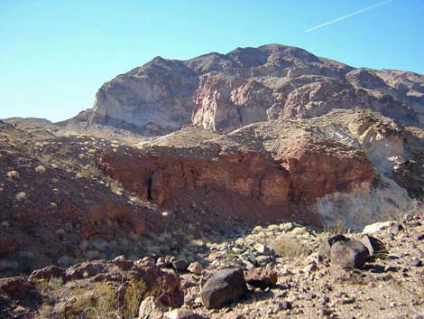
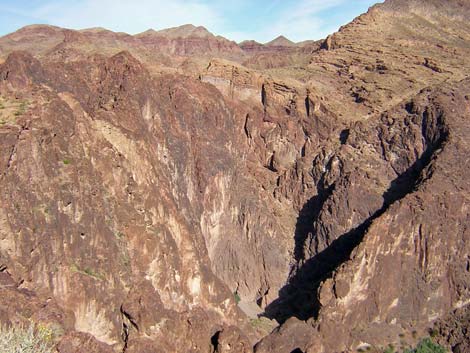
 Black Canyon (view S) |
Geology The El Dorado Mountains primarily are Precambrian metamorphic rocks with intrusions that are about 1.4 billion years old. These old rocks are overlain by colorful (red, white, and brown) Tertiary volcanic tuffs, ash, pyroclastic flows, and basalt flows, mostly of Oligocene and Miocene age (40-20 million years old). The El Dorado Mountains were uplifted during the Miocene Basin and Range Uplift, about 15 million years ago. This is volcanic country, and Black Canyon gets its name from the black, volcanic rocks in the area. |
Note: All distances, elevations, and other facts are approximate.
![]() ; Last updated 240729
; Last updated 240729
| Wilderness Areas | Hiking | Guide Services | Glossary | Copyright, Conditions, Disclaimer | Home |