Hiking Around Las Vegas, Grand Canyon National Park
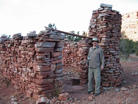 Remains of the stone building (view N) |
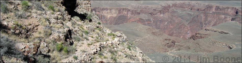
Overview The Trail-of-the-Caves Trail is one of three routes that lead down off Horseshoe Mesa to the Tonto East Trail. I've hiked all three trails (the others are the Page Spring Trail and Cottonwood Canyon Trail), and this is the easiest of the three. While this one is more of a grind, it also looks safer and easier than the other two. From the stone building at the end of the Grandview Trail atop Horseshoe Mesa, the Trail-of-the-Caves Trail runs north along the west edge of Horseshoe Mesa, then switchbacks down the inside of the west arm of the horseshoe to connect with the Tonto East Trail. The views from the end of Horseshoe Mesa are spectacular. Link to trail map or elevation profile. |
 Trail on edge of Horseshoe Mesa (view N) |
Watch Out Other than the standard warnings about hiking in the desert, ...this trail runs along steep hillsides with precipitous drop-offs, and while not a dangerous trail when dry, falls from many places would be fatal. This trail would be treacherous during winter if snow or ice were present. While hiking, please respect the land and the other people out there, and try to Leave No Trace of your passage. Also, this is a long hike, so be sure to bring the 10 Essentials. |
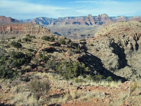
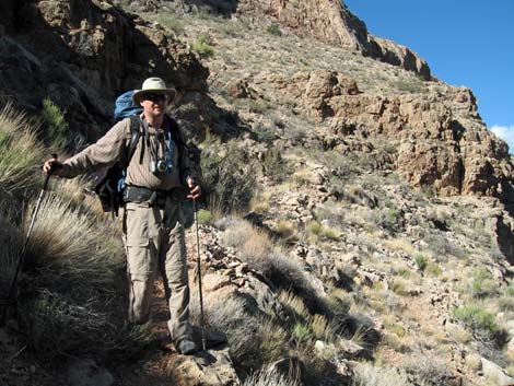
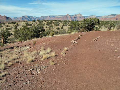 Trail to the Cave of the Domes starts here (view N) |
Getting to the Trailhead
This hike is located on the South Rim of the Grand Canyon, about 5 hours southeast of Las Vegas. From Las Vegas, drive out to the South Rim of Grand Canyon National Park. From the South Rim Visitor Center (Table 1, Site 811), drive east on South Entrance Road (Hwy 180) to Highway 64 (Site 951), the road to Desert View. Turn left towards Desert View and drive east for about 12 miles to the Grandview Point turnoff (Site 952). Turn left onto the Grandview Point access road and drive north to the parking area at the end of the road (Site 953). Park here; this is the trailhead. |
 Junction of trail and use-trail (view NW) |
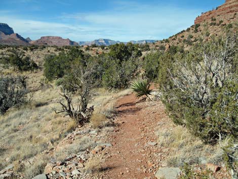
The Hike From the trailhead on the South Rim (Site 953), the route follows the Grandview Trail for 3.0 miles to Horseshoe Mesa (Table 2, Wpt. 1), which is the top of the Redwall Limestone and about half-way down to the Colorado River. The trail begins in the Transition (Yellow Pine Forest) Life Zone where the forest is dominated by Ponderosa Pine. Just over the edge of the rim, the trail begins into the Upper Sonoran (Pinyon-Juniper Woodland) Life Zone where the forest is dominated by Two-needle Pinyon Pine and Utah Juniper, with a few Douglas Fir to keep things interesting. The top of Horseshoe Mesa is still in the Upper Sonoran (Pinyon-Juniper Woodland) Life Zone, but the vegetation is dominated by a low-growing forest of Utah Juniper with the distinct flavor of the Mojave Desert (Mojave Desert Scrub). For details of getting down to Horseshoe Mesa, see the Grandview Trail. |
 Trail goes down this gully (view NE) |
The Grandview Trail ends on Horseshoe Mesa at the old stone building (Wpt. 1) that served as the cookhouse for the Last Chance Mine, a copper mining operation that started during the 1890s. All that remains of the building are the walls, chimney, an old cooking pot, some stove pipes, and a few bits of junk. Several mine shafts, some mining equipment, old rusty cans, and other artifacts can be found in the area. Please help protect this historical area by not damaging or removing the things that remain. It is never safe to enter old mines. From the old stone building (Wpt. 11), the Trail-of-the-Caves Trail continues north along the west edge of Horseshoe Mesa. About 100 yards north of the old stone building, the trail passes an unmarked junction (Wpt. 2) with a trail that bends to the northeast and runs out to the large-group campsites. |
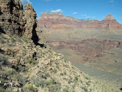
 Trail in gully (view S from tip of Horseshoe Mesa) |
Staying to the left at the trail junction (Wpt. 2), the Trail-of-the-Caves Trail continues north along the west side of Horseshoe Mesa, between the edge of the cliffs and the hill that sits atop the mesa. Out at the northwest toe of the hill, the trail crosses some unvegetated red-dirt areas, then bends to the northeast and contours down at a moderate grade into the head of the shallow ravine (Wpt. 4). The route to the Cave of the Domes leaves the main trail here and runs west down the ravine. Continuing north, the trail climbs out of the gully and runs out across rocky flats with lots of low-growing Utah Juniper. Eventually the trail drifts towards the western edge of the mesa. The trail runs down across west-facing slopes, then runs onto a ridgeline overlooking the narrow western arm of Horseshoe Mesa. Just below that point, the Trail-of-the-Caves Trail reaches a junction (Wpt. 5) with a use-trail that runs out to the northwestern tip of Horseshoe Mesa. |
 Trail on hillside (view SE from tip of Horseshoe Mesa) |
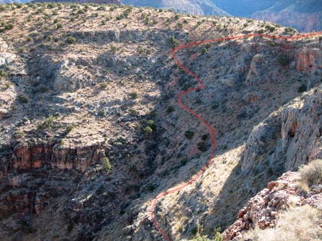
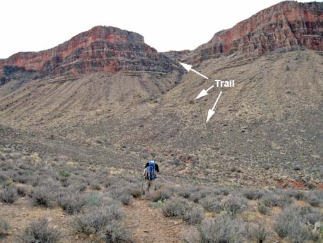
The trails here are a bit confusing, probably because of the several use-trails, and unfortunately the use-trail to the tip of Horseshoe Mesa looks like the main trail, while the trail that starts down over the edge looks like a use-trail. Shortly after starting over the edge (perhaps 30 vertical feet), the "use-trail" intersects what is obviously the main trail, and the Trail-of-the-Caves Trail begins dropping through the Redwall. Through here, the Trail-of-the-Caves Trail is a fine, if a bit steep, hiking trail. Much of it is narrow and rocky, and some is built up with rocks along the edge, but except for tripping off the edge, the trail generally is safe. From the top of Horseshoe Mesa, the trail switchbacks quickly down the gully, then cuts north along the inside of the horseshoe. At the base of the Redwall, the trail switchbacks steeply down the hillside until it hits the wash at the bottom of the gully, then turns and goes essentially straight down the hillside. At the bottom of the hillside, the trail turns into a watercourse gully, but there are cairns to follow through the area. |
 |
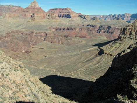
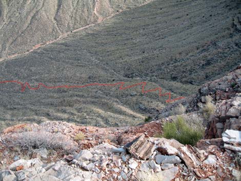
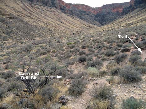
In what will seem like way out on the flats, the Trail-of-the-Caves Trail ends at a junction with the Tonto East Trail (Wpt. 6), which is marked with an enormous cairn with an old drill bit sticking out the top. If the weather were hot, I would wait for the evening shadows to descend on the trail before climbing onto Horseshoe Mesa. After leaving the top of Horseshoe Mesa, the vegetation changes to a Mojave Desert Scrub environment dominated by low-growing shrubs, cactus, and bunchgrasses. At the trail junction, the shrubs are mostly Blackbrush and Nevada Jointfir with some Agave, Soaptree Yucca, and Banana Yucca. The cactus are represented by two species of pricklypear: one with large pads and one with small pads, and there is a forest of tree-sized Catclaw Acacia in the wash just east of the trail junction. |
 Trail traverses below cliffs (view NE) |
 Bits of the trail can be seen ahead (view SW from Tonto East Trail) |
 Tonto East Trail junction (view S between arms of the horseshoe) |
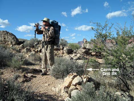 Drill bit and cairn mark trail junction (view W) |
Table 1. Highway Coordinates (NAD27, UTM Zone 12S). NOTE: This is UTM Zone 12. Download Highway GPS Waypoints (*.gpx) file.
| Site # | Location | Latitude (°N) | Longitude (°W) | UTM Easting | UTM Northing | Elevation (feet) | Verified |
|---|---|---|---|---|---|---|---|
| 811 | Visitor Center, Canyon View Information Plaza | 36.0590 | 112.1085 | 400166 | 3990857 | 7,092 | Yes |
| 951 | Highway 180 at Highway 64 | 36.0519 | 112.1049 | 400477 | 3990072 | 7,104 | Yes |
| 952 | Highway 64 at Grandview Access Road | 35.9895 | 111.9920 | 410581 | 3983037 | 7,489 | Yes |
| 953 | Grandview Point parking area | 35.9979 | 111.9870 | 411039 | 3983967 | 7,418 | Yes |
Table 2. Hiking Coordinates (Waypoints; NAD27; UTM Zone 12S). Download Hiking GPS Waypoints (*.gpx) file.
| Wpt. | Location | Easting | Northing | Elevation (ft) |
|---|---|---|---|---|
| 01 | Stone building | 412122 | 3986440 | 4,865 |
| 02 | Trail to group campsites | 412122 | 3986542 | 4,895 |
| 04 | Trail to Cave of the Domes | 411755 | 3987202 | 4,872 |
| 05 | Edge of Horseshoe Mesa | 411528 | 3987659 | 4,832 |
| 06 | Tonto Trail junction | 411978 | 3988252 | 3,912 |
Happy Hiking! All distances, elevations, and other facts are approximate.
![]() ; Last updated 240326
; Last updated 240326
| Hiking the Grand Canyon | Hiking Around Las Vegas | Glossary | Copyright, Conditions, Disclaimer | Home |