Jade Canyon to Ruby Canyon
Hiking Around Las Vegas, Grand Canyon National Park

Overview | Previous Segment | Next Segment
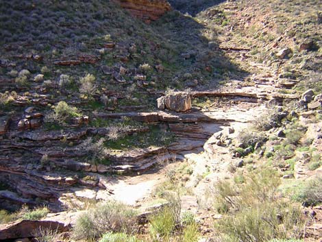 Jade Wash (view SE) |
Overview This description of the Tonto West Trail is divided into two parts: (1) an overview of the entire trail, trailheads, and other general information, and (2) individual canyon-to-canyon segments. From the wash in Jade Canyon, it is about 2.3 miles and 2 hours to the wash in Ruby Canyon. Seasonal water is available in Ruby Wash. This segment of the trail runs east out of Jade Canyon, turns north and runs across the Le Conte Plateau overlooking the Inner Gorge, then turns west and runs back into Ruby Canyon. The trail is always faint, but it is fairly easy to follow most of the way. This segment of trail is in Backcountry Use Zone BP9 (at-large camping). Link to map of this segment. |
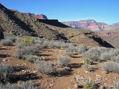 Faint trail along Inner Gorge (view N) |
Watch Out Other than the standard warnings about hiking in the desert, ...be sure to read the Watch Out section on the Tonto West Overview page, which discusses things such as cell phones and signal mirrors. While hiking, please respect the land and the other people out there, and please try to Leave No Trace of your passage. Getting to the Trailhead Trailhead information is presented on the Tonto West Overview page. |
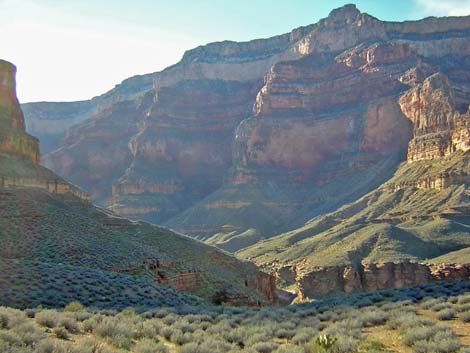 Ruby Canyon (view SW) |
The Hike 16. Jade Canyon to Ruby Canyon -- 2.3 miles and 2 hours The trail from Jade Canyon to Ruby Canyon does not follow the route marked on the USGS topo maps. According to the map, the trail climbs steeply up the hillside to near the Muav Limestone before cutting out of Jade Canyon on the contour. However, the current trail crosses Jade Wash about 100 m east of (below) where it is shown on the map, and it climbs steeply only for a short distance, then cuts out on the contour above the Tapeats Sandstone, closely following the Tapeats all the way around into Ruby Canyon. The old and new trails join far back in Ruby Canyon. |
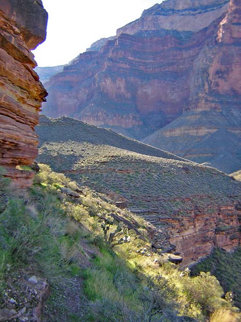 Steep, narrow trail between cliffs (view SW) |
From the slickrock crossing in Jade Wash by the enormous, banded boulder (Table 16, Waypoint 090), the trail climbs steeply up the northern hillside for 1 hard minute to get above the cliffs (watch for a cairn high on the hillside) (Wpt. 091). The trail then turns and runs east on an easy trail following the contour. The trail crosses a ridge between two gullies just above a large thumb of rock, then continues out to the end of the flat, rocky point (Wpt. 092) on the very edge of the cliffs overlooking the Inner Gorge. The views are spectacular. The trail follows the edge of the cliffs around the point and continues along the edge into the next side canyon (Wpt. 093) where a cairn route leads north and straight up the wide, rocky gully. Following the cairns, the trail exits the gully (Wpt. 094) on a bit of trail, then heads north across the flats on a good trail, passing below a big boulder thumb sticking up on the horizon. From there, the trail runs north for about 5 minutes into the next side canyon, crossing the gully high under the cliffs. The trail continues north to a point, crosses the ridge (Wpt. 095), and turns west into Ruby Canyon. There is a small, but spectacular campsite out on the point beyond the trail with a tent site that overlooks the canyon and provides views of Ruby Rapids from the sleeping bag. |
 Ruby Canyon crossing (view W) |
Starting into Ruby Canyon (Wpt. 095), the trail turns west and runs downhill at a moderate grade to the edge of Ruby Canyon where hikers might see water flowing in the wash below. About 10 minutes into Ruby Canyon, the trail crosses the first gully on a rocky hillside that provides spectacular views up Ruby Canyon and down to rapids on the river. The trail works across steep hillsides and several gullies near the edge of the Tapeats with precipitous cliffs below the trail. The trail runs below bands of cliffs in some places. Most of the gullies are crossed on the contour, but the trail gets rougher farther back towards the crossing. At one point, the trail climbs steeply up over a low ridge and down the other side rather than contouring around it. |
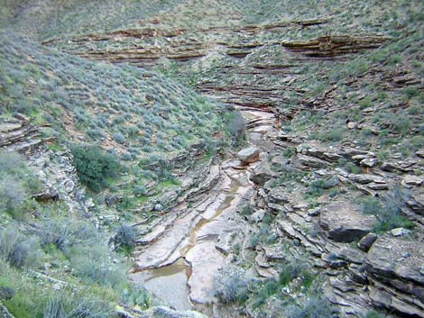
 Ruby Creek (view E) |
The good trail continues along the cliffs, more or less on the contour until near the wash crossing, then it drops fairly steeply to a flat area above the Tapeats with an agave roasting pit and good campsites. From there, two trails cut steeply down the dirt and rock hillside to Ruby Wash at an enormous boulder on the slickrock in the wash (Wpt. 096). The easier trail drops into the wash above the boulder, while the steeper route drops into the wash below the boulder. Hiking west, I lost the trail near the back of the canyon and followed off-route cairns down into the gorge too early, eventually climbing 4th-class cliffs to get back up to the trail. Keep in mind that the crossing is at the enormous boulder in the wash, and that there is no safe way down the cliffs until right above the boulder. Other than the slickrock, there are no campsite opportunities at the crossing, proper. The small stream provides seasonal water. |
Table 16. Hiking Coordinates Based on GPS Data (NAD27; UTM Zone 12). Download Entire Route Waypoint (gpx) file.
| Wpt. | Location | Time | Easting | Northing | Elevation (ft) | Verified |
|---|---|---|---|---|---|---|
| 090 | Jade Wash (61) | 1237 | 381472 | 4003399 | 3,112 | GPS |
| 091 | Above cliffs; on flats (62) | 1238 | 381512 | 4003415 | 3,148 | GPS |
| 092 | Turn out of Jade drainage system (63) | 1251 | 382113 | 4003568 | 3,226 | GPS |
| 093 | Back of the side canyon (64) | 1301 | 381939 | 4003855 | 3,222 | GPS |
| 094 | Exiting the gully (65) | 1309 | 381919 | 4003965 | 3,306 | GPS |
| 095 | Turn into Ruby Canyon drainage (66) | 1324-1344 | 381634 | 4004780 | 3,419 | GPS |
| 096 | Ruby Wash (67) | 1444 | 380066 | 4004203 | 3,087 | GPS |
Happy Hiking! All distances, elevations, and other facts are approximate.
![]() ; Last updated 240326
; Last updated 240326
| Hiking Around Grand Canyon | Hiking Around Las Vegas | Glossary | Copyright, Conditions, Disclaimer | Home |