Boucher Creek to Slate Canyon
Hiking Around Las Vegas, Grand Canyon National Park
Overview | Previous Segment | Next Segment
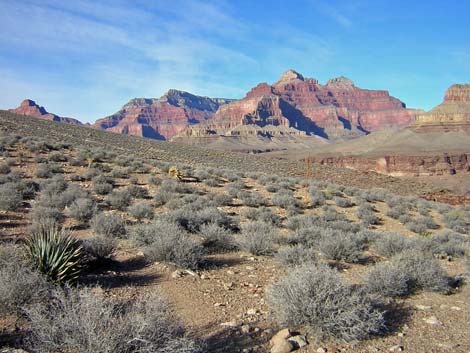
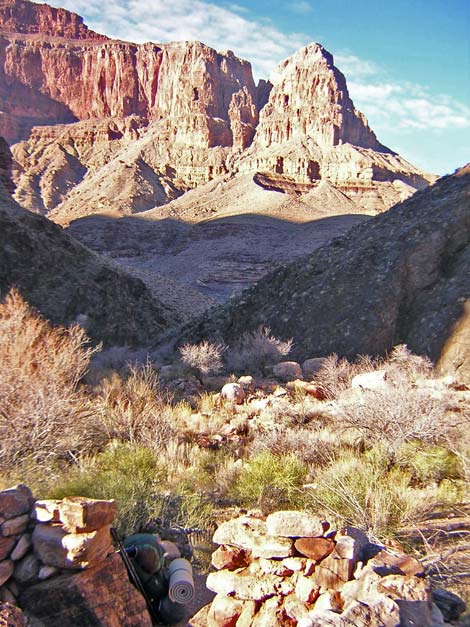 Remains of Boucher Cabin (view NW) |
Overview This description of the Tonto West Trail is divided into two parts: (1) an overview of the entire trail, trailheads, and other general information, and (2) individual canyon-to-canyon segments. From the camping area on Boucher Creek, it is about 5.2 miles and 2.75 hours to the wash in Slate Canyon. Water is available in Boucher Canyon and from a spring below the trail in Slate Canyon; seasonal water may be available at Slate Wash. This segment of the trail climbs steeply out of Boucher Canyon, runs down along the edge of the Inner Gorge beneath Marsh Butte (ridge below Dana Temple), and then runs back into Slate Canyon. The trail is always faint, and hikers should expect to spend some time off-route and looking for the trail. Boucher Creek is in Backcountry Use Zone BN9 (at-large camping), and after turning out of the Boucher drainage, the trail runs through Zone BO9 (at-large camping). Link to map of this segment. |
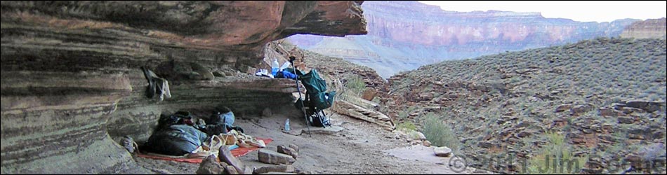
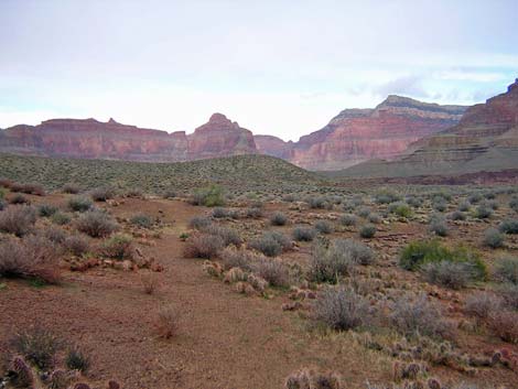
 Boucher Creek (view N) |
Watch Out Other than the standard warnings about hiking in the desert, ...be sure to read the Watch Out section on the Tonto West Overview page, which discusses things such as cell phones and signal mirrors. While hiking, please respect the land and the other people out there, and please try to Leave No Trace of your passage. Getting to the Trailhead Trailhead information is presented on the Tonto West Overview page. The Hike 10. Boucher Creek to Slate Canyon -- 5.2 miles and 2.75 hours From the camping area along Boucher Creek (Table 10, Waypoint 033), the trail runs down Boucher Creek to the confluence of Topaz Canyon (Wpt. 034). The trail mostly just runs down the streambed, but close to camp and near Topaz Canyon, you can avoid walking in the creekbed by staying along the north wall of the canyon. |
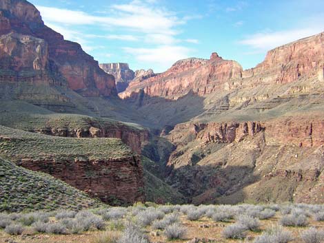
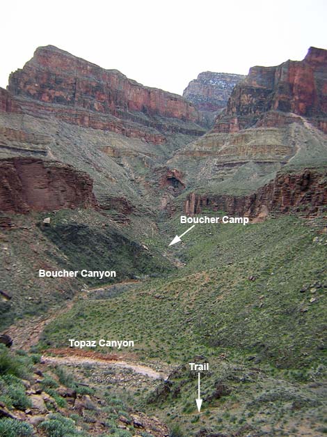 Confluence of Boucher and Topaz canyons (view SE) |
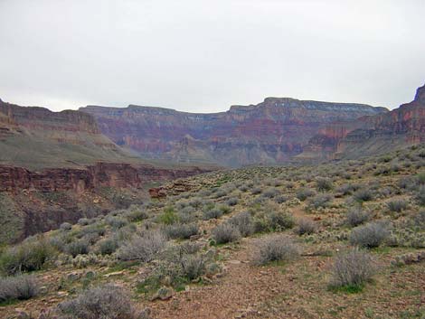
In this section, the trail runs in the Vishnu Schist, the ancient Precambrian rock that forms the Inner Gorge. These black rocks are contorted and contain many ribbons of white quartz (dikes), revealing a history of tectonic activity, metamorphism, and volcanic activity. This is the only place where the Tonto West Trail gets this far down into the Vishnu Schist. The cliffs above the Vishnu Schist are Tapeats Sandstone, and the Tonto Platform rests on the Tapeats, giving you an idea of how high up you need to climb to get out of Boucher Canyon. Before leaving Boucher Creek, consider hiking down to Boucher Rapids, the easiest side trip to the Colorado River along the Tonto West Trail. From the confluence of Boucher and Topaz canyons (Wpt. 034), the trail leaves the creekbed and climbs steep hillsides to the north to get back above the Tapeats Sandstone cliffs and onto the flats of the Tonto Platform. The start isn't obvious, so take a minute before leaving the creekbed to look for the trail on the hillside. After you get on the trail, it is fairly obvious and easy to follow. From the creekbed, it is a steep and rocky 0.4 miles to get above the cliffs, and another 0.3 miles to get onto the flats of the Tonto Platform. |
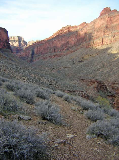
 Faint trail (view E) |
Leaving the creek bed (Wpt. 034), the trail climbs onto a bench on the north side of the wash, then runs northwest to climb steeply up the east side of a little rocky ridge to a saddle area on the ridge just below the Tapeats cliffs (Wpt. 035), which is a good place to stop and catch your breath. The trail continues steeply up the rocky hillside to the north, running through a broken section of the cliffs (left of the white boulders). The trail is steep, rocky, and loose, but above the cliffs, the grade eases as the trail runs east towards the river. A short bit of trail runs right along the edge of the Tapeats cliffs, providing great views into Boucher Canyon (Wpt 036), then the trail angles away from the edge and runs northeast up a gentle side canyon to get back onto the flats (Wpt. 037). Back on the flats, it is a brief walk (0.5 mi) to the end of the bluffs overlooking the river, a point with nice campsites and another grand view of the canyon (Wpt. 038). This is the point where the trail turns out of the Boucher Canyon drainage system. Up here, the trail is easy to follow and well-cairned where needed. |
 Faint trail (view N) |
The trail turns and runs north under the face of Marsh Butte for about 1.6 miles to the edge of Slate Canyon. This section of trail is fairly easy and well-marked. There are rocky gullies to cross, but the trail is good, the crossings are easy, and the views are grand. There are marginal campsites on the bluffs just before the turn into Slate Canyon (Wpt. 039). Turning into Slate Canyon (Wpt. 040), the trail crosses a broad saddle with some marginal campsites in a minefield of prickly-pear cactus. The trail over the saddle is faint, so watch carefully for signs of the trail and a few cairns. The dense minefield of low-growing, long needled, prickly pear cactus demands constant attention if you hike in running shoes. |
 Easy trail (view S) |
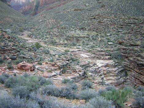
From the turn into Slate Canyon (Wpt. 040), the 2.4-mile (1.5 hour) hike into the back of Slate Canyon seems long and strenuous, but this might be because the trail is faint and requires constant attention. You will spend some time looking for the trail, but the trail is harder to follow when going west than going east. There is a trail the entire way, and the general strategy for following it is to stay low, closer to the edge of Slate Canyon than you might expect. My voice recording from the trail was: "Follow the cairns with the trail: if it doesn't look like a trail, you are off route." There are several off-route cairn trails on the hillside, but they all run too high on the hillside. From the turn into Slate Canyon (Wpt. 040), the trail curves to the southwest and gently starts into Slate Canyon. After about 15 minutes, the trail starts into the first of two major side canyons (Wpt. 041), both of which have two major gullies. In the back of the first gully in the first side canyon, the trail crosses a wash above a band of cliffs; there are overhangs below the cliffs that would be good campsites in the rain; but they get afternoon sun, so there would be no shade during the heat of the day. |
 Slate Canyon (view W) |
In the back of the main part of the side canyon, the trail crosses a rubble field. There is a good trail with cairns through the rubble field, but there are extra cairns off-route and uphill from the trail: follow the cairns with the trail. Starting into the gully, the trail passes under a catclaw acacia and drops into the bottom of the gully at the edge of the rubble field (Wpt. 042). The trail goes upstream for a few steps, then turns right and starts down and across the hillside until angling up and across the center of rubble field, heading for very large boulders upstream on the far side. On the far side of the first side canyon (Wpt. 043), the trail crosses the second major gully on an obscure trail with few cairns, then climbs steeply across a hillside and onto a saddle with green and purple dirt (Wpt. 044). This is the high point on the east side of Slate Canyon. |
 Trail into Slate Canyon (view W) |
From the high point, the trail runs downhill, quickly crossing a few more small, easy ravines until it runs over a low saddle a campsite on the point between the two major side canyons (Wpt 045). From this saddle, the trail runs oddly; it runs straight down a shallow ravine to the edge of the cliffs, and then turns west along the edge of the canyon. Remember, stay low, and stay on the trail. About 5 minutes beyond that saddle, the trail turns into the second major side canyon (Wpt 046). The trail runs around the hillside and into the back of the first major gully (Wpt. 047), which turns out to be a useful landmark. The trail crosses this gully on the long arc of a white sandstone pour-over. This pour-over is recognizable by two huge limestone boulders and a large acacia just above the pour-over, a chocolate-brown boulder on the edge of the pour-over, and four large chocolate-brown boulders in the gully just below the pour-over. A small, shallow gully lies about 150 yards west of this large gully. On the hillside just past the smaller gully (Wpt. 048), the faint trail forks, although it looks more like bushes in the trail rather than a fork. Your experience on the Tonto would tell you to take the upper fork and stay on the contour, but take the downhill fork. The lower fork runs easily around the hillside and into the second major gully in this side canyon. The trail enters this gully in a rubble field, but there is a trail and cairns to follow. Another string of cairns crosses the gully higher up; I've been there and done that; it is not a better way to go. Across the rubble field, but just before climbing the bank on the other side, the trail crosses a wash (Wpt. 049), passing between a pair of large sandstone boulders. The upstream boulder is red, and the downstream one is white (with a large acacia). |
 Slate Canyon (view E) |
At the edge of the wash, you will be facing west, towards the steep side of the gully and cairns. From the wash, the trail cuts downstream, and then angles up and right around the cliffs and up a hillside on an obscure trail. The goal is to scramble, as directly as possible, up the hillside and to the right (towards Slate Creek). After a moment or two, an obvious use-trail appears, which is followed up the hillside to the flats above. Atop the bluff (Wpt. 050), the use-trail joins the main trail, and there is a line of rocks across the main trail as if to say, "don't go this way," directing east-bound hikers down onto the use-trail. |
 Slate Canyon (view NW) |
From atop the bluff (Wpt. 050), a good trail runs north to the edge of the cliffs overlooking Slate Canyon gorge and a campsite (Wpt. 051). From there, an easy trail runs west towards the back of Slate Canyon, more or less staying on the contour. Just before getting to the next little side canyon, a large cairn (Wpt. 052) marks the start of the route down to the spring in the bottom of Slate Canyon (Wpt. 053). The route descends a steep, dirt hillside to the wash. I've not hiked down there, but from across the canyon, it looks like you should stay left below the Tapeats cliffs and circle around the toe of the ridge to the spring. The trail crosses another low saddle with a small campsite (Wpt. 054) before angling off the side of the cliff and dropping gently into Slate Creek. The trail runs into the wash on the contour and crosses the wash on the curve of a pour-over atop the Tapeats Sandstone (Wpt. 055). |
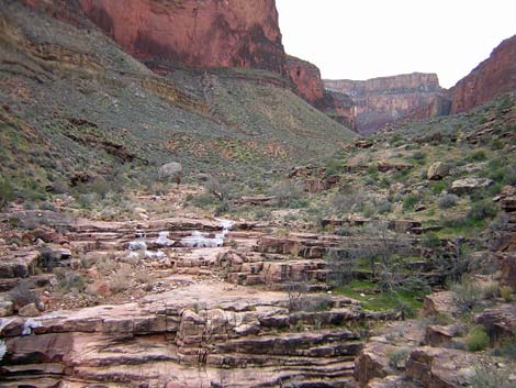 Ice on creek in Slate Canyon (view W) |
If you are hiking east from here, the trail follows the curve of the pour-over and cuts back out of Slate Canyon on the contour; follow the cairns. After about 30 seconds, the trail crosses the mouth of a side wash, and then cuts up the hillside to run above a little band of cliffs, still running along the side of Slate Canyon. There are several campsites at the wash crossing. There is a small campsite under the juniper on the east edge of the wash. On the west side of the wash, above the trail crossing, there is a very large pile of small rocks on the hillside that looks like a giant agave-roasting pit. There are campsites atop the rock pile and on rocky ledges just upstream from it. About 1 minute out the trail west of the wash, a ledge with an overhang makes a nice rainy-night campsite for one or two people. The next campsite to the west is about 30 minutes out the trail. There is a perennial spring about 0.5 miles down Slate Canyon from the crossing, and there may be seasonal water flowing in Slate Creek or in potholes below the trail crossing. I have read, but cannot verify, that you can get to the river by hiking down Slate Canyon. |
Table 10. Hiking Coordinates Based on GPS Data (NAD27; UTM Zone 12). Download Entire Route Waypoint (gpx) file.
| Wpt. | Location | Time | Easting | Northing | Elevation (ft) | Verified |
|---|---|---|---|---|---|---|
| 033 | Boucher camp (13) | 0800 | 388464 | 3996230 | 2,759 | GPS |
| 034 | Topaz Canyon (14) | 0828-0837 | 388372 | 3996715 | 2,647 | GPS |
| 035 | Flat area on ridge (14.5) | -- | 388194 | 3996838 | 2,820 | Map |
| 036 | Above the steep (15) | 0907 | 388357 | 3997056 | 3,108 | GPS |
| 037 | Tonto Platform (16) | 0918 | 388567 | 3997257 | 3,191 | GPS |
| 038 | Exit Boucher drainage (17) | 0925 | 388795 | 3997412 | 3,206 | GPS |
| 039 | Low ridge with campsite (18) | 1000 | 388520 | 3998753 | 3,309 | GPS |
| 040 | Turn into Slate drainage (19) | 1008-1230 | 388212 | 3998979 | 3,280 | GPS |
| 041 | Start into first side canyon (20) | 1021 | 387869 | 3998870 | 3,244 | GPS |
| 042 | Edge of a boulder field (21) | 1032 | 387758 | 3998435 | 3,248 | GPS |
| 043 | Hillside (22) | 1045 | 387643 | 3998347 | 3,231 | GPS |
| 044 | Green-and-purple saddle (23) | 1049 | 387566 | 3998437 | 3,290 | GPS |
| 045 | Saddle between side canyons (23.5) | -- | 387085 | 3998467 | 3,300 | Map |
| 046 | Starting into second major side canyon (24) | 1102 | 387010 | 3998399 | 3,222 | GPS |
| 047 | Pour-over with chocolate-brown boulders (25) | 1104 | 387025 | 3998324 | 3,223 | GPS |
| 048 | Trail forks (26) | 1110 | 386885 | 3998281 | 3,170 | GPS |
| 049 | Wash across rubble field (27) | 1116 | 386727 | 3998226 | 3,165 | GPS |
| 050 | Trail blocked by rocks (28) | 1120 | 386718 | 3998233 | 3,177 | GPS |
| 051 | Camp on bluffs (28.5) | -- | 386675 | 3998351 | 3,210 | Map |
| 052 | Cairn route down to Slate Spring (29) | 1126 | 386462 | 3998375 | 3,187 | GPS |
| XX4 | Slate Spring (XX4) | -- | 386550 | 3998520 | 2,720 | Map |
| 054 | Small camp on a saddle (30) | 1130 | 385960 | 3998327 | 3,161 | GPS |
| 055 | Slate Wash (31) | 1142 | 385765 | 3998279 | 3,120 | GPS |
Happy Hiking! All distances, elevations, and other facts are approximate.
![]() ; Last updated 240326
; Last updated 240326
| Hiking Around Grand Canyon | Hiking Around Las Vegas | Glossary | Copyright, Conditions, Disclaimer | Home |