Horn Creek to Salt Creek
Hiking Around Las Vegas, Grand Canyon National Park

Overview | Previous Segment | Next Segment
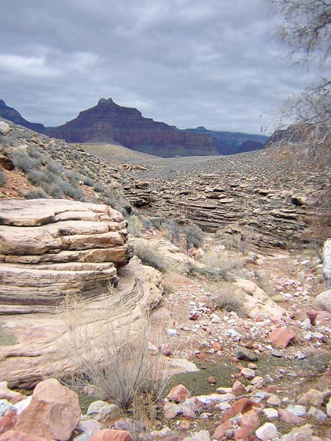 Tonto Trail at Horn Creek (view N) |
Overview This description of the Tonto West Trail is divided into two parts: (1) an overview of the entire trail, trailheads, and other general information, and (2) individual canyon-to-canyon segments. In addition, the Hermits Rest, Monument Creek, Havasupai Garden, Bright Angel Trailhead loop (west to east) is described separately because this is a popular loop, and it is easier to follow descriptions going forward than going backwards. From the east horn of Horn Creek, it is about 4.8 miles and 2.5 hours to Salt Creek, the first camping area to the west. There is no drinkable water along this segment. This segment of trail runs out the west side of Horn Creek, loops around Dana Butte (on the ridge below Hopi Point), and runs back into Salt Creek. The trail is fast, wide, easy, and provides many grand views above and below the trail. Horn Creek is in Backcountry Use Zone BL4 (camping only in designated campsites), and Salt Creek is in Zone BL5 (camping only in designated campsites). Link to map of this segment. Watch Out Other than the standard warnings about hiking in the desert, ...be sure to read the Watch Out section on the Tonto West Overview page, which discusses things such as cell phones and signal mirrors. While hiking, please respect the land and the other people out there, and please try to Leave No Trace of your passage. |
 East horn of Horn Creek (view S) |
Getting to the Trailhead Trailhead information is presented on the Tonto West Overview page. The Hike 2. Horn Creek to Salt Creek -- 4.8 miles and 2.5 hours From the wash crossing at the east horn of Horn Creek (Table 2, Waypoint 006) the trail runs on an easily contour around a ridge and into the west horn of Horn Creek (Wpt. 007). From the wash crossing on the west horn of Horn Creek (Wpt. 007), the trail runs north along the top of the Tapeats Sandstone. The trail is exceptionally pleasant, and only first few minutes are even rocky. The trail leaves the edge of the Tapeats (Wpt. 008) and turns slightly west on an unusually straight piece of trail (like nothing else on the entire trail). This section may have been an old fenceline or a road; it is too straight and long for a trail. The trail bends more to the west, runs up a rocky erosion gully, and climbs onto a low saddle to cross out of the Horn Creek drainage system. From the low saddle, you can look up Horn Canyon and see Hopi Point (above Dana Butte) and Maricopa Point on the rim to the east. Between the two, you can also see scaffolding from the old uranium mining operation. The mine is actually on the side of the cliffs about 1,000 feet below the rim. The water in Horn Creek is contaminated with uranium from the mine. You can also see Grandview Tower far to the east and the communications towers above the South Rim Village area. From the low saddle, the trail drops and runs west around a large side canyon. On the west side of the side canyon, the trail runs straight up the hillside in a rocky erosion gully to another saddle under the northeast toe of Dana Butte. This saddle, the high point on the trail between Horn and Salt creeks, provides spectacular views to the east. Before getting to this saddle, the trail passes a nice point with an illegal campsite. |
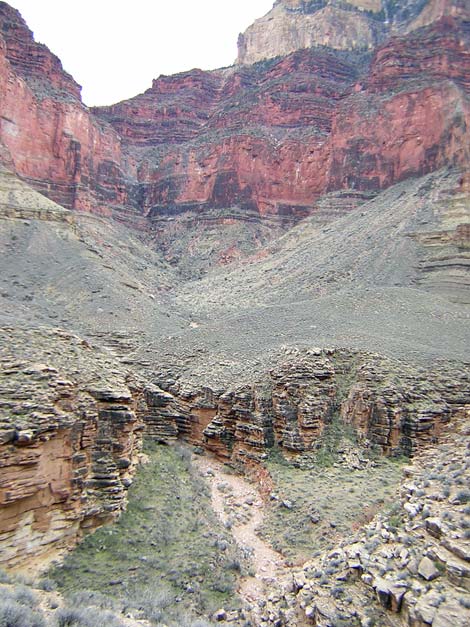
 Horn Canyon (view S) |
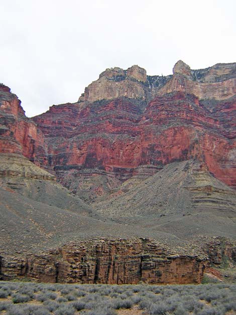
The trail drops across the hillside and crosses a saddle below the northwest toe of Dana Butte (Wpt. 009). There is another small illegal campsite with grand views down the river on the saddle. Just beyond the point, there are some awesome views down the river. From the point (Wpt. 009), the trail turns southwest into the Salt Creek drainage system. The trail winds around three side canyons on a good, but rocky trail that runs high across the slope. Going into the first side canyon, there are nice cliffy sections with great views into the canyon, but the river is not visible. After the last side canyon, the trail runs along the edge of the Salt Creek gorge atop the Tapeats Sandstone. Eventually, the trail drops off the Tonto Platform and runs down an easy ramp into the gorge and the Salt Creek wash crossings (Wpt. 010). From the wash, the trail switchbacks at a moderate grade up through the Tapeats Sandstone on the west side of the gorge to regain the Tonto Platform, where the trail to Salt Creek Campground forks off and runs south, farther back into the canyon. The campsites are a short distance up the canyon. There is a pit toilet, which is reported to be merely a seat with a grand view. The back of Salt Canyon is quite spectacular. The Redwall limestone cliffs above the trail are very red, close in, and wrap around to form a big cirque with Mohave Point on the west and Hopi Point on the east. This area, "The Inferno," is well named by the red walls, and I can imagine that during summer, the color only adds to the temperature. The white sandstone cliffs and the green ponderosa pine trees above the Redwall nicely accent the reds. |
 Colorado River (view NE from Tonto Trail) |
 Trail on rocky hillside (view NW) |
 Trail on rocky hillside east of Salt Creek (view NE) |
 More to come ... |
Table 2. Hiking Coordinates Based on GPS Data (NAD27; UTM Zone 12). Download Entire Route Waypoint (gpx) file.
| Wpt. | Location | Time | Easting | Northing | Elevation (ft) | Verified |
|---|---|---|---|---|---|---|
| 006 | East Horn of Horn Canyon (B10) | 1043 | 397077 | 3993717 | 3,520 | Map |
| 007 | West Horn of Horn Canyon (B09) | 1033 | 396745 | 3993897 | 3,500 | Map |
| 008 | Trail leaves edge of cliffs (B08) | 1015 | 397325 | 3994549 | 3,620 | Map |
| 009 | Northwest ridge of Dana Butte (B07) | 0927 | 396333 | 3995629 | 3,700 | Map |
| 010 | Salt Creek (B06) | 0832 | 395461 | 3993761 | 3,410 | Map |
Happy Hiking! All distances, elevations, and other facts are approximate.
![]() ; Last updated 240326
; Last updated 240326
| Hiking Around Grand Canyon | Hiking Around Las Vegas | Glossary | Copyright, Conditions, Disclaimer | Home |