Hiking Around Las Vegas, Desert National Wildlife Refuge
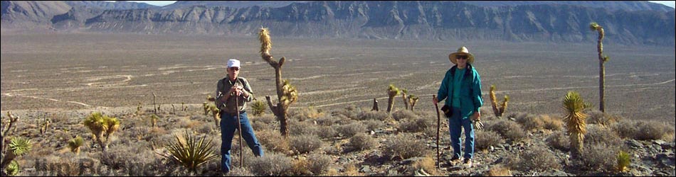
 View from the trailhead (view NW) |
Overview This is a moderately strenuous off-trail hike that runs up a wash, then up a hillside, and onto the top of a ridge with lots of Paleozoic fossils in the bedrock and in the surrounding rubble. The route is fairly short, only about 3/4 of a mile, so it makes for a nice desert hike during the short days of winter. Link to map. For general information on camping, hiking, regulations, other issues, and the natural history of the Wildlife Refuge, see the Desert National Wildlife Refuge -- Area Overview page. |
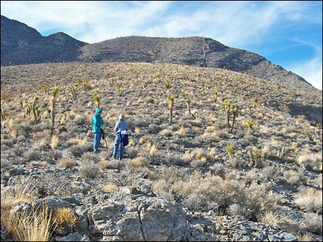
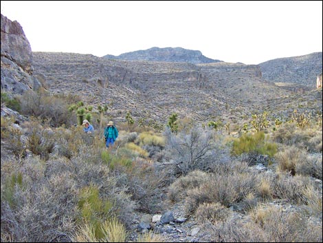 Hikers in the canyon, about ready to start up hillside (view W) |
Watch Out Other than the standard warnings about hiking in the desert, ...this route has some steep parts with loose scree and a few little limestone cliffs. The cliffs are fairly easy to scramble around, but watch your step. During warmer weather, watch for snakes in the wash and watch where you put your hands when climbing around the limestone cliffs. While hiking, please respect the land and the other people out there, and try to Leave No Trace of your passage. Also, even though this hike is short, it is pretty wild country, so be sure to bring the 10 Essentials. This is a wildlife refuge, so pay extra attention to respecting the land. Please, don't bother the bighorn sheep. They have a hard enough time making a living in these desert lands. |
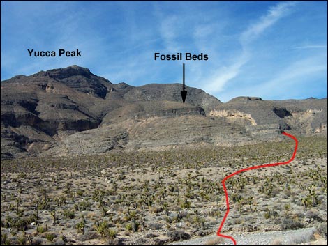
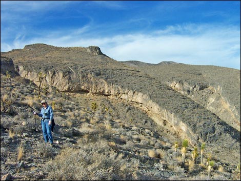
 Route from the wash to the fossil site (view S) |
Getting to the Trailhead This hike is located on the Desert National Wildlife Refuge, about 1-1/4 hours northwest of town. From town, drive out to Corn Creek Field Station and continue east 50 yards to a T-intersection. Turn right onto Mormon Well Road and drive south and east following the road for 9.0 miles as is bends around to the north and runs up along the east side of the Sheep Range. At a hard curve to the right, a sign announces Long Canyon. Turn left into the large, fenced parking area. Park here; this is the Long Canyon Trailhead. On the way out, at 1.0 miles past Gass Peak Road, stop for a few minutes can check out the snail fossil site. |
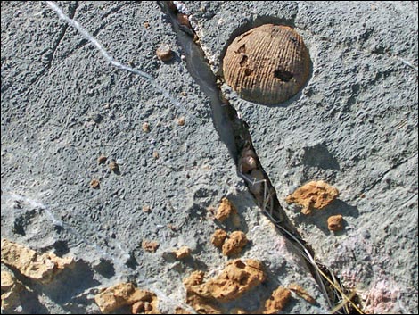
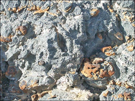
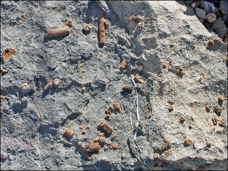
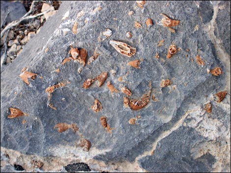
 Hiker at the fossil beds (view NW) |
The Hike The trailhead is on the top of a dirt cliff overlooking Long Canyon Wash. From the parking area (Table 1, Waypoint 01), the route runs north along the edge of the cliff for about 30 yards (to the 3rd or 4th Joshua tree on the left past the "No Vehicles" sign), and then drops into the wash on a lightly used use-trail. The route continues up and across the broad wash, heading a little bit north of northwest, aiming for the first big side canyon north of the parking area on the far side of the wash. The entrance to this canyon has limestone cliffs along the south (left) side. Dropping into the wash, the route passes a big log carried down from Long Canyon by flash floods (think about that for a moment when you get there). By the log, check the larger rocks for fossils. |
 Hikers at the fossil beds (view W) |
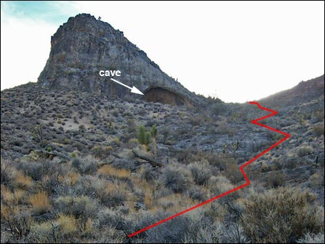
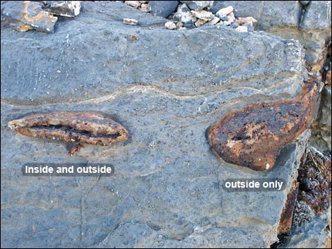
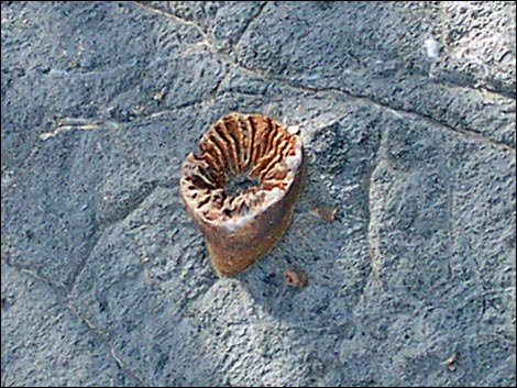
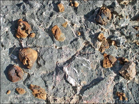
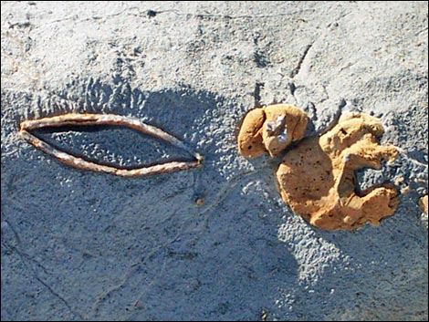
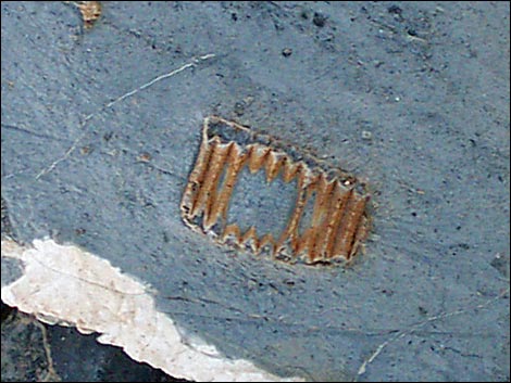
From the log, continue north-northwest and cross over a little ridge between the wash coming down from Long Canyon and the wash coming down from the canyon the route follows. Hiking across the wash, watch the rocks under your feet for fossils. We found some nice fossil crinoids, "worm trails," snails, brachiopods, and bryozoans in the wash. Entering the side canyon (Wpt. 02), the route passes a band of short cliffs on the south (left) side of the wash. There are some interesting little caves in the cliffs, and some have large packrat (Desert Woodrat) nests in them, but we found no fossils in this area. The route stays in the wash to a point past the little cliffs where a gully comes down the steep hillside (Wpt. 03). Looking up the gully, a limestone buttress with a large cave can be seen. |
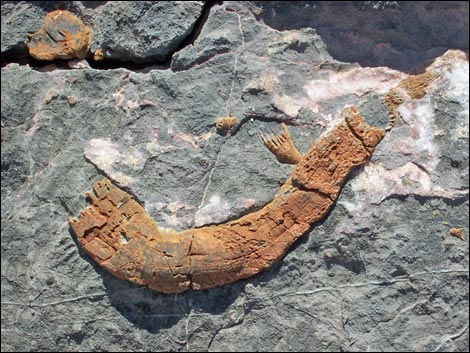 |
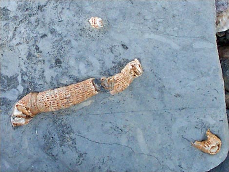
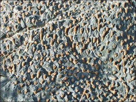
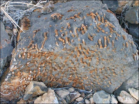
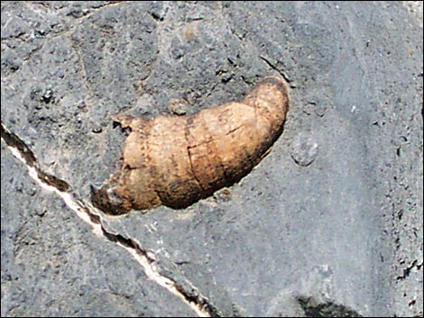
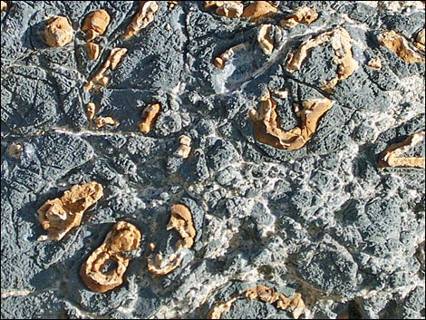
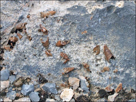
A gully runs up the hillside to the cave. The route runs up the gully. At the first place where limestone bedrock is exposed, stop to see some nice horn corals. The route continues up the gully, moving to the west (right) through a series of ledges and cliffs (Wpt. 04) that are at about the same elevation as the cave. The route passes to the west of the buttress on a fairly steep hillside, then climbs to the top of the ridge. There are many interesting fossils in the cliffs and in the rubble on the hillside. We found fossil corals, sponges, horn corals, and crinoids here. The route continues to the top of the ridge (Wpt. 05). We found many fossils on the top of the ridge in this area. We also found many fossils to the east and south of where we crested out (this is the top of the big limestone cliffs that you can see while hiking out across the washes), but relatively few fossils higher up the ridge. |
 |
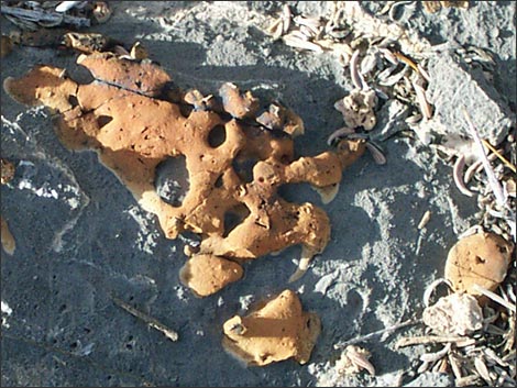
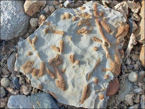
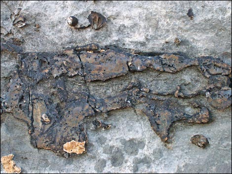
To get back to the trailhead, retrace your steps (the easy way) or you can head southeast down the ridge for about 0.11 miles to the end of the ridge where hikers can circle around under the big limestone cliffs before dropping down a hillside and gully into the main washes at the bottom of the mountain. There are some nice fossils (but nothing new) in the outcrops along the south end of the big cliffs, but it is much easier to follow your footprints back down. Remember that this is a wildlife refuge and that everything is protected, so enjoy the fossils you find, but leave them in place for the next person to find too. On the way back down the Mormon Well Road, stop and see the fossil snail shells along the base of Fossil Ridge. As the road runs through Yucca Gap, there is a place where the road runs right along the base of Fossil Ridge (i.e., no bushes between the road and the cliffs). Immediately before (east of) this point, stop in the pullout on the south side of the road and look at the rocks behind the parking area. Amazing. |
 |
 |
 |
 |
 |
 |
 |
 |
 |
 |
 |
 |
 |
 |
 |
 |
 |
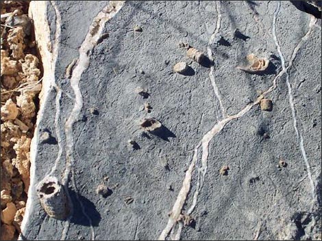 |
Table 1. Hiking Coordinates Based on GPS Data (NAD27, UTM Zone 11S). Download Hiking GPS Waypoints (*.gpx) file.
| Wpt. | Location | Easting | Northing | Elevation (ft) | Point-to-Point Distance (mi)* | Cumulative Distance (mi) | Verified |
|---|---|---|---|---|---|---|---|
| 01 | Trailhead | 658347 | 4038084 | 4,988 | 0.00 | 0.00 | Yes |
| 02 | Mouth of the canyon | 657930 | 4038655 | 5,150 | 0.48 | 0.48 | map |
| 03 | Base of the gully | 657790 | 4038751 | 5,200 | 0.11 | 0.59 | map |
| 04 | Hillside opposite cave | 657610 | 4038651 | 5,400 | 0.11 | 0.70 | map |
| 05 | Fossil beds | 657471 | 4038666 | 5,517 | 0.12 | 0.82 | GPS |
| 01 | Trailhead | 658347 | 4038084 | 4,988 | 0.82 | 1.64 | Yes |
Happy Hiking! All distances, elevations, and other facts are approximate.
![]() ; Last updated 240324
; Last updated 240324
| Hiking Around DNWR | Hiking Around Las Vegas | Glossary | Copyright, Conditions, Disclaimer | Home |