Hiking Around Las Vegas, Zion National Park
 Angel's Landing (view N from near trailhead) |
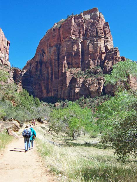
Overview This strenuous route runs up a steep paved trail for 2 miles to Scout Overlook, an overlook on the edge of the ridge that connects Angel's Landing to the rim of Zion Canyon. The route then runs another 0.5 miles up steep, exposed ledges along the narrow ridge to the summit. Chains along the exposed portions of the route provide handholds that give an illusion of safety, but this trail is not for those with a fear of heights. The views from the summit are spectacular, and this is a great hike. Link to map. Watch Out Other than the standard warnings about hiking in the desert, ...a slip from many places along the trail would result in serious injury, so be careful and watch your kids (other people's kids too). The 4th-class sections on the summit ridge take some care, as a fall from there would result in certain death, but they are not difficult, and there are chains for handholds along the more-exposed sections. While hiking, please respect the land and the other people out there, and try to Leave No Trace of your passage. Also, even though this is a short hike, be sure to bring what you need of the 10 Essentials. |
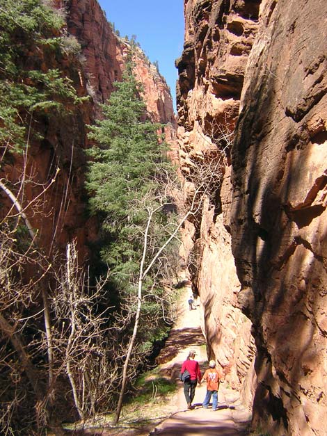
 Cliffs and Refrigerator Canyon (view N from trail) |
Getting to the Trailhead This hike is located in Zion National Park, about 3 hours northwest of Las Vegas. From town, drive out to Zion National Park. From the Visitor Center (Table 1, Site 863), drive or ride the shuttle bus north on Highway 9 for about 1.3 miles to Zion Canyon Road (Site 864). Turn left onto Zion Canyon Road and drive north for about 3.3 miles to the Grotto Picnic Area (Site 865). Park here; this is the trailhead. |
 Switchbacks through the vertical cliffs (view S) |
The Hike From the shuttle bus stop at the Grotto Picnic Area trailhead (Table 2, Waypoint 1), the trail starts across the highway to the west. The trail runs west for about 0.10 miles and crosses a footbridge over the Virgin River (Wpt. 2), then turns north and follows the river upstream. The trail runs north for about 0.37 miles on a bench between the rocky hillside and the floodplain, then turns uphill (Wpt. 3) and begins switchbacking steeply up the side of canyon towards the base of the cliffs that tower above the trail. This part of the trail is fairly steep, but it is paved and easy to walk on, and there are places to stop and rest in the shade of Two-needle Pinyon and Utah Juniper trees. |
 Refrigerator Canyon (view N) |
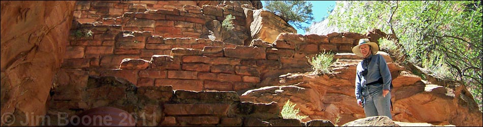
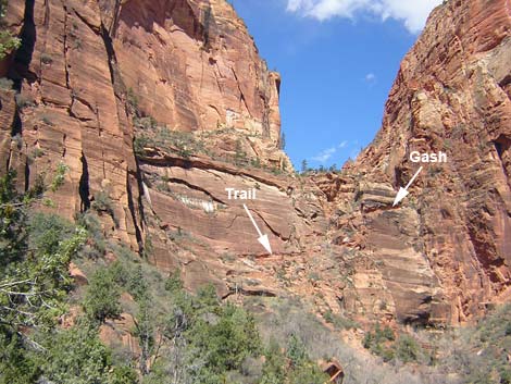
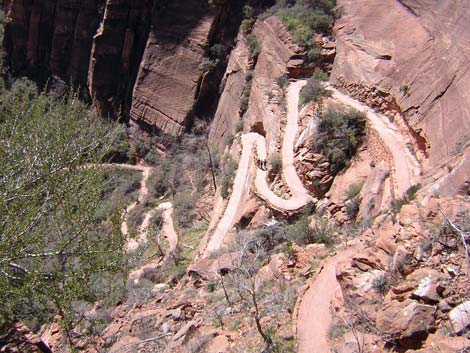
After climbing a couple of switchbacks, the trail runs north along the base of the cliffs until the flat space for a trail runs out. The trail then begins working up the cliffside on built-up ledges and blasted-out sections of rock through the cliffs, all of which is paved. When the ledges finally give out, the trail runs steeply up and across the face of the cliff and around a corner through a gash in the cliff that was blasted out of solid rock (Wpt. 4). This section of trail is pretty exposed, especially at the corner. If the exposure gives you trouble here, don't hike past Scout Overlook. The trail through the blasted-out section of cliff leads to the mouth of Refrigerator Canyon, where the nature of the hike changes abruptly. Up to this point, the trail has been steep, highly exposed, and hot, but now the trail runs in the bottom of a cool, deep, narrow canyon with White Firs, Velvet Ash, and Ponderosa Pine. The paved trail runs northwest along the bottom of Refrigerator Canyon for a few-hundred yards, then starts switch-backing up the eastern wall of the canyon towards the crest of the Angel's Landing ridge. At the top of this section of trail, a series of 21, short, steep switchbacks, called Walter's Wiggles (Wpt. 5), leads to the top of the ridge. The CCC did some nice stonework along here. At the top of Walter's Wiggles, the pavement ends, and a few yards of sandy trail leads to the trail junction with the West Rim Trail (Wpt. 6). A few feet up that trail, two outhouses are tucked under the trees. |
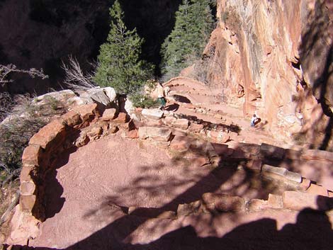 Walter's Wiggles (view N, from above) |
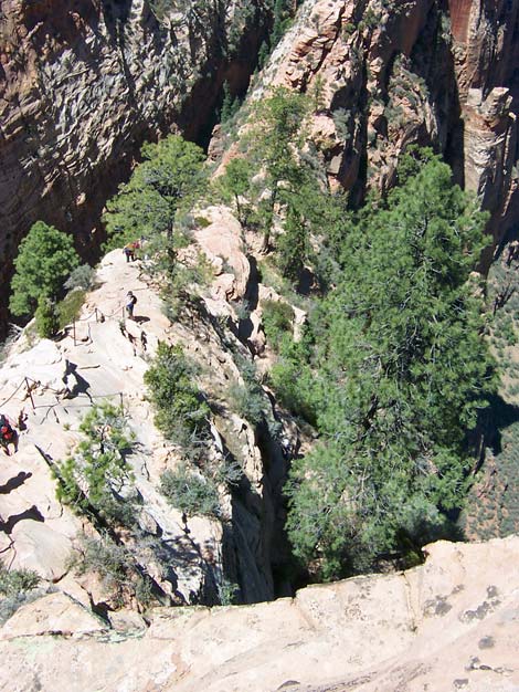
Just past the trail junction, the trail runs onto sandstone slickrock at Scout Overlook (Wpt. 7), a place with a spectacular view down the east side of Angel's Landing to the Virgin River, some 1,200 feet below. A guard rail permits safely walking out to the edge of the cliff. For many people, this is a good place to stop and enjoy the view, fight with the chipmunks for your lunch, and relax before heading back down. From Scout Overlook, a route runs south and over a knob on the ridge where the trail crosses some steep, exposed slickrock. There is a big chain to hold onto, and the trail crew chipped steps into the rock, so it is exposed but not physically or technically difficult. Nonetheless, this is steep and exposed, so watch the children carefully. |
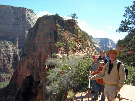 Scout Overlook (view N to Angels Landing summit) |
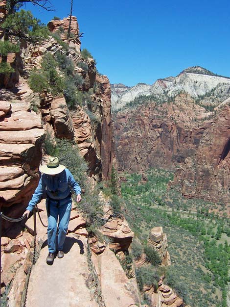
Past the knob, the trail runs over a saddle (Wpt. 8) on the ridge where the trail is only about 2 feet wide, 1,200 feet down to the Virgin River on one side, and 800 feet down to the bottom of the canyon on the other side. There is a chain, but it is pretty airy. If there are rock climbers on the upper portion of the Angel's Landing route, this is a good place to watch them. After the narrow saddle, the steep part starts. The route is narrow and extremely exposed, but the views are spectacular in all directions, especially back down at the trail ("Wow, I came up that!?!"). The route is amazingly steep and exposed as it winds up one side and then the other side of the ridge. There are chains at all of the really exposed sections, but there are many places where you could fall to your death. |
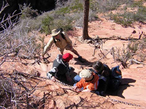 Working along the chains just past Scout Lookout (view W) |
Eventually, the trail climbs one last steep section and arrives at the summit (Wpt. 9), which is a long flat ridgetop. The views from the tip of the ridge, which is slightly past the highest point, are spectacular. The tip juts out into Zion Canyon, so you get great view up and down the canyon, as well as off to the east across the canyon. To get back to the trailhead, retrace your footprints (such as they are on the slickrock and paved trail). |
 1,200 feet down the right; and 800 feet down the left (view N) |
 Narrow ridge between Scout Lookout and the summit (view N) |
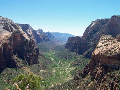 Zion Canyon (view S from Angel's Landing summit) |
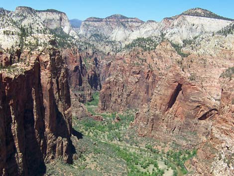 Zion Canyon (view N from Angel's Landing summit) |
Table 1. Highway Coordinates Based on GPS Data (NAD27; UTM Zone 12S). Note: These are UTM-Zone-12 coordinates.
Download Highway GPS Waypoints (*.gpx) file.
| Site # | Location | Latitude (°N) | Longitude (°W) | UTM Easting | UTM Northing | Elevation (feet) | Verified |
|---|---|---|---|---|---|---|---|
| 0863 | Zion Visitor Center | 37.2002 | 112.9862 | 323726 | 4118724 | 3,896 | Yes |
| 0864 | Highway 9 at Zion Canyon Road | 37.2176 | 112.9736 | 324881 | 4120630 | 4,048 | Yes |
| 0865 | Grotto Picnic Area, shuttle bus stop | 37.2592 | 112.9502 | 327055 | 4125200 | 4,281 | Yes |
Table 2. Hiking Coordinates based on GPS data (NAD27; UTM Zone 12S). Note: These are UTM-Zone-12 coordinates.
Download GPS Waypoints (*.gpx) file.
| Wpt. | Location | Easting | Northing | Elevation (ft) | Verified |
|---|---|---|---|---|---|
| 01 | Grotto Picnic Area trailhead (bus stop) | 327055 | 4125200 | 4,281 | Yes |
| 02 | Bridge over Virgin River | 327018 | 4125285 | 4,276 | GPS |
| 03 | Trail turns uphill | 327117 | 4125829 | 4,353 | GPS |
| 04 | Gash in the cliff | 327108 | 4126352 | 4,640 | GPS |
| 05 | Walter's Wiggles | 327052 | 4127032 | 5,000 | GPS |
| 06 | West Rim Trail junction | 327111 | 4126950 | 5,291 | GPS |
| 07 | Scout Overlook | 327127 | 4126930 | 5,332 | GPS |
| 08 | Narrow neck | 327162 | 4126718 | 5,444 | GPS |
| 09 | Summit | 327352 | 4126321 | 5,790 | GPS |
Happy Hiking! All distances, elevations, and other facts are approximate.
![]() ; Last updated 240330
; Last updated 240330
| Hiking Around Zion National Park | Hiking Around Las Vegas | Glossary | Copyright, Conditions, Disclaimer | Home |