Cedar Spring to Monument Creek
Hiking Around Las Vegas, Grand Canyon National Park

Overview | Previous Segment | Next Segment
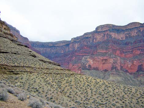
 Cedar Spring (view NW) |
Overview This description of the Tonto West Trail is divided into two parts: (1) an overview of the entire trail, trailheads, and other general information, and (2) individual canyon-to-canyon segments. In addition, the Hermits Rest, Monument Creek, Havasupai Garden, Bright Angel Trailhead loop (west to east) is described separately because this is a popular loop, and it is easier to follow descriptions going forward than going backwards. From Cedar Spring, it is about 1.3 miles and 45 minutes to Monument Creek, the next water source and camping area to the west. This segment of the trail runs around the west arm of the Alligator, one of the ridges below Mohave Point, and back into Monument Canyon. Except for getting down the Tapeats cliffs to Monument Creek, this segment of the trail is easy, fast, and wide, but with a few rocky spots. The trail down into Monument gorge is steep and rocky, but it is a fine trail. There are many grand views. Water is available at Cedar Spring and Monument Creek. Cedar Spring is in Backcountry Use Zone BL6 (camping only in designated campsites), and Monument Creek is in Zone BL7 (camping only in the campground). Link to map of this segment. |
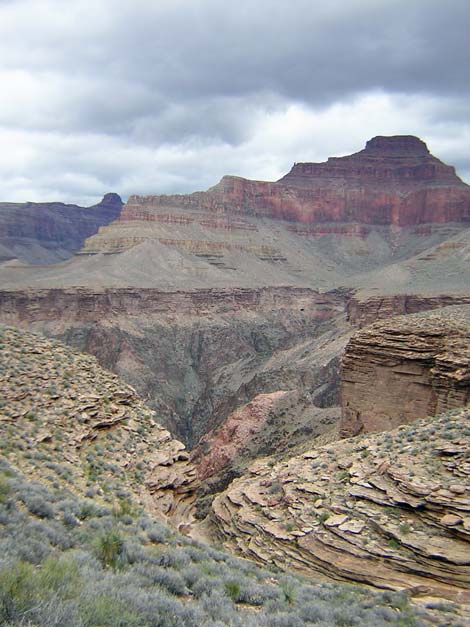 Side canyon and Inner Gorge (view N) |
Watch Out Other than the standard warnings about hiking in the desert, ...be sure to read the Watch Out section on the Tonto West Overview page, which discusses things such as cell phones and signal mirrors. While hiking, please respect the land and the other people out there, and please try to Leave No Trace of your passage. Getting to the Trailhead Trailhead information is presented on the Tonto West Overview page. The Hike 4. Cedar Spring to Monument Creek -- 1.3 miles and 45 minutes From Cedar Spring (Table 4, Waypoint 012), the trail runs west across the hillside to a low saddle. The trail then drops a bit steeply before crossing another saddle at the northwest arm of the Alligator (Wpt. 013), where the trail turns into the Monument Canyon drainage system. |
 Hillside and the cliffs of Monument Canyon (view SW) |
From the saddle, the trail drops down a side canyon to the lip of the Tapeats cliffs on the edge of Monument Canyon. From there, a good trail runs south along the contour towards the back of Monument Canyon, providing great views down into Monument gorge, including good views of the Monument and the campground that are located in the narrow gorge cut through the Tapeats Sandstone. On the cliffs above the campground, the trail starts to drop gently into the Tapeats layer, then abruptly turns over the edge and descends a series of short, steep, rocky switchbacks. The switchbacks drop through a short side canyon, ending at the edge of Monument Wash (Wpt. 014). |
 The Monument and trail across canyon (view W) |
The rocky, but well-defined trail ends in the side canyon about 20 feet before the edge of Monument Wash, a fact that obscures the trail for hikers going east. Note that the short side canyon is almost exactly even with the south end of the campground. Hiking from west to east, the trail starts at the south end of the campground, crosses the wash, and starts into the shallow side canyon with steep walls. About 20 feet beyond the edge of the wash, a good trail turns right and starts up the south side of the side canyon. The trail runs up a number of short, steep, rocky switchbacks through the Tapeats Sandstone cliffs and quickly gets back onto the Tonto Platform. |
 Monument Campground (view NW from trail atop Tapeats cliffs) |
Heading from east to west, the trail enters the campground near the south end of the campground and exits the north end by a 2-seat outhouse. The campground extends along the canyon for a few-minutes walk. The camp area is in a mesquite thicket, but the north end burned, so sites there are in full sun while others are sheltered under the trees. The southern-most campsite is located under a large rock overhang that serves as a passable rain shelter. Water is available from springs in the creek bed just downstream from the campground. The trail to the group campsite starts a short way out the trail north of the outhouse. Because the campground is located in a narrow gorge below the Tonto Platform, the views down the canyon are limited. However, there are nice views of the Redwall Limestone cliffs and Mohave Point, and the sculpted Tapeats Sandstone is quite interesting. Also, just below the springs, the creek flows out of the Tapeats Sandstone and into a narrow, water-polished gorge in the Vishnu Schist, which is quite pretty. The polished rocks are not slippery, and scrambling a short way down the canyon is easy. |
Table 4. Hiking Coordinates Based on GPS Data (NAD27; UTM Zone 12). Download Entire Route Waypoint (gpx) file.
| Wpt. | Location | Time | UTM Easting | UTM Northing | Elevation (ft) | Verified |
|---|---|---|---|---|---|---|
| 012 | Cedar Spring (B04) | 0734 | 394001 | 3994233 | 3,360 | Map |
| 013 | West Arm of the Alligator (B03) | 0720 | 393441 | 3994173 | 3,420 | Map |
| 014 | Monument Creek (B02) | 0649 | 393269 | 3993521 | 2,995 | Map |
Happy Hiking! All distances, elevations, and other facts are approximate.
![]() ; Last updated 240326
; Last updated 240326
| Hiking Around Grand Canyon | Hiking Around Las Vegas | Glossary | Copyright, Conditions, Disclaimer | Home |