Hiking Around Las Vegas, Hiking Around Death Valley National Park
 Telescope Peak Trailhead |
The Telescope Peak Area Trailheads are located along Charcoal Kiln Road (also called Mahogany Flat Road) in Death Valley National Park, about 4 hours northwest of Las Vegas. From town, drive out to Death Valley. From the Furnace Creek Visitor Center (Table 1, Site 0712), drive north on Highway 190 for 24 miles to Stovepipe Wells (Site 0751). Continue west on Highway 190 for another 9 miles to Wildrose Road (Site 0980). Turn left onto Wildrose Road and drive south and east, winding up into the mountains, for 21.4 miles to Wood Canyon Road (Site 1057). When Wildrose Road curves hard to the right to descend towards Trona, continue straight onto Wood Canyon Road, which becomes Charcoal Kiln Road. Link to Trailhead Map. |
 Rodgers Road Trailhead |
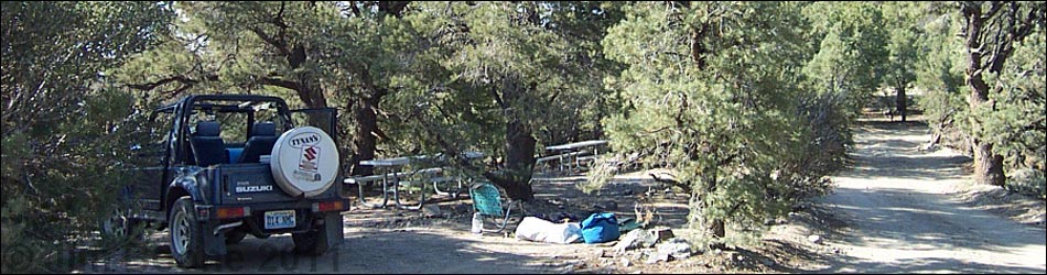
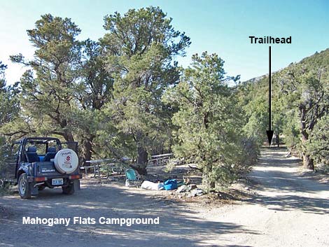
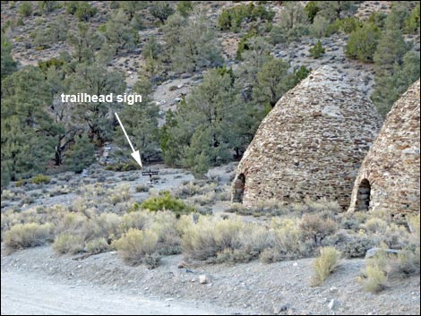
Continuing straight (left) onto Charcoal Kiln Road, the road shortly passes the entrance to Wildrose Campground (Site 1438) and then the Wildrose Ranger Station. Continuing east on the sometimes narrow, winding, and rough Charcoal Kiln Road, the pavement ends about 5.0 miles out. The sometimes-graded dirt road for runs east for another 2.1 miles to the Wildrose Charcoal Kilns day-use parking (Site 0765). For the Wildrose Peak Trail, day-use parking is on the right (southwest) side of the road across from the kilns (Site 0765). Park here; this is the Wildrose Trailhead. For the Telescope Peak Trail, continue up the rough road for 1.0 miles to Thorndike Campground (Site 1059) and another 0.7 miles to Mahogany Flat Campground (Site 0611). Hiker parking is located just before the campground (Site 0778) on the crest of the ridge. Park here; this is the trailhead. |
 Wildrose Peak Trailhead |
The last 2 miles of road, and especially the road above Thorndike, are rough and run straight up the bottom of a drainage. This steep, rough, and narrow gravel road is okay for 2WD-HC vehicles, and someone drove it in an old Honda Civic hatchback the weekend I first climbed the peaks, but the road may require 4WD if it is wet or washed out. The road is closed during winter. If visitors call the park to ask about road conditions, the rangers will only tell you that the road requires a 4WD vehicle. Hike from Thorndike if necessary, as this adds relatively little to the total hiking distance. The Telescope Peak Area Trailheads provide access to hikes in the high peaks region of the Panamint Mountain Range. Trails: Telescope Peak, Rodgers Peak (via trail), Rodgers Peak (via service road), Bennett Peak, and Wildrose Peak. |
Table 1. Highway Coordinates Based on GPS Data (NAD27; UTM Zone 11S). Download Highway GPS Waypoints (*.gpx) file.
| Site # | Location | Latitude (N) | Longitude (W) | Easting | Northing | Elevation (ft) | Verified |
|---|---|---|---|---|---|---|---|
| 0611 | Mahogany Flats Camp | 36.23049 | 117.06715 | 493965 | 4009315 | 8,133 | Yes |
| 0712 | Furnace Creek Visitor Center | 36.46159 | 116.86574 | 512030 | 4034954 | -186 | Yes |
| 0751 | Hwy 190 at Stovepipe Wells | 36.60654 | 117.14594 | 486948 | 4051034 | 0 | Yes |
| 0765 | Charcoal Kilns parking | 36.24673 | 117.07551 | 493216 | 4011116 | 6,885 | Yes |
| 0778 | Mahogany Flat Parking | 36.22995 | 117.06740 | 493943 | 4009255 | 8,135 | Yes |
| 0980 | Hwy 190 at Emigrant Canyon Rd | 36.49506 | 117.22613 | 479747 | 4038682 | 2,196 | Yes |
| 1057 | Emigrant Canyon Rd at Charcoal Kiln Rd | 36.26542 | 117.19109 | 482835 | 4013204 | 4,025 | Yes |
| 1059 | Thorndike Camp | 36.23712 | 117.07111 | 493610 | 4010051 | 7,546 | Yes |
| 1438 | Wildrose Camp Entrance | 36.26571 | 117.18964 | 482965 | 4013235 | 4170 | Yes |
Happy Hiking! All distances, elevations, and other facts are approximate.
![]() ; Last updated 240324
; Last updated 240324
| Hiking Around Death Valley | Hiking Around Las Vegas | Glossary | Copyright, Conditions, Disclaimer | Home |