Hiking Around Las Vegas, Death Valley National Park
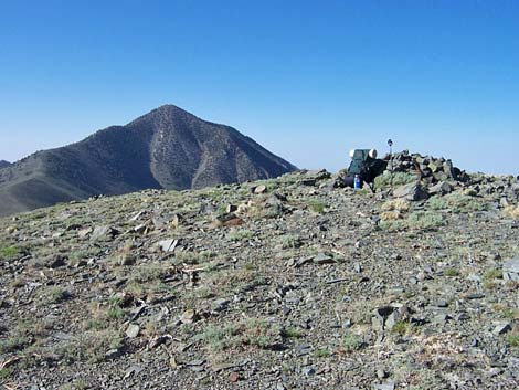
 Bennett Peak (view SW from the Telescope Peak trail) |
Overview This fairly strenuous, 2.5-mile hike follows the Telescope Peak Trail into the Death Valley Wilderness Area and up to Arcane Meadows, then runs cross-country up the north ridge of Bennett Peak. This hike is too long for just this one peak, so climbing it in conjunction with an ascent of Telescope Peak makes more sense. On the way down from Telescope, climb the south ridge to the summit of Bennett Peak, then descend the north ridge back to the trail. The views from the summit and many points along the route are spectacular. |
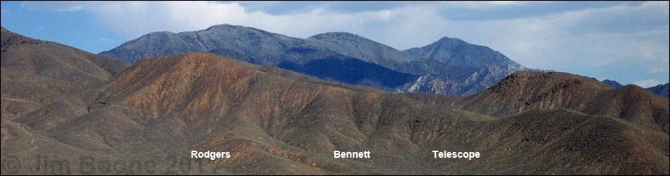
 Bennett Peak (view S from Rogers Peak) |
Watch Out Other than the standard warnings about hiking in the desert, ...this is a steep and narrow, but pretty safe trail when it is clear of snow. Stay off the ridges and the summit if lightning threatens. Snow accumulates on the ridges, and winter ascents might require ice axes, crampons, and mountaineering experience. Beware of altitude sickness, as the peak is some 10,000 feet higher than the surrounding desert valleys. There is no water at the campground, trailhead, or on the trail. Get water at Wildrose Campground. While hiking, please respect the land and the other people out there, and try to Leave No Trace of your passage. Also, this is a fairly long hike, so be sure to bring the 10 Essentials. This hike runs up into the Death Valley Wilderness Area, so pay particular attention to respecting the land. |
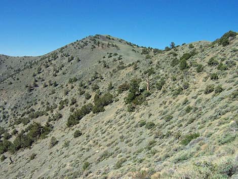
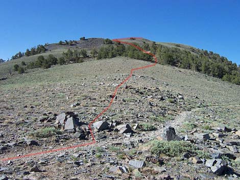
 Route up the south side of Bennett Peak (view N from the Telescope Peak Trail near the saddle between Bennett and Telescope peaks) |
Getting to the Trailhead This hike is located in Death Valley National Park, about 4 hours northwest of Las Vegas. From town, drive out to Death Valley, then continue on westbound Highway 190, past Stovepipe Wells to Emigrant Canyon Road. Turn left onto Emigrant Canyon Road and drive up into the mountains, eventually arriving at the Telescope Peak Trailhead. Park here; this is the trailhead. The last 0.7 miles to Mahogany Flat Campground might require a 4WD vehicle or a hike. |
 Summit of Bennett Peak (view S towards Telescope Peak) |
The Hike From the trailhead parking area (Table 2, Waypoint 1), hike up the Telescope Peak trail to the crest of the ridge (Wpt. 2) at Arcane Meadows (2.0 miles out). For details of this segment of the trail, see the description of the Telescope Peak route. From the high point at Arcane Meadows where the trail first hits the crest of the ridge, continue south on the Telescope Peak trail to the northwest side of Bennett Peak (0.17 miles beyond the crest). As the trail starts over a rocky little ridge and onto the west side of Bennett Peak (Wpt. 10), leave the trail and hike up the ridge, aiming for a knob of white rock about 0.18 miles out and half-way up the ridge. There are shade trees and a nice campsite by the white knob (Wpt. 8). From the knob, it is about 0.31 miles to the summit. Climb steeply to the top of the ridge, passing just west (right) of a boulder field. From the top of the ridge, it is a short and gentle walk to the summit (Wpt. 11), which is a total of about 0.49 miles from the Telescope Peak trail. |
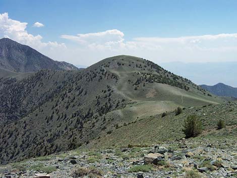
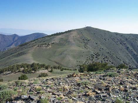 Bennett Peak vista (view N to Arcane Meadows, Rogers Peak, and Wildrose Peak) |
To climb Bennett on the way down from Telescope Peak, stay on the trail past the saddle between Bennett and Telescope peaks for about 0.2 miles. From the trail (Wpt. 13) below the first knob on the south ridge of Bennett Peak, leave the trail and angle up and northward across the sagebrush-covered slope towards a low saddle, which is about 0.15 miles from the trail. A small boulder field near the ridgeline makes for a good target. There are some use-trails in the sagebrush, so use them when you find them. After gaining the ridge (Wpt. 12), follow it up and north for another 0.3 miles to the summit (Wpt. 11). It is 0.45 miles from the trail to the summit. The vegetation on the ridge is sparse and low-growing, so after making it through the knee-high sage on the side of the ridge, the walking is easier. |
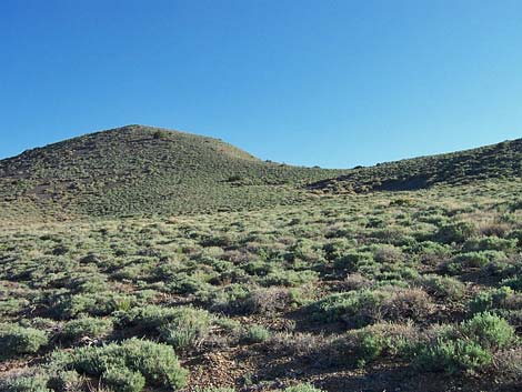
 Bennett Peak (view S from Telescope Peak trail in Arcane Meadows) |
The views from the summit are every bit as good as those from the top of Telescope Peak. You can see off to the west to the Mt. Whitney region in the Sierra Nevada mountains; north to Rogers and Wildrose peaks and Death Valley, east to Badwater, Dante's View, and peaks in Nevada, and south to Telescope Peak and other mountain ranges beyond. Vegetation on the summit is similar to the rest of the route (a few low-growing sagebrush, lupine, a few other shrubs, and wildflowers), but mostly it is bare rock. Along the route, watch for Panamint Chipmunks, Sagebrush Lizards, Rock Wrens, Clark's Nutcrackers, and Red Crossbills. Return to the trailhead by returning to Telescope Peak trail and following it back down, or consider climbing over Rogers Peak and follow the radio-tower road back to the campground. |
Table 2. Hiking Coordinates Based on GPS Data (NAD27, UTM Zone 11S). Download Hiking GPS Waypoints (*.gpx) file.
| Wpt. | Location | Easting | Northing | Elevation (ft) | Point-to-Point Distance | Cumulative Distance | Verified |
|---|---|---|---|---|---|---|---|
| 1 | Mahogany Flat Trailhead | 493943 | 4009255 | 8,133 | 0.00 | 0.00 | GPS |
| 2 | Arcane Meadows, crest of the ridge | 492077 | 4007487 | 9,571 | 2.00 | 2.00 | GPS |
| 10 | North Ridge of Bennett Peak | 491877 | 4007297 | 9,636 | 0.17 | 2.17 | GPS |
| 08 | White Knob | 491850 | 4007050 | 9,792 | 0.18 | 2.35 | GPS |
| 11 | Summit | 491741 | 4006658 | 9,956 | 0.31 | 2.66 | GPS |
| . | . | . | . | . | . | . | . |
| 13 | Leave Regular Trail | 491818 | 4006061 | 9,551 | 0.00 | 0.00 | GPS |
| 12 | Ridgeline | 491853 | 4006260 | 9,658 | 0.15 | 0.15 | GPS |
| 11 | Summit | 491741 | 4006658 | 9,956 | 0.30 | 0.45 | GPS |
Happy Hiking! All distances, elevations, and other facts are approximate.
![]() ; Last updated 240324
; Last updated 240324
| Death Valley | Hiking Around Las Vegas | Glossary | Copyright, Conditions, Disclaimer | Home |