Sapphire Canyon to Turquoise Canyon
Hiking Around Las Vegas, Grand Canyon National Park

Overview | Previous Segment | Next Segment
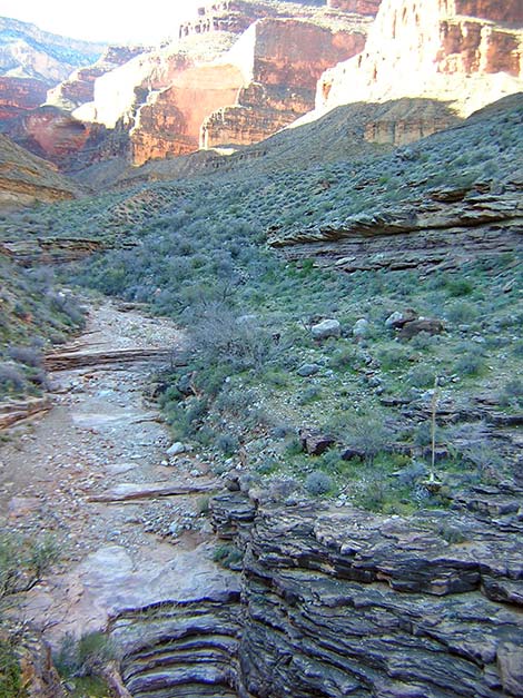
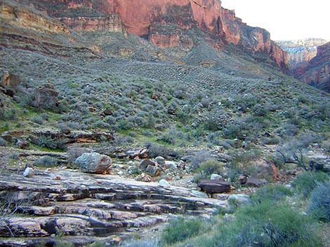 Sapphire Wash (view SE) |
Overview This description of the Tonto West Trail is divided into two parts: (1) an overview of the entire trail, trailheads, and other general information, and (2) individual canyon-to-canyon segments. From the wash in Sapphire Canyon, it is about 2.7 miles and 1.5 hours to the wash in Turquoise Canyon. Seasonal water is available in Sapphire Wash, and springs and seasonal water provide water in Turquoise Canyon. This segment of the trail runs out of Sapphire Canyon, runs northwest along the Inner Gorge passing below Castor Temple, and then runs back into Turquoise Canyon. The trail is always faint, but except for one spot getting out of Sapphire, there is a good, easy, well-cairned route all the way from Sapphire Wash to Turquoise Wash. This segment of the trail is in Backcountry Use Zone BO9 (at-large camping). Link to map of this segment. |
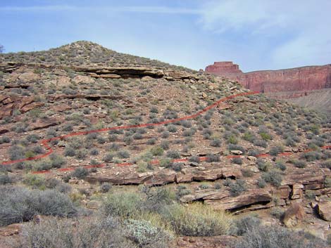 Route past rubble pile (view N) Note: solid line = trail; dashed line = off route trail |
Watch Out Other than the standard warnings about hiking in the desert, ...be sure to read the Watch Out section on the Tonto West Overview page, which discusses things such as cell phones and signal mirrors. While hiking, please respect the land and the other people out there, and please try to Leave No Trace of your passage. Getting to the Trailhead Trailhead information is presented on the Tonto West Overview page. |
 Sapphire Canyon and N Rim from saddle exiting Sapphire (view NW) |
The Hike 13. Sapphire Canyon to Turquoise Canyon -- 2.7 miles and 1.5 hours From the wash crossing in Sapphire Canyon (Table 13, Waypoint 074), the trail west stays above the Tapeats sandstone cliffs and generally runs on the contour. This part of the trail is good and easy to follow. About 15 minutes from the back of the canyon, the trail starts into the only large side canyon on the west side of Sapphire (Wpt. 075). Stop on the corner of the side canyon and get your bearings because the trail takes an odd jog that could throw you off route. From the corner, look north across the side canyon and locate the low, white cliffs with a cave and rubble pile that looks like mine tailings (Wpt. 076). The trail cuts up and across the slope, touching the bottom of the rubble pile. |
 Faint trail through blackbrush (view W) |
From the corner (Wpt. 075), the trail runs into the wash at the back of the side canyon. By the time you get to this point on the Tonto, the trail will have trained you to look across washes to locate the trail on the other side before you get down into the wash. At this wash crossing, an old and mostly obscure trail (shown on the USGS topo map) ran straight across the wash on the contour. Now however, from the bottom of the wash, turn and walk up the wash for a few yards to cairns and a trail leading up and across the sidehill, touching the bottom of the rubble pile below the cave (Wpt. 076). On this rocky hillside, it is hard to see the trail from below. A rocky trail runs up and across the rocky hillside to climb above the band of white cliffs. From there, a good, easy trail runs out to a low saddle with a campsite (Wpt. 077). |
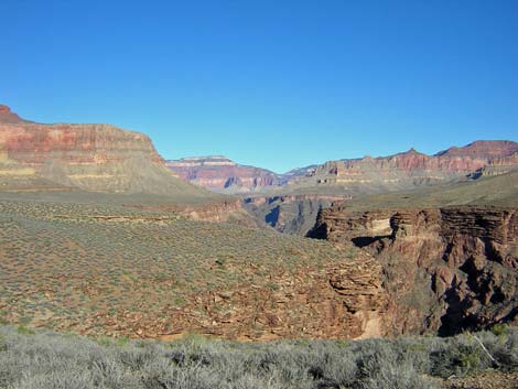
 Turquoise Canyon (view SW) |
From the low saddle (Wpt. 077), a good trail runs north across gentle flats and turns out of the Sapphire Canyon drainage system (Wpt. 078). The trail is faint, but easy to follow. The trail continues northwest across some rocky sideslopes above the river before crossing another broad saddle with a campsite (Wpt. 079) and turning into the Turquoise Canyon drainage system. Crossing the high point into Turquoise (Wpt. 079), the trail is quite faint; watch for the few cairns. This is one place where I thought I lost the trail, but then realized that I was still standing on it. |
 Turquoise Wash crossing (view SW) |
From the high point (Wpt. 079), the trail turns into Turquoise Canyon, running west and then southwest. The trail crosses a sideslope and runs into the back of a side canyon, then curves northwest and climbs onto a small saddle behind a knob (Wpt. 080). The trail here is faint and obscure; watch carefully for cairns leading through the blackbrush. You would expect the trail to continue across saddle, but it curves to the right and runs around the north side of the knob. From the west side of the knob, the moderately cairned trail runs west down the broad ridgeline towards the edge of Turquoise Canyon. The trail runs out onto the top of a band of cliffs at the edge of Turquoise Canyon where an unusually large cairn sits atop a rocky point on the edge of broken cliffs (Wpt. 081). From the large cairn (Wpt. 081), the trail drops through the broken cliffs on a steep, rocky hillside, then picks up the good trail that can be seen on the flats below. Getting through the breakdown is an easy scramble, and a bit of a trail runs quite close to the edge of the abyss. |
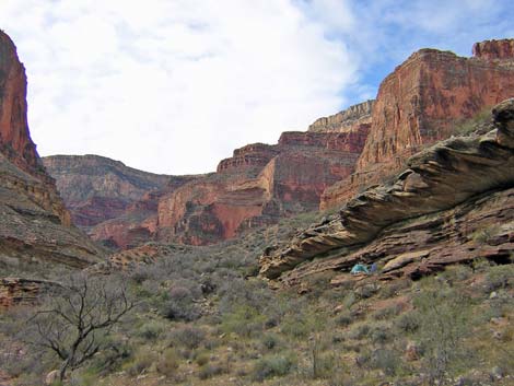 Campsite in Turquoise Canyon (view SW) |
After descending the rocky hillside, the trail into the back of the canyon is well cairned, easy to walk on, and easy to follow. The trail stays close to the edge of the canyon all the way back, and the last bit of trail before the wash crossing runs through the Tapeats cliffs on a narrow trail overlooking Turquoise gorge. The trail crosses Turquoise Wash (Wpt. 082) atop a big sandstone pour-over and just below a little cascade. Note: if you are hiking east from Turquoise Wash, the trail starts by going east up a ravine in a side canyon for a few feet to a little cascade. The trail then cuts north under the band of cliffs and runs out along the edge of Turquoise Canyon. There are cairns, but it is easy to miss the turn and go too far up the ravine. |
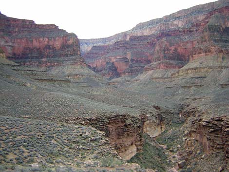
 Turquoise Canyon (view NE) |
Water and campsites are available here. There is a deep, spring-fed pothole at the base of the band of cliffs that form a pour-over about 100 yards upstream from the crossing (Wpt. XX2). The water is dark and full of bugs, so it must be good. There are also puddles fed by clear-water seeps just below the main pothole. I also found good water in potholes in the canyon just below the trail crossing. In addition, there is another spring about a ten-minute walk (0.3 miles) down the canyon (Wpt. XX3). A small creek flows from seeps in the lower Tapeats layer. Saltcedar thickets line the wash in places, and there is a nice fern grotto. There are several campsite options. Just west of the creek crossing, the trail runs through a flat area that is suitable for camping. There are also nice sites on ledges beneath overhanging rocks on the west side of the canyon, as well as sites atop the band of cliffs above the dark-water spring. |
Table 13. Hiking Coordinates Based on GPS Data (NAD27; UTM Zone 12). Download Entire Route Waypoint (gpx) file.
| Wpt. | Location | Time | Easting | Northing | Elevation (ft) | Verified |
|---|---|---|---|---|---|---|
| 074 | Sapphire Wash (47) | 0820 | 383113 | 3999594 | 3,044 | GPS |
| 075 | First major side canyon (48) | 0833 | 383257 | 3999977 | 3,101 | GPS |
| 076 | Cave with rubble (48.5) | 0838 | 383281 | 4000102 | 3132 | GPS |
| 077 | Small saddle with campsite (49) | 0843 | 383307 | 4000348 | 3,213 | GPS |
| 078 | Turn out of Sapphire Canyon on gentle flats (49.5) | -- | 383316 | 4000538 | 3,220 | Map |
| 079 | Turn into Turquoise Canyon (50) | 0900 | 382791 | 4000931 | 3,210 | GPS |
| 080 | Small saddle behind knob (51) | 0912 | 382277 | 4000837 | 3,176 | GPS |
| 081 | Cairn atop broken cliffs (52) | 0916 | 382082 | 4000917 | 3,131 | GPS |
| 082 | Turquoise Wash (53) | 0948 | 381067 | 4000436 | 2,978 | GPS |
| XX2 | Upper Turquoise Spring (53.3) | -- | 381020 | 4000400 | 2,980 | Map |
| XX3 | Lower Turquoise Spring (53.6) | -- | 381400 | 4000695 | 2,840 | Map |
Happy Hiking! All distances, elevations, and other facts are approximate.
![]() ; Last updated 240326
; Last updated 240326
| Hiking Around Grand Canyon | Hiking Around Las Vegas | Glossary | Copyright, Conditions, Disclaimer | Home |