Red Canyon to Mineral Canyon
Hiking Around Las Vegas, Grand Canyon National Park

Overview | Next Segment West | Next Segment East
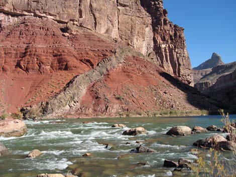 Hance Rapids (view NE) |
Overview I've organized my description of the Tonto East Trail into two parts: (1) an overview of the entire trail, trailheads, and other general information, and (2) individual canyon-to-canyon segments. The segment from Red Canyon to Mineral Canyon (east to west) is described here. From Hance Rapids at the confluence of Red Canyon and the Colorado River, it is about 2.5 miles and 1.75 hours to the wash crossing in Mineral Canyon. Water is available only at Hance Rapids. This segment of the trail climbs from the river to the Tonto Plateau and is fairly strenuous and rocky in places, but it provides many grand views. There is one precarious spot on a narrow ledge where hikers duck low to get under an overhang; some people crawl across this section and drag their pack along the trail. Red Canyon and the Hance Rapids sand dunes are in Backcountry Use Zone BD9 (camping at-large), and Mineral Canyon is in Zone BE9 (camping at-large). Link to map of this segment. |
 West end of the dunes (view W) |
Watch Out Other than the standard warnings about hiking in the desert, this is a fairly safe hike, but there is one particularly narrow section of trail, and there are many places to fall into the abyss. Be sure to read the Watch Out section on the Tonto East Overview page, which discusses things such as cell phones and signal mirrors. While hiking, please respect the land and the other people out there, and please try to Leave No Trace of your passage. Getting to the Trailhead Trailhead information is presented on the Tonto East Overview page. |
 Hance Rapids: looking back from rocky hillside (view E) |
The Hike 1. Red Canyon to Mineral Canyon -- 2.5 miles and 1.75 hours From the confluence of Red Canyon and the Colorado River (Waypoint 001; 1136 hrs), two trails lead west down the river. One trail starts above the Honey Mesquite-covered sand dunes (traditional campsites), while the other starts below them near the edge of the river. Starting from camp, it would be easier to use the upper trail; while starting at the rapids, it would be easier to use the lower trail. The lower trail runs across the base of the sand dunes almost to the far end of the sand (1143), then starts up and across the sand following cairns. |
 Rocky hillside: trail climbs to east edge of boulder field (view W) |
Both trails converge on the rocky hillside about 10 minutes (1147) west of the sand dunes. The junction is not obvious because a few feet of the hillside below the trail is falling away. The trail continues making a fairly difficult traverse across the rocky hillside with many little ups-and-downs, although the overall grade averages to fairly gentle. The rocky hillside gives way to a broad, flat bench (1200). Parts of the trail are hard to follow across here, but there are many cairns. The trail then climbs steeply onto another bench (1212), this one covered with a field of enormous boulders. There is a campsite suitable for a couple of tents (Wpt. 002) at the east end of the boulder field. The trail winds among the boulders and out onto flats, then cuts steeply up a red slope, the top of which (1223) marks the end of the hardest part of the hike between Red Canyon and Mineral Wash. |
 West edge of boulder field (view W) |
From the top of the red slope, the trail cuts across the slope, and when turning a little corner onto steeper slopes, there is a suitable campsite for two tents (Wpt. 003) on the ridge below the trail. The trail runs up onto a narrow ledge system in a layer of shale just before turning into Mineral Canyon, and at the narrowest spot, an overhang rock forces all but the most nimble backpackers onto their knees. Some people crawl across this section and drag their pack along the ground. Neither words nor pictures can do justice to this scene: stepping across the chasm and looking down at the swirling river with the roar of the river filling your ears, and suddenly your backpack bumps something hanging down. Unforgettable. Note from voice recorder: “We took pictures at the narrow spot, but they do not do justice to the scene if you can’t look down to the river and hear it roaring below you.” |
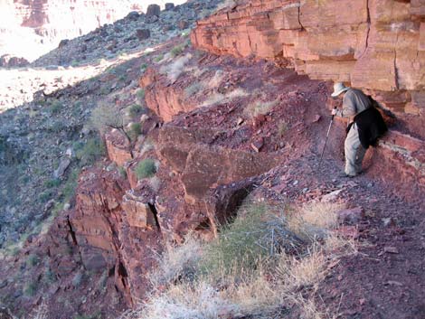 After coming through, hiker looks back at the crawl space (view E) |
Past the low overhang, the trail widens somewhat and quickly turns into Mineral Canyon (Wpt. 004; 1229). The views from the point are spectacular. The broad canyon, red rocks, and green rapids upstream; and the narrow, black gorge and dark-colored water downstream. The trail more or less follows the ledge system in the shale uphill and south at a moderate grade for about 30 minutes to a point (1256) where the dip changes from up to down. Starting out, there are some narrow sections, and about half-way out, there is a bit of a scramble up across a crumbly layer of shale (short bit of 2nd-class) at the trail moves from one ledge system to a higher one. |
 Mineral Canyon (view S) |
From the point, the trail runs down along shale ledges until working up and down across the hillside. The trail passes below a 12-foot-thick band of interesting conglomerate rock, then climbs somewhat steeply and turns into a rocky side canyon. There is a nice big campsite (1308) near the back of the side canyon on the south side. From the campsite, the trail winds out of the side canyon and runs down towards Mineral Wash. The trail drops over a steep cutbank into Mineral Wash (Wpt. 006; 1315), runs down the wash for about 20 yards, then cuts up the bank on the other side. There are no campsites at the wash crossing, but there are two poor campsites up the trail about 100 yards up the trail on the west side of the wash. |
 ledges in Mineral Canyon (view S) |
 Looking back at hiker on ledges in Mineral Canyon (view N) |
 Trail on hillside in Mineral Canyon (view S) |
 Looking back at Mineral Canyon (view N) |
Table 1. Hiking Coordinates Based on GPS Data (NAD27; UTM Zone 12). Download Entire Route Hiking GPS Waypoints (*.gpx) file.
| Wpt. | Location | Easting | Northing | Elevation | Point-to-Point Time (min) | Cumulative Time (min) | Point-to-Point Distance (mi) | Cumulative Distance (mi) | Total Tonto Distance (mi) |
|---|---|---|---|---|---|---|---|---|---|
| 01 | Mouth of Red Canyon | 417186 | 3989146 | 2,546 | 0:00 | 0:00 | 0.00 | 0.00 | 0.00 |
| 02 | Campsite in boulder field | 415965 | 3989091 | 2,939 | 0:43 | 0:43 | 1.14 | 1.14 | 1.14 |
| 03 | Turning a little corner | 415651 | 3988974 | 3,015 | 0:09 | 0:52 | 0.28 | 1.42 | 1.42 |
| 04 | Turning out of Mineral Canyon | 415539 | 3988925 | 3,058 | 0:06 | 0:59 | 0.12 | 1.54 | 1.54 |
| 05 | Campsite | 415595 | 3987847 | 3,374 | 0:31 | 1:30 | 1.04 | 2.58 | 2.58 |
| 06 | Crossing Mineral Wash | 415352 | 3987622 | 3,359 | 0:10 | 1:40 | 0.31 | 2.89 | 2.89 |
Happy Hiking! All distances, elevations, and other facts are approximate.
Total Tonto Distance (mi) starts at the mouth of Red Canyon.
![]() ; Last updated 240326
; Last updated 240326
| Hiking Around Grand Canyon | Hiking Around Las Vegas | Glossary | Copyright, Conditions, Disclaimer | Home |