Basin and Range National Monument, Rock Art Around Las Vegas
Rock art is a precious resource. Please help protect and preserve these sites.
 Hwy 318 at Old White River Narrows Road (view E) |
Overview The White River Narrows Archeological District, located in Basin and Range National Monument, is an area of outstanding petroglyphs that is listed on the National Register of Historic Places. The White River cut a narrow canyon through light-colored volcanic rock (rhyolite), providing a series of desert-varnished and unvarnished rock panels on which the ancients etched and painted representational (e.g., bighorn sheep and human figures) and abstract images. Unfortunately, vandals added their marks, too (some photos were edited to deny vandals the publicity they seek). The BLM and Lincoln County opened this area to the public. The BLM printed a single-sheet flier, and Lincoln County printed a 55-page brochure with information about the site (including GPS coordinates) as part of their Get Primitive tourism campaign. Download the brochure from Lincoln County or snatch a copy here. A newer guide (4MB PDF) is also available (or here). Stay off unpaved roads if they are muddy. Link to Map. |
 Fork in the road at 0.15 miles out (view NE) |
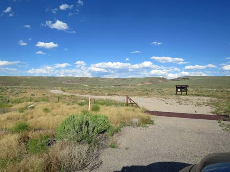
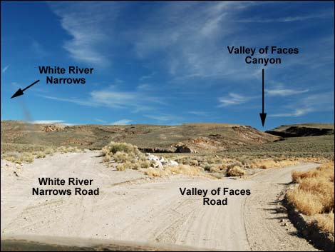
Location The White River Narrows Archeological District is located beyond the Pahranagat Valley about 131 miles north of Las Vegas on Highway 318. From town, drive north on Interstate 15 to US Highway 93 (Table 1, Site 0674). Exit onto Highway 93 and drive north past Alamo and Ash Springs to the intersection of Highway 93 and Highway 318 (Site 0677; about 110 miles out). In this area, gasoline is available in Alamo, Ash Springs, Rachel, and Lund. Turn left onto Highway 318 and drive west then north for 23.8 miles to White River Narrows Road on the right. In about 0.15 miles, the dirt road forks. Staying left, White River Narrows Road runs out to three of the petroglyph sites; staying right, Valley of Faces Road runs out to two other sites. |
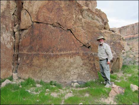 |
White River Narrows Road, Calendar Fence Site Calendar Fence Site is a small site composed of one long horizontal line with a multitude of short vertical lines rising up from the horizontal line. There are a couple of other marks on the stone, but they might be recent additions, and there are no other petroglyphs in the immediate area. |
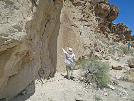 |
White River Narrows Road, Martian Home Site Martian Home is a small site composed of one well-marked panel and one ancillary petroglyph. The artwork here is unusual because the rock wall is not varnished, and so native peoples just carved their marks into the relatively soft stone. The glyphs here are unusual too in that they largely depict oval figures with various bands and antennae. |
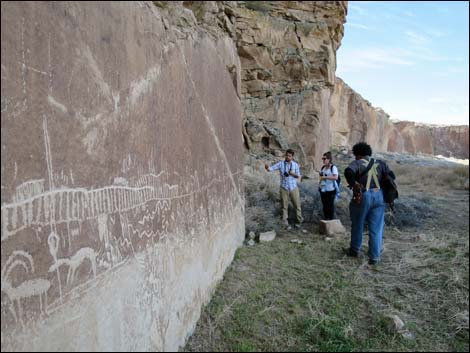 |
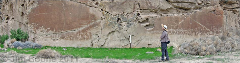
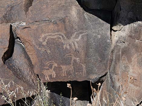
White River Narrows Road, Amphitheater Site Amphitheater is the major site in this area and is composed of three well-marked panels and several ancillary petroglyph panels. The artwork here includes unvarnished carved stone and typical petroglyphs pecked into desert varnish. Unfortunately, the panels here have been badly marked by vandals. |
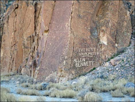 |
Modern people have added their marks to the walls. While some of these are old and represent early white settlement of the area, let's be sure to leave the rock walls as we find them. Some of these names have been removed by restoration crews. |
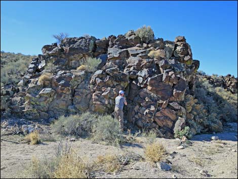 |
Valley of Faces Road, Cane Site A Cane Site A is a small site composed of boulders on the end of a small rockpile. Many of the boulders are marked, including some near the top. The petroglyphs here are mostly abstract, but a few are representational. |
 |
Site 4 is a small site composed of an isolated rock wall. Many of the rock faces are marked. The petroglyphs here are mostly abstract, but a few are representational. |
 |
Valley of Faces Road, Ash Hill Site Ash Hill Site is a small site composed of petroglyphs carved into an unvarnished cliff. The petroglyphs here are entirely abstract, the main glyph of which is a long line of dots. |
Table 1. Highway Coordinates based on GPS data (NAD27; UTM Zone 11S). Download Highway GPS Waypoints (*.gpx) file.
| Site # | Location | UTM Easting | UTM Northing | Latitude (N) | Longitude (W) | Elevation (ft) |
|---|---|---|---|---|---|---|
| 1105 | Hwy 318 at Wt River Narrows Rd | 670994 | 4187415 | 37.81998 | 115.05729 | 4,471 |
| 1106 | White River Narrows Rd Fork 1 | 671191 | 4187421 | 37.82000 | 115.05505 | 4,440 |
| 1107 | White River Narrows Rd Fork 2 | 671347 | 4187392 | 37.81971 | 115.05328 | 4,440 |
| 1108 | White River Narrows Rd Fork 3 | 671956 | 4187537 | 37.82091 | 115.04633 | 4,509 |
| 1109 | White River Narrows Rd Fork 4 | 672453 | 4187644 | 37.82177 | 115.04066 | 4,496 |
| 1110 | White River Narrows Rd Fork 5 | 672518 | 4188436 | 37.82890 | 115.03974 | 4,523 |
| 1111 | White River Narrows Rd End | 672607 | 4189044 | 37.83436 | 115.03857 | 4,561 |
| 1112 | Wt River Alt Rd Petro 1 | 671953 | 4187166 | 37.81756 | 115.04646 | 4,494 |
| 1113 | Wt River Alt Rd Fork | 671995 | 4187090 | 37.81687 | 115.04599 | 4,527 |
| 1114 | Wt River Alt Rd Petro 2 | 671748 | 4187195 | 37.81786 | 115.04877 | 4,503 |
Table 2. Hiking Coordinates based on GPS data (NAD27; UTM Zone 11S). Download Hiking GPS Waypoints (*.gpx) file.
| Wpt. | Location | UTM Easting | UTM Northing | Elevation (ft) |
|---|---|---|---|---|
| 01 | Wt River Narrows Register | 672607 | 4189039 | 4,550 |
| 02 | Amphitheater Site | 672488 | 4188999 | 4,555 |
| 03 | Martian Home Site | 672347 | 4188435 | 4,516 |
| 04 | Calendar Fence Site | 672478 | 4187572 | 4,494 |
| 05 | Ash Hill Site | 671990 | 4187155 | 4,512 |
| 06 | Cane Site A | 671747 | 4187188 | 4,495 |
| 07 | Site 4 | 671747 | 4187315 | 4,478 |
Happy Hiking! All distances, elevations, and other facts are approximate.
![]() ; Last updated 240324
; Last updated 240324
| Rock Art | Glossary | Copyright, Conditions, Disclaimer | Home |