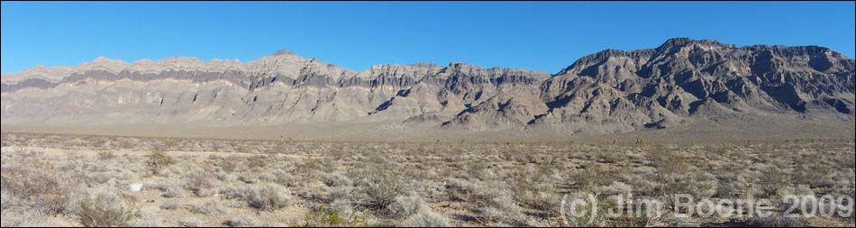
OVERVIEW The Arrow Range is a long, north-south orientated ridge and string of peaks that is a striking example of the fault-block topography typical of the Great Basin. On the west side of the range, the fault scarp rises sharply from the valley floor for nearly 3,000 feet, exposing numerous layers of gray and black carbonate rocks (limestone and dolomite) and at least two layers of white quartzite. From Highway 93, you can see several sub-faults where layers of carbonates and quartzite don't line up properly and where entire blocks of the mountain seem to have slipped down the face. The east side of the range rises less steeply, but it is cut by several deep canyons. Arrow Canyon, located on the east edge of the range, is a deep, narrow slot canyon described by one old-time field geologist as the most amazing slot canyon in all of Nevada. |
|
Activities in the Arrow Range primarily are orientated around day-hiking. People also backpack, ride horses, ORV, and hunt in the area. The northern part of the range (27,500 acres) was designated as a wilderness area in October 2002, so vehicles are prohibited from that area. The Arrow Range is located in the Mojave Desert, but the higher elevations show biotic influences from the Great Basin. Elevations range from about 2,000 feet in the valleys to 5,226 feet at the highest peak. The lower-elevation desert-scrub areas are dominated by scattered creosote bush, bursage, lizards, and a few desert tortoises; the middle elevations are floristically diverse with shrubs, forbs, cacti, and yucca; and the higher elevations are dominated by blackbrush and bighorn sheep. The variation in topography and soils makes for a mix of habitats and a diverse flora and fauna. Canyons along the eastern edge of the range support ash trees and mesquite thickets. |
|
Temperatures in the lower-elevation areas are similar to those in Las Vegas: daytime summer temperatures can exceed 100 degrees, while daytime winter temperatures can stay below freezing. The higher-elevation areas are cooler, but summer temperatures can still exceed 90 degrees. Because of the high summer temperatures, hiking is best during October through May. Afternoon thunderstorms are common during July and August, possibly creating flash flood and lightning hazards. There are no services in the Arrow Range. While hiking in the Arrow Range, and especially in the Arrow Canyon Wilderness Area, please respect the land and the other people out there, and please try to Leave No Trace of your passage. There are few cairns in the range; please don't leave any new ones. Also, this area has many long hard hikes, so choose routes of the appropriate difficulty, and be sure to bring the 10 Essentials. |
|
GETTING TO THE ARROW RANGE The Arrow Range is located about 45 minutes northeast of Las Vegas, north of Interstate-15 and east of Highway 93. To get to the west side of the Arrow Range from Las Vegas, drive north on Interstate-15 for about 20 minutes to Highway 93 (Exit 64) (Table 1, Site 674). Turn left onto Highway 93 and drive north for about 20 miles. Stop on the side of the highway adjacent to the Arrow Range (for example, Site 876). Be sure to park well off the pavement. The Highway Patrol probably will check your vehicle while you are away, so when you return, expect to find a notice on your antenna about abandoned vehicles. If you are backpacking, you probably should leave a note for the officer so they don't tow it away. |
|
To get to the east side of the range from Las Vegas, there are two choices: (1) drive around the south end on the interstate or (2) drive around the north end on the scenic route. 1. Fast Route. From town, drive north on Interstate-15 for about 30 minutes to the Moapa-Glendale exit (Exit 90) (Site 879). Exit the Interstate and drive north on Highway 168 to the north end of the Warm Springs Valley and the intersection with Warm Springs Road (Site 878). 2. Scenic Route. From town, drive north on Interstate-15 for about 20 minutes to Highway 93 (Exit 64) (Site 674). Exit the Interstate and drive north on Highway 93 for about 30 minutes (30.8 miles) to Highway 168 (Site 877). Turn right onto Highway 168 and drive east around the north edge of the Arrow Range. Continue east to the intersection with Warm Springs Road (Site 878). |
|
HOURS Always open. ENTRANCE FEES None. CAMPING There are no campgrounds in the Arrow Canyon Range, but dispersed camping is allowed along roads outside the wilderness area. Backcountry camping is unregulated. Backpackers can camp anywhere in the backcountry. Backcountry permits are not required. Don't camp in washes because of the danger of flash floods. Don't plan on having wood fires. Don't camp near water because it prevents thirsty animals from coming in for water. HIKING The Arrow Canyon Range provides a plethora of hiking opportunities ranging from deep narrow canyon, to exposed rocky ridges, and everything between. Several hikes are described on the Arrow Canyon Range Hiking webpage. |
|
 |
WATCH OUT Other than the standard warnings about hiking in the desert, ...the Arrow Range is a wild and rugged place with lots of loose rock, steep and exposed gullies, and water-polished waterfalls. Be careful climbing and don't knock rocks on your hiking partners. The Arrow Range is open for hunting, and it is always open season for something. During July and August, afternoon thunderstorms are common. Lightning is a hazard in exposed places and on ridges, and flash floods are a hazard in narrow canyons. Summer temperatures can exceed 110 degrees, and there is little (if any) shade, so mid-day hiking should be avoided. Ticks generally are rare in southern Nevada, but they seem to be common in portions of the Arrow Range, so be sure to check your clothing and your skin for these unwelcome hitchhikers. The species of ticks here, Dermacentor hunteri, are most active in the fall and winter. In case of emergency, call 911. Cell phones work along Highway 93 and from the crest of the range, but don't count on it. There are no public phones. |
SOME RULES AND REGULATIONS Resource Protection. The wilderness portion of the Arrow Range is regulated similar to National Parks. Don't collect or otherwise disturb plants, rocks, fossils, historical objects, or artifacts, and don't feed or disturb the wildlife. Collecting wood for campfires, including dead and down wood, is not a good idea because it prevents the small amount of wood out there from decaying and providing nutrients and organic matter to the soil. Pets. Pets probably are allowed everywhere in the range, including the backcountry. Never leave your pet in a vehicle because temperatures inside a car parked in the sun can exceed 120 degrees in just a few minutes, quickly cooking your pet (ditto for kids). Vehicles and Bicycles. No driving or biking in wilderness areas. FOR MORE INFORMATION Call the BLM (702-515-5000) or visit their website. |
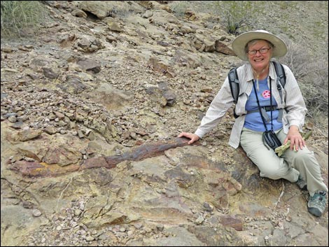 Happy lady with fossilized Lepidodendron root |
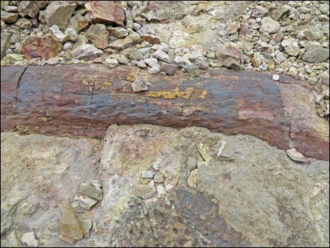 Fossilized Lepidodendron root |
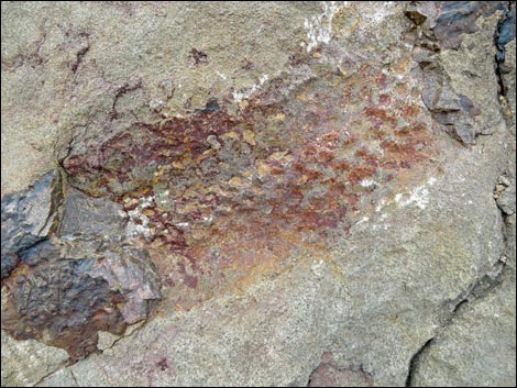 Root and surface texture of Lepidodendron fossil |
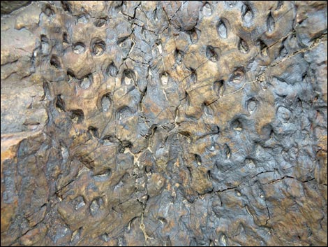 Surface texture of Lepidodendron fossil |
Table 1. Highway Coordinates (NAD27; UTM Zone 11S).
| Site # | Location | Latitude (°N) | Longitude (°W) | UTM Easting | UTM Northing | Elevation (feet) | Verified |
|---|---|---|---|---|---|---|---|
| 674 | I-15 at Hwy 93 | 36.3809 | 114.8909 | 689188 | 4028063 | 2,232 | Yes |
| 876 | Hwy 93 at Big Arrow trailhead | 36.6494 | 114.9196 | 685970 | 4057799 | 2,659 | Yes |
| 877 | Hwy 93 at Hwy 168 | 36.7993 | 114.9458 | 683266 | 4074374 | 2,532 | Yes |
| 878 | Hwy 168 at Warm Springs Rd (north end) | 36.7376 | 114.7363 | 702121 | 4067952 | 1,831 | Yes |
| 879 | I-15 at Hwy168 (Glendale) | 36.6606 | 114.5734 | 716889 | 4059763 | 1,542 | Yes |
Happy hiking! All distances, elevations, and other facts are approximate.
![]() ; Last updated 240322
; Last updated 240322
| Hiking Around Las Vegas | Glossary | Copyright, Conditions, Disclaimer | Home |