| Views Around Las Vegas based on Google Earth images. Point of View is about 150 feet above the Spaghetti Bowl (intersection of Interstate 15 and Highway 93/95), which is essentially downtown Las Vegas. |
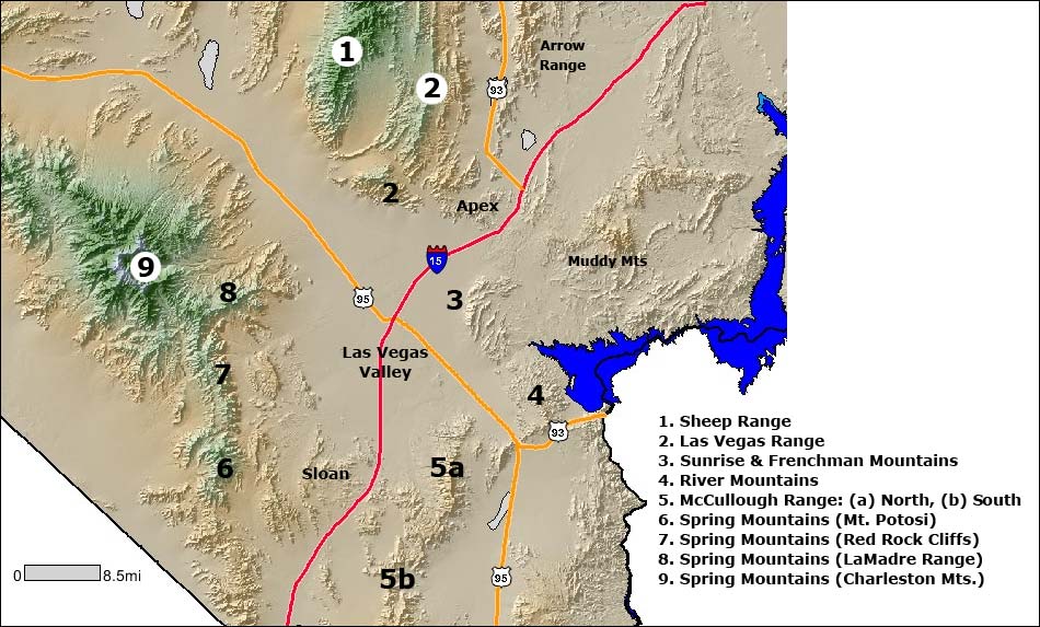
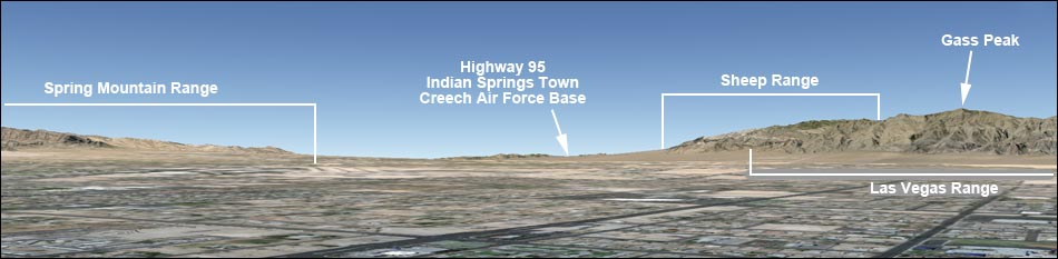
 North. The Sheep Range (1) and Las Vegas Range (2) form the north edge of the Las Vegas Valley. The Sheep Range runs north-south between Highways 95 and 93. The Las Vegas Range runs east-west along the north edge of town. Both of these mountain ranges, plus four more are on the Desert National Wildlife Range, a national wildlife refuge. |
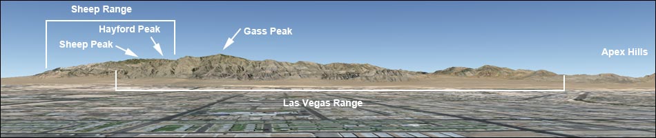
 Northeast. The Las Vegas Range (2), Apex Hills, Muddy Mountains (in the distance), and Sunrise Mountains (3) form the northeast edge of the Las Vegas Valley. The Muddy Mountains are out between Interstate 15 and Lake Mead. The Las Vegas Range is part of the Desert National Wildlife Range, and the Muddy Mountains are in the Muddy Mountains Wilderness Area. |
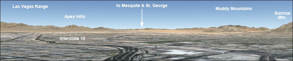
 East. The Sunrise-Frenchman Mountains (3) and the River Mountains (4) form the east edge of the Las Vegas Valley. On a clear day, Virgin Peak (out near Mesquite), some of the peaks in southwest Utah, peaks beyond the Overton Arm of Lake Mead, and Wilson Ridge (Arizona) can be seen from the west side of the Las Vegas Valley. This view includes areas accessible from the Lake Mead National Recreation Area. |
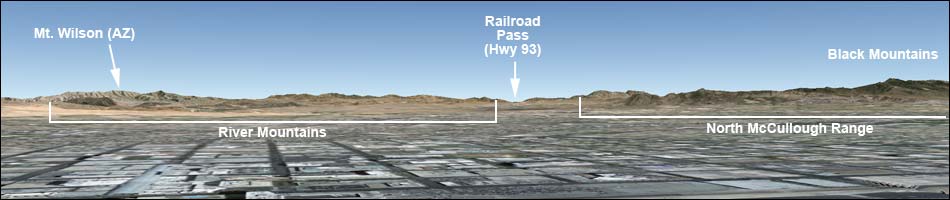 Southeast. The River Mountains (4) and North McCullough Mountains (5a) form the southeast edge of the Las Vegas Valley. This view includes areas accessible from the Lake Mead National Recreation Area and area in the Sloan Canyon National Conservation Area and the North McCullough Wilderness Area. |
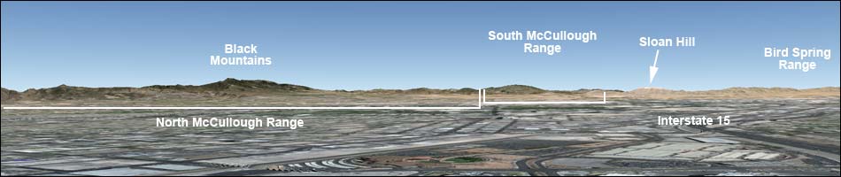 South. The North McCullough Range (5a), South McCullough Range (5b; in the distance) Sloan Hills, and Bird Spring Range form the south edge of the Las Vegas Valley. This view includes the Sloan Canyon National Conservation Area, the North McCullough Wilderness Area, and the South McCullough Wilderness Area. |
 Southwest. The South McCullough Range (5b; in the distance), Sloan Hills, Bird Spring Range, and the south end of the Spring Mountain Range (Mt. Potosi, 6) form the southwest edge of the Las Vegas Valley. This view includes the South McCullough Wilderness Area and part of Red Rock Canyon National Conservation Area. |
|
|
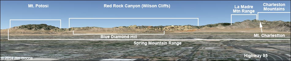
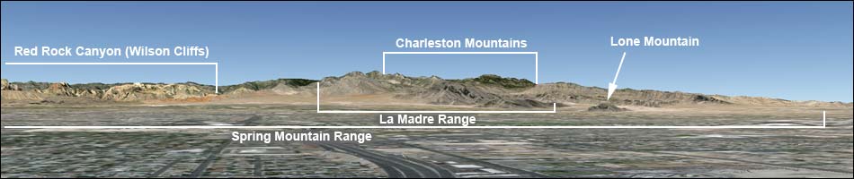
 North-Northwest. The Spring Mountain Range (Charleston Mountains (9)) and the Sheep Range (1) form the northwest edge of the Las Vegas Valley. This view includes the Spring Mountains National Recreation Area and the Desert National Wildlife Range. Highway 95 runs through the valley between these two mountain ranges. |
Closer Photos and Different Angles
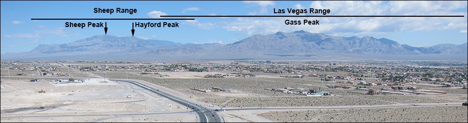 1 and 2. Desert National Wildlife Range, Sheep Range and Las Vegas Range. North edge of the Las Vegas Valley. The Sheep Range runs north-south between Highways 95 and 93. The Las Vegas Range runs east-west along the north edge of town. Photo taken from Summerlin, just south of the Summerlin Parkway. View north. |
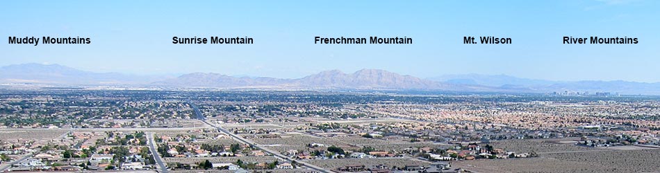
3. Lake Mead Region, Muddy Mountains and Sunrise-Frenchman Mountains. East edge of the Las Vegas Valley. Muddy Mountain is out between Interstate 15 and Lake Mead. On a clear day, from here you can see Virgin Peak (out near Mesquite), some of the peaks in southwest Utah, and peaks beyond the Overton Arm of Lake Mead. The ridge on the right edge of the photo is the toe of Wilson Ridge, which is in Arizona south of Lake Mead and east of the dam. Photo taken from Summerlin (Hualapai south of Town Center). View east. |
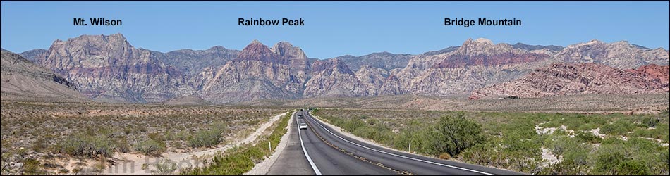
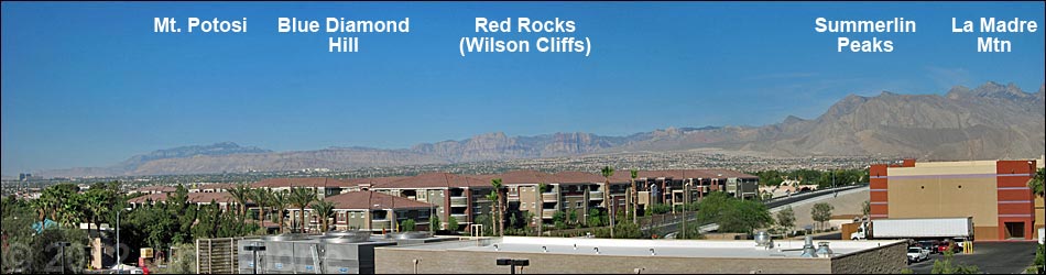
7. Red Rock Canyon NCA, Wilson Cliffs. West edge of the Las Vegas Valley. The northern toe of Blue Diamond Hill can be seen on the left edge of the photo. Blue Diamond Hill blocks most of the view of Red Rocks from town. Photo taken from West Charleston Blvd near the Red Rock Canyon National Conservation Area boundary. View west. |
 West side of Las Vegas. Photo taken from Fiesta Casino parking garage (view southwest) |
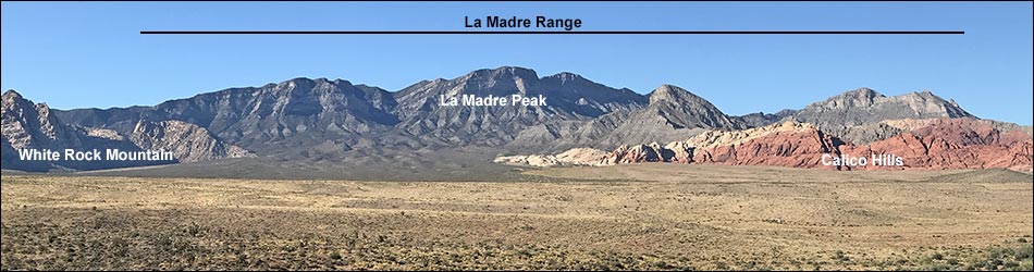
8. La Madre Range. West edge of the Las Vegas Valley (north side of Red Rock Canyon NCA). This is the south side of the range. The red rocks on the right edge of the photo are the Calico Hills; the white rocks on the left edge of the photo is White Rock Peak; the Spring Mountains (Mt. Charleston) are just left of the photo, and the Red Rocks Cliffs are to the left of the photo. Photo taken from West Charleston Blvd at the Scenic Overlook picnic area in the Red Rock Canyon NCA. View north. |

9. Spring Mountains NRA. Northwest edge of the Las Vegas Valley. View looking up Kyle Canyon from the historical Cowboy Trail Rides parking lot (sometimes now referred to as Kyle Canyon Overlook). Griffith Peak, which is the high peak that can be seen from much of Summerlin, is behind Harris Peak in this photo. The north side of the La Madre Range is to the left of the photo. Photo taken from the Kyle Canyon Road. View west. |
Happy Hiking! All distances, elevations, and other facts are approximate.
![]() ; Last updated 240330
; Last updated 240330
| Hiking Around Las Vegas | Glossary | Copyright, Conditions, Disclaimer | Home |