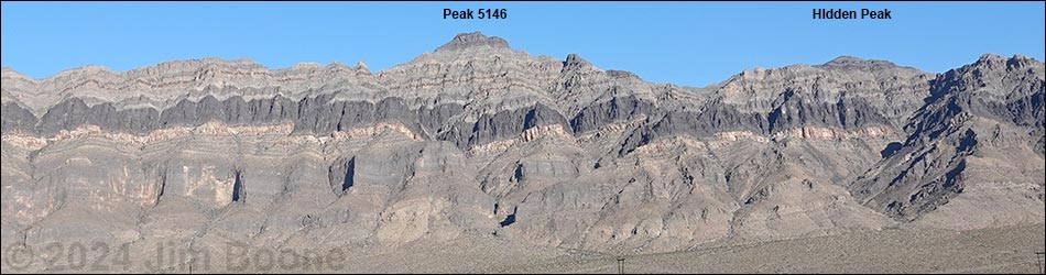
Hiking Around Las Vegas, Arrow Canyon Range, Arrow Canyon Wilderness Area
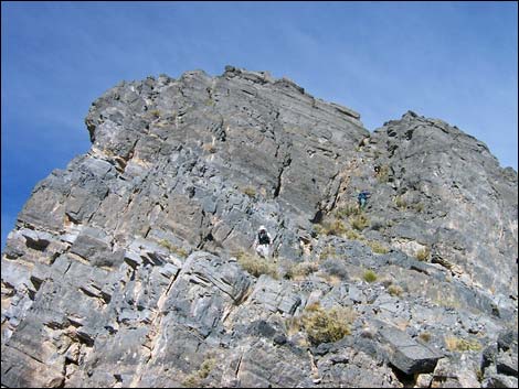
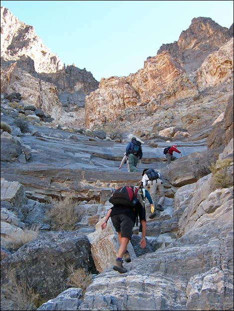 Climbing pour-overs high in the canyon near where the route exits the bottom of the canyon left and starts up steep gullies |
Overview This is a tough 4th-class route that starts in the bottom of the valley and runs up 2,750 vertical-feet to the summit of Peak 5146, one of the highest peaks in the Arrow Canyon Wilderness Area. One long section of 3rd-class climbing, located high on the route, was described by a fellow climber as being a very efficient route -- it was steep and runs straight towards the summit. Just below the summit, there is a 4th-class chute where some climbers might want a belay, especially for the downclimb (with effort, the chute can be avoided). Views from many parts of the route are spectacular, as is the exposure. This route follows obscure gullies, and it is difficult to accurately describe each turn. Therefore, this description relies heavily on the topo map and GPS coordinates, plus the climber's good route-finding abilities. This stout route is not for the inexperienced or faint of heart. Link to map. |
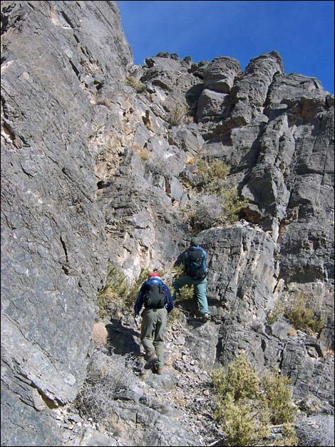
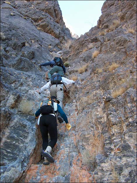 Hikers in the steep gully that runs through the black band |
Watch Out Other than the standard warnings about hiking in the desert, ...this is a hard route with many pour-overs, much loose rock, and lots of steep 2nd-, 3rd-, and 4th-class climbing. A rescue from anywhere between the top of the alluvial fan and the summit ridge would be difficult. This is a wilderness area, so while hiking, please respect the land and the other people out there, and please try to Leave No Trace of your passage. There are few cairns on this route; please don't leave any new ones. Also, this is a long hard hike, so be sure to bring the 10 Essentials. Getting to the Trailhead This hike is located on the west side of the Arrow Canyon Range, about 45 minutes northeast of Las Vegas. From Las Vegas, drive out to the west side of the Arrow Canyon Range. From the intersection of Interstate-15 and Highway 93, drive north on Highway 93 for 23.1 miles. Stop by Mile Marker 75 (Site 0880), well off the pavement. Park here; this is the trailhead. The Highway Patrol probably will check your vehicle while you are away, so when you return, expect to find a notice on your antenna about abandoned vehicles. |
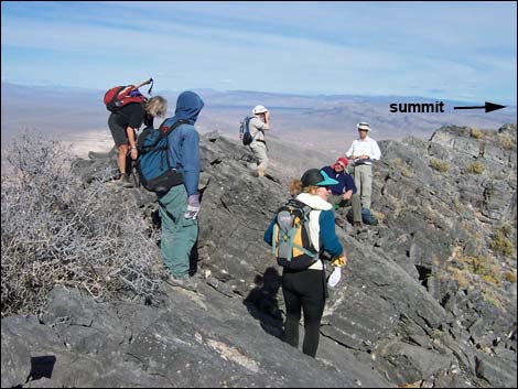
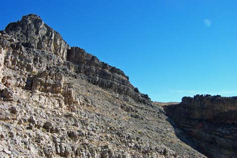 Summit ridge (view E from promontory atop steep gullies) |
The Hike From the trailhead (Table 2, Waypoint 01), the route runs eastward for about 0.8 miles to a powerline road, then continues another 1.1 miles to the mouth of a major canyon (Wpt. 04), the lower end of which comes straight down the face of the mountain about 1,000 yards south of the summit. Another canyon (688000, 4062300; 2,800 ft) empties onto the bajada about 300 yards south of this canyon, but that canyon runs diagonally up and to the southeast. |
 Hikers on the summit ridge below summit block (view N) |
Initially, the walking is easy as hikers wind among vegetation typical of the Mojave Desert, dominated by creosote bush and bursage, but with lots of other species (including yucca and cactus) mixed in. There is also a lot of cryptogamic (biological soil) crust in the bottom of the valley, and to the extent that we can, we should avoid walking on the crust. The crust is a complex mixture of cyanobacteria, green algae, lichens, mosses, microfungi, and other bacteria. The cyanobacteria and microfungi weave a network of filaments through the top few millimeters of soil and exuded polysaccharides that bind loose soil particles together, thereby stabilizing and protecting the soil surface from erosion. The roughened and stabilized surface then provides microsites for lichens and mosses to develop in the spaces between shrubs that otherwise would be bare. The little peaks (1-inch high) in the crust can take centuries to develop. From the mouth of the canyon (Wpt. 04), the route heads east for about 20 minutes (600 yards) to the first major fork in the drainage (Wpt. 05). Passing the lower canyon involves scrambling over and around numerous large boulders, many of which contain fossils (e.g., corals, sponges, crinoids, snails, and nautaloids) that can also be seen higher up in intact rock. From the fork, the route scrambles up the northern (left) canyon. About 400 yards out, progress appears to be blocked by a 30-ft pour-over (Wpt. 06). However, it can be passed with a little 4th-class friction climbing by traversing in from the southern edge of the cliff near the top of the pour-over (viewed from below, climb across the top-right edge of the cliff). It looks worse than it is, as the carbonate rocks are quite rough. This pour-over was a bit high for comfort and probably would be dicey to down climb without a rope (the first step off the top would be the worst). |
 Two hikers on 4th-class summit block (view N) |
Passing the pour-over, the route continues scrambling up the main canyon, climbing more little pour-overs, for about 50 yards to where a steep gully angles up the northern side of the canyon (Wpt. 07). This is below the point where the main canyon angles off to the south (right). From here, cut up and out of the bottom of the canyon, heading for a steep gully that runs up into the band of black rock on the north (left) side of the canyon. Continuing up for about 70 yards, the route gets out of the main gully, climbs more pour-overs, and gets into the steep gully (Wpt. 08). Continuing up for about 100 yards, the route reaches the bottom of a band of quartzite (Wpt. 09). Continuing up for fewer than 5 minutes, the route ascends a short, 3rd-class pour-over just above the quartzite, then continues climbing the gully through the black band (this is the gully described as being very efficient) for about 400 yards to reach a promontory (Wpt. 10). This is the top of the difficult climbing on this part of the route. Relax on the promontory and enjoy the view of the valley; it still is a ways to the summit. |
 Climbing the 4th class gully |
From the promontory (Wpt. 10), the route angles to the southeast and runs down across sloping ledges heading for a saddle on the skyline about 220 yards to the east. Walk down along the broad, rocky ledges, the route climbs through cliffs near the saddle, then crosses a loose scree slope angling into the saddle (Wpt. 11). From the saddle, it is basically a 200-yard walk up and northeast across the summit slopes to the summit ridge (Wpt. 12). The easy walk gives hikers opportunity to enjoy the view. Also notice that the vegetation on the upper slopes is more diverse than lower down. Here there is lots of blackbrush, saltbush, a big species of buckwheat, bunch grasses, ephedra, a few desert almond, a mound cactus with long red spines, and lots of others species. On the summit ridge, the route works north towards the base of the summit block (Wpt. 13), traversing around to the west side of a buttress. Here, easy walking leads to a 30-ft high, 4th-class face that can be climbed easily or passed in a hidden gully a few steps farther to the north. From the base of the summit block, carefully climb the steep 4th-class gully on the southwest corner of the summit block. Most of the climbing is on solid rock, but some is loose. Near the middle of the climb, there are some small, but interesting solution tubes (phreatic tubes) in the rock where water flowed through the rock. Given more time, these might have widened to form a cave. I pulled loose a large rock at the top of the most difficult part of the gully, which is still there, so be careful. |
 Views from near the summit are spectacular (view N) |
From the top of the 4th-class gully, the route heads north towards the summit, which is only a few minutes away. There are two summits that look about equal in height; the USGS topo map marks the northern peak (Wpt. 14) as the summit. The views from the summit are spectacular. To the east lie Mormon Mountain and Moapa Peak, Moapa, the Virgin Mountains, and peaks up in Utah; to the south is the Lake Mead region and the southern parts of the Arrow Range; to the west are the Las Vegas and Sheep Ranges on the Desert National Wildlife Range, and to the north are the remainder of the Arrow Range and numerous mountain ranges beyond. When your spirit has been refreshed and you are ready to depart the summit, there are two basic choices for getting down: (1) downclimb the ascent route or (2) hike south to the summit of Hidden Peak and descend the Hidden Peak route. The second choice makes for a long, but safer way to get down. |
Table 1. Highway Coordinates based on GPS Data (NAD27; UTM Zone 11S). Download highway GPS waypoints (gpx) file.
| Site | Location | UTM Easting | UTM Northing | Latitude (N) | Longitude (W) | Elevation (ft) | Verified |
|---|---|---|---|---|---|---|---|
| 0880 | Hwy 93 at Hidden Peak Parking | 685272 | 4062093 | 36.68827 | 114.92635 | 2,430 | Yes |
| 1602 | Arrow W Powerline Rd at Peak 5146 TH | 686558 | 4062220 | 36.68916 | 114.91193 | 2,415 | Yes |
Table 2. Hiking Coordinates and Distances based on GPS Data (NAD27; UTM Zone 11S). Download hiking GPS waypoints (gpx) file.
| Wpt. | Location | UTM Easting | UTM Northing | Elevation (ft) | Point-to-Point Distance (mi) | Cumulative Distance (mi) | Verified |
|---|---|---|---|---|---|---|---|
| 01 | Trailhead | 685272 | 4062093 | 2,430 | 0.00 | 0.00 | GPS |
| 02 | Bottom of Valley | 686550 | 4062219 | 2,419 | 0.81 | 0.81 | GPS |
| 03 | High on Bajada | 687722 | 4062440 | 2,706 | 0.78 | 1.59 | GPS |
| 04 | Mouth of Canyon | 688145 | 4062583 | 2,844 | 0.31 | 1.90 | GPS |
| 05 | Fork in Canyon | 688731 | 4062561 | 3,104 | 0.42 | 2.32 | GPS |
| 06 | 30-ft Pour-Over | 688996 | 4062809 | 3,419 | 0.28 | 2.60 | GPS |
| 07 | Below Quartzite Band | 689044 | 4062822 | 3,468 | 0.04 | 2.64 | GPS |
| 08 | Base of Chute | 689048 | 4062868 | 3,636 | 0.04 | 2.68 | GPS |
| 09 | Bottom of Quartzite Band | 689084 | 4062949 | 3,775 | 0.07 | 2.75 | GPS |
| 10 | Promontory Ridge | 689339 | 4063133 | 4,606 | 0.31 | 3.06 | GPS |
| 11 | Saddle | 689557 | 4063096 | 4,685 | 0.16 | 3.22 | GPS |
| 12 | Summit Ridge | 689597 | 4063293 | 4,890 | 0.14 | 3.36 | GPS |
| 13 | Base of Summit Block | 689604 | 4063410 | 4,933 | 0.09 | 3.45 | GPS |
| 14 | Summit Peak 5146 | 689604 | 4063541 | 5,146 | 0.10 | 3.55 | GPS |
Happy Hiking! All distances, elevations, and other facts are approximate.
![]() ; Last updated 241002
; Last updated 241002
| Arrow Canyon Range | Hiking Around Las Vegas | Glossary | Copyright, Conditions, Disclaimer | Home |