Southern Nevada Wilderness Areas
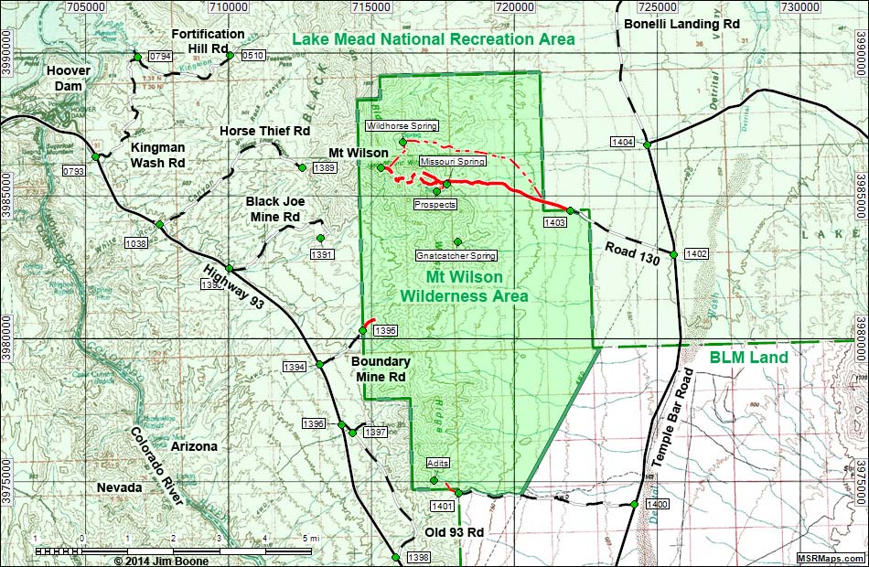
Note: Roads are black (solid = paved; dashed = unpaved). Trails and routes are red (solid = main; dashed = adjacent or alternate). Map based on USGS 7.5 minute topo map, which may have red grid lines and various numbers. North is at the top. Grid is UTM NAD27 CONUS. Wilderness Areas (boundaries solid green, fill light green) based on BLM data. National Park areas (boundaries dashed green, fill light green) based on NPS data. BLM areas (white) based on BLM data.
Table 1. Highway Coordinates Based on GPS Data (NAD27; UTM Zone 11S). Download Highway GPS Waypoints (*.gpx) file.
| Site | Location | UTM Easting | UTM Northing | Latitude (N) | Longitude (W) | Elevation (ft) | Verified |
|---|---|---|---|---|---|---|---|
| 0510 | Fortification Hill Trailhead | 710086 | 3989923 | 36.03299 | 114.66830 | 2,365 | Yes |
| 0793 | Hwy 93 at Kingman Wash Rd | 705370 | 3986367 | 36.00197 | 114.72153 | 1,465 | Yes |
| 0794 | Paint Pots (Rd 70) | 706826 | 3989879 | 36.03329 | 114.70447 | 1,214 | Yes |
| 1038 | White Rock Canyon Parking | 707623 | 3984013 | 35.98028 | 114.69717 | 1,544 | Yes |
| 1389 | Horse Thief Rd End | 712584 | 3985988 | 35.99700 | 114.64165 | 2,829 | GPS |
| 1390 | Hwy 93 at Black Joe Mine Rd | 710047 | 3982471 | 35.96587 | 114.67071 | 2,054 | Map |
| 1391 | Black Joe Mine Rd End | 713228 | 3983525 | 35.97468 | 114.63518 | 2,861 | Map |
| 1394 | Hwy 93 at Boundary Mine Rd | 713199 | 3979128 | 35.93507 | 114.63668 | 2,179 | Map |
| 1395 | Boundary Mine Rd End | 714702 | 3980293 | 35.94523 | 114.61971 | 2,703 | Map |
| 1396 | Hwy 93 at Old Hwy 93 | 713983 | 3977004 | 35.91576 | 114.62857 | 2,106 | Map |
| 1397 | Old Hwy 93 at Two B's Mine Rd | 714354 | 3976727 | 35.91319 | 114.62453 | 2,175 | Map |
| 1398 | Hwy 93 at Old Hwy 93 South | 715873 | 3972351 | 35.87343 | 114.60890 | 1,883 | Map |
| 1399 | Hwy 93 at Temple Bar Rd | 721235 | 3966556 | 35.82003 | 114.55116 | 2,297 | Map |
| 1400 | Temple Bar Rd at Cabin Access Rd | 724224 | 3974219 | 35.88838 | 114.51595 | 1,896 | Map |
| 1401 | Cabin Access Rd End | 718063 | 3974602 | 35.89323 | 114.58405 | 2,759 | Map |
| 1402 | Temple Bar Rd at Missouri Spring Rd | 725592 | 3982964 | 35.96684 | 114.49833 | 1,637 | Yes |
| 1403 | Wilderness Access Rd End | 721973 | 3984483 | 35.98136 | 114.53800 | 2,364 | Yes |
| 1404 | Temple Bar Rd at Bonelli Landing Rd | 724663 | 3986787 | 36.00150 | 114.50754 | 1,831 | Map |
| Adits | Adits | 717198 | 3975051 | 35.89747 | 114.59350 | 3,327 | Map |
| Gnatcatcher Spring | Gnatcatcher Spring | 718055 | 3983415 | 35.97262 | 114.58172 | 3,373 | Map |
| Missouri Spring | Missouri Spring | 717721 | 3985446 | 35.99099 | 114.58486 | 3,228 | Yes |
| Mt Wilson | Mt Wilson | 715340 | 3985999 | 35.99650 | 114.61110 | 5,351 | Map |
| Prospects | Prospects | 717304 | 3985167 | 35.98857 | 114.58956 | 3,474 | Yes |
| Wildhorse Spring | Wildhorse Spring | 716128 | 3986895 | 36.00440 | 114.60212 | 3,881 | Map |
Note: All distances, elevations, and other facts are approximate.
![]() ; Last updated 141104
; Last updated 141104
| Mount Wilson Wilderness | Southern NV Wilderness Areas | Hiking | Copyright, Conditions, Disclaimer | Home |