Hiking Around Las Vegas, Zion National Park
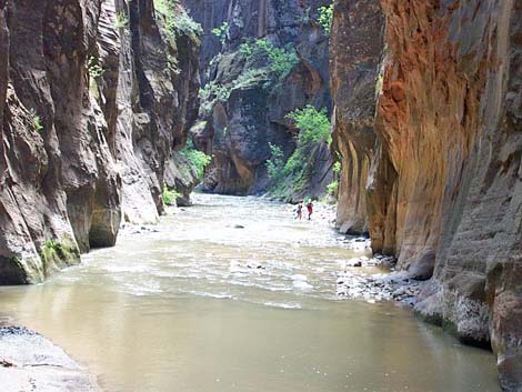
 Virgin River Valley (view W from near trailhead) |
Overview This great route runs along the Virgin River for nearly 16 miles, starting in the high-country northeast of Zion Canyon, running down through spectacular narrow canyons, and ending in Zion Canyon proper. Use-trails along some parts of the route permit quick hiking, but most of the route is slow hiking in the water, and it takes 10-12 hours of hiking at a good pace to complete the route. You will walk in the water, and the sooner you stop making a distinction between water and places to walk, the sooner you will find the walking easy and the route enjoyable. Link to map. |
 First narrows (view W) |
The nature of the canyon changes abruptly at Deep Creek, which is about halfway out. Above Deep Creek, the canyon is petite: the canyon is relatively shallow and tight, and the river is small. In comparison, below Deep Creek the canyon is grand: it is deep and wide, the river is larger, and the cliffs tower above you. Above Deep Creek, you will marvel at the beauty of small things; below there, you will marvel at the grandeur of huge things. In some ways, the upper part of the canyon is nicer, and a hike down to Deep Creek and back would be a wonderful trip, but the lower canyon is just too grand to miss. |
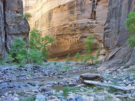
 Typical narrow canyon and small stream above the waterfall (view W) |
Water levels, water temperatures, the weather report, and day length make a big difference on this route. This route probably is best hiked during late summer when air temperatures are high (near 100 degrees), water levels are low (generally less than knee high), and the water is relatively warm. This will make the walking easier and the deep, cold pools more pleasant. However, this is also thunderstorm season, which can bring flash floods, so watch the weather report. The ranger won't issue permits if thunderstorms threaten. This is a long route, but it can be done in a single day during summer when the days are long. Unless you plan to camp in the canyon, there probably isn't enough light in the day to do the route in early spring or late fall, and it would be too cold in winter. The logistics of this hike are somewhat difficult. Permits are required to hike through the narrows, and the availability of permits depends, in part, on the weather forecast for the day of the hike. The rangers give out permits late in the afternoon on the day before the hike, so you have to arrive in the afternoon on the day before the hike. Check the park website for details. Also, this is a one-way route, so you need to arrange a vehicle shuttle of some sort. The concessionaire runs a shuttle service for about $20 per person; contact them for details. Watch Out Other than the standard warnings about hiking in the desert, ...this is a long route with no real way to turn back after you get dropped off and your ride leaves. Be sure that you are up to the route before getting started. |
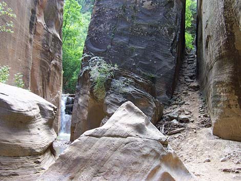 Below the waterfall via slot on the right (view E) |
Water levels and water temperatures make a big difference on this route. This route probably is best during late summer when air temperatures are high (near 100 degrees), and the water level is low (generally less than knee high). Late summer also makes for long days; the Park Service estimates the hiking time at about 12 hours. Late summer is thunderstorm season, and thunderstorms can bring flash floods. Be aware of the weather and plan alternate hikes in the area in case the weather forecast is bad when you arrive. Seek refuge on the highest ground possible if you think that flash floods are possible. Permits are required to hike through the narrows, and the availability of permits depends, in part, on the weather forecast. |
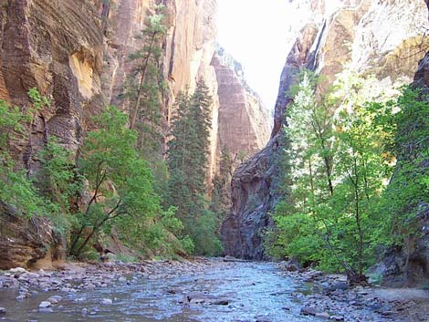
 Typical narrow canyon below waterfall (view W) |
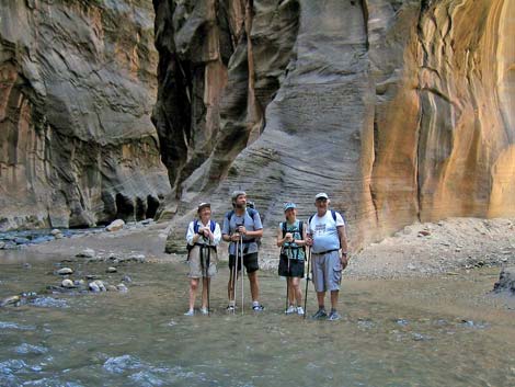
Walking sticks (preferably two trekking poles) are almost a necessity on this route. Most of the route is in the water, which generally is too murky to see the bottom. Walking sticks won't entirely prevent falls, but they will give you a fighting chance of staying on your feet. Some of the rocks, even dry rocks, seemed unusually slippery. My trekking poles are no worse for wear after hiking in the murky water all day, but I got a lot of sand in my shoes. I wore running shoes and was happy with my choice. Plan to get wet, and pack your camera, sleeping bag, and other sensitive gear in waterproof bags. While hiking, please respect the land and the other people out there, and try to Leave No Trace of your passage. Also, this is a long hike in a remote area where rescue would be difficult, so be sure to bring the 10 Essentials. Getting to the Trailhead This hike is located in Zion National Park, about 3 hours northwest of Las Vegas. From town, drive out to Zion National Park. From the Visitor Center (Table 1, Site 863), drive (or hire the shuttle van) north on Highway 9 to the east park entrance (about 25 minutes). Continue east, outside the park, for about more 3 miles to North Fork Road (Site 866), just east of mile marker 4. Turn left onto North Fork Road, which is paved and posted at 35 mph, and drive north. The pavement ends about 5 miles out, but the road continues as a good, graded dirt road (at least when dry). Several side roads intersect North Fork Road, but always continue "straight" past the side road (one side road looked big enough to be a major road, but it clearly is a right turn). |
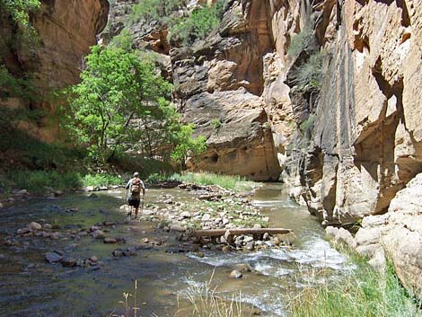
 Hikers in narrow canyon below waterfall (view W) |
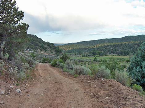
At about 16 miles out North Fork Road, the road crosses a bridge over the North Fork of the Virgin River (Site 867). Cross the river, turn left at the T-intersection, and drive west on the narrow dirt road along the river for about a mile. A 2WD sedan can make it to the trailhead, but a high-clearance vehicle might be better for the last few tenths of a mile. The road narrows abruptly where you might want to stop in a low-slung vehicle. The trailhead (Site 868) is a wide parking area with signs just before the road crosses back over the river (no bridge). The road continues on, but the landowner wants people to stop here (this is private land, not Zion National Park). Stop here; this is the trailhead. The Hike The description of this route is unusually simple: from the trailhead, walk downstream for 10-12 hours until you hit civilization. There are, however, many details. The trail starts in a broad valley between low hills with a small creek (the North Fork of the Virgin River) running west. The vegetation is pinyon-juniper woodland with oaks and a few other trees, plus sagebrush, grass, and lots of cows in the bottom of the valley. From the trailhead (Table 2, Waypoint 1), the route begins by continuing down the road, which crosses the river (actually a creek at this point) and runs up across the valley to the trees on the other side. At this crossing, it probably is worth keeping your feet dry. Across the valley, the road turns right and runs westward along the south side of the valley. About 25 minutes out, the canyon begins to narrow (Wpt. 2), but there still are open areas with sagebrush and grass, and you start getting into a mixed forest with tall ponderosa pines. Shortly thereafter, the road passes an old tractor (Wpt. 3) partially buried under a tree on the left, and then the canyon narrows to finally give the feeling of being in a canyon rather than a valley. However, the road turns a corner, passes a narrow section, and the valley opens up again. |
 Typical narrow canyon above Deep Creek (view W) |
About 50 minutes out, the road passes Bullock's cabin (Wpt. 4), an old log cabin with a collapsing roof. The structure is interesting, but not safe to enter. This would have been a wild place to live back in the old days. About 10 minutes past the cabin (1 hour out), the road ends (Wpt. 5). The trail continues past the end of the road, cutting up a narrow track and running along edge of some cliffs above the creek. This narrow bit of trail is the only place along the route where you could fall and seriously hurt yourself (without trying). It takes only 1-2 minutes to pass this cliffy section, and then the trail drops into the bottom of the drainage and starts winding back and forth across the creek. I annoyed myself at the second creek crossing where I slipped on a rock and got my shoes wet, and I wondered if it was a bad omen, but it was only two or three more minutes down the canyon before I was forced to walk in the creek, so it didn't matter in the end. About 10 minutes past the end of the road, the canyon narrows and starts feeling like Zion Canyon (Wpt. 6) with vertical sandstone cliffs, sagebrush, ponderosa pine, and juniper. In this section, the trail mostly follows benches, dropping into the creek bed and crossing the creek from time to time, but generally you can stay dry to here. The canyon continues to narrow, deepen, darken, and starts to wind back and forth. About 30 minutes beyond the road, the canyon narrows, the trail pinches out, and it is easier to just walk in the water. Through here, you also start getting into other kinds of trees, such as willows, cottonwoods, and maple trees. After running through a narrow winding part, the canyon widens, the walls lay back, and the canyon is straight and open enough for sun to reach the bottom of the canyon (Wpt. 7). |
 Deep Creek (view N from the confluence) |
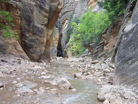
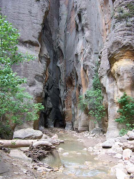
About 2.5 hours out, the canyon narrows again at Simon Gulch (Wpt. 8), the first really narrow narrows. These narrows are short, but quite nice. After the narrows, the canyon opens up a bit and you get to the NPS boundary (Wpt. 9). A few minutes inside the Park boundary, there is another nice narrow section, which is just above Campsite 1. This campsite is located on a low bench along a quiet, picturesque piece of stream and would be a very nice place to spend the night. |
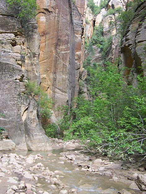
 Typical wide canyon and larger stream below Deep Creek (view S) |
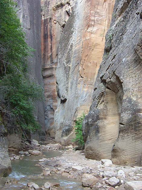
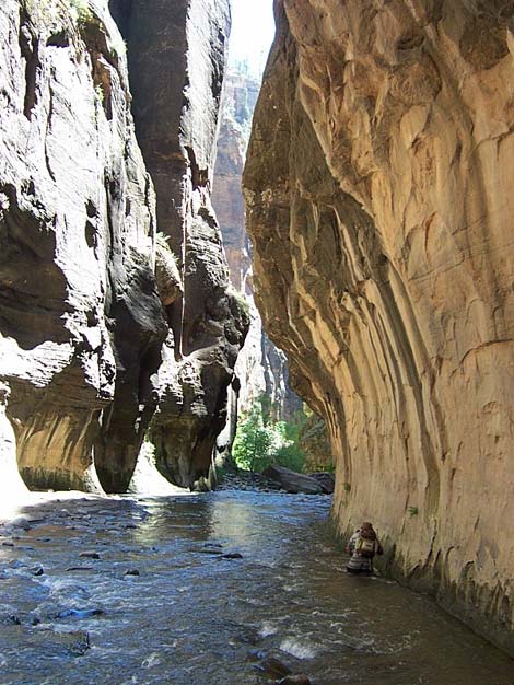
Just past Campsite 1, the river flows over a waterfall (Wpt. 10). This is a wild spot at an abrupt narrowing in the canyon. It appears that a piece of the canyon wall broke off and fell into the creek. Logs then washed down and jammed against the top of the narrow spot, which created a dam that filled in with sand and gravel. The sand is even with the top of the logs, and you can walk right up to the edge of the waterfall. On the south [left] side of the canyon, there is a slot between the canyon wall and the part that broke off where you climb down and around the falls. |
 Below Kolob Creek (view S) |
For the next mile or so, the canyon generally is tight, but it repeatedly narrows and widens slightly as you hike along until you emerge from a narrows into a wider canyon at the confluence of Deep Creek (Wpt. 11). Deep creek adds about twice the volume of the north fork (1/3 plus 2/3s) to the river, so there is quite a bit of water now. Campsite 2 is located at the confluence. I stopped at the confluence to rest for 20 minutes. Below the confluence, the canyon is wide and deep with towering walls and grand vistas down the river, which is very different from the canyon above here. The wider canyon also provides more opportunities for safe campsites, and Campsites 3, 4 (on a bench above the river), and 5 (little spot on a little bench) are all located 10 to 20 minutes below the Deep Creek confluence. |
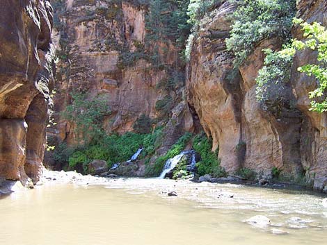 Big Spring (view S) |
About 20 minutes below Deep Creek, the river enters the first set of narrow in the main canyon [1031 hrs], which is just above the mouth of Kolob Creek (Wpt. 12). Campsite 6 is located here high on a bench that would be a safe even in the worst flash flood. Kolob Creek adds another 20% to the water volume, and it is a river now. A bit below Kolob Creek, I fell in river [about 1100 hrs, 5 hours out] and among other things, got my voice recorder wet (which I use to take notes while hiking). The recorder died, and I couldn't record any notes until late in the evening when the unit dried out and came back to life. Fortunately, it has non-volatile RAM, so the morning notes were preserved. |
 Hikers below Big Spring (view S) |
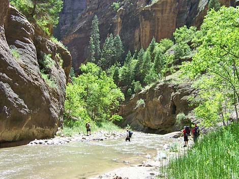
Below Kolob Creek, the canyon is wide, and the banks are forested with a variety of deciduous trees. In many places, there are use-trails along river, so the hiking in much of this part is on dry land. At 10.1 miles out, the route passes Goose Creek (Wpt. 13), which comes down a pretty little side canyon. If you walk up the side canyon a few minutes, you can get good, clear drinking water (or at least clear water to filter). Less than a mile below Goose Creek (10.8 miles out), the route passes Big Spring (Wpt. 14), a well-named gusher that bursts out of the canyon wall a few feet above the river. The water runs over boulders and cascades into the river. This is another place to get good, clear water. |
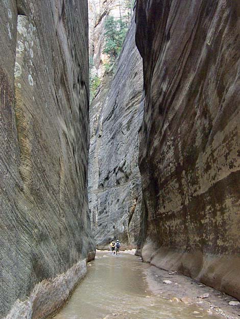
 Typical narrows (view S) |
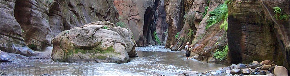
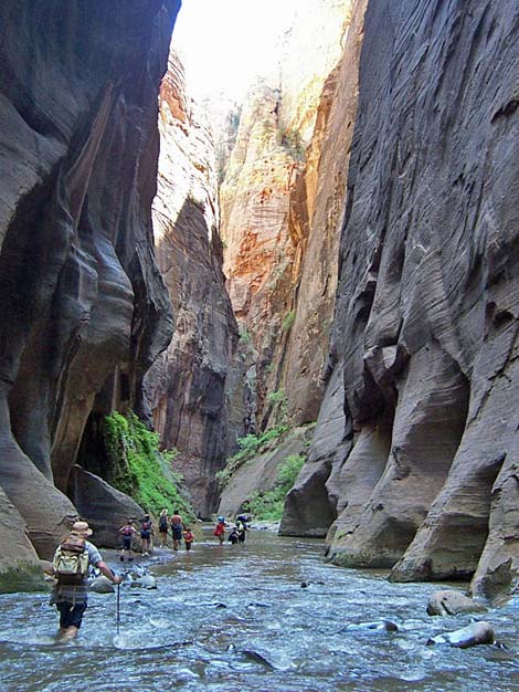
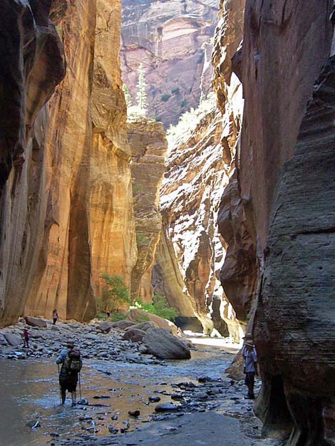
Big Spring marks the start of the "Zion Narrows," which run for the next 2 miles or so. From Big Spring to the mouth of Orderville Canyon (Wpt. 15), the river runs through a fairly narrow gorge with red sandstone cliffs towering above the river. From Orderville Canyon to the end of Riverside Trail (Wpt. 16), the river runs through a fairly narrow, very scenic canyon. If you don't have the time or can't get a permit to walk the entire canyon, the hike up to Orderville Canyon is a great introduction. Hiking up to Orderville Canyon does not require a permit, so you can hike this part without making prior arrangements. After hiking for almost 15 miles in the river, the paved Riverside Trail is a welcome change. This is a very pleasant trail, but by the time you hit the Temple of Sinawava parking area (Wpt. 17), you will be ready for a rest. |
 Hiking on the bank and crossing the river (view S) |
 Confluence of Zion (left) and Orderville (right) canyons (view N) |
 Hiking in the river (view S) |
 Colorful wall in the lower narrows (view S) |
 Typical lower canyon (view S not far from Riverside Trail). |
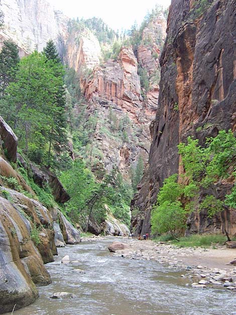 Zion Canyon (view S not far from Riverside Trail) |
Table 1. Highway Coordinates based on GPS data (NAD27; UTM Zone 12S). Note: These are UTM-Zone-12 coordinates.
Download Highway GPS Waypoints (*.gpx) file.
| Site # | Location | Latitude (°N) | Longitude (°W) | UTM Easting | UTM Northing | Elevation (feet) | Verified |
|---|---|---|---|---|---|---|---|
| 0863 | Zion Visitor Center | 37.2000 | 112.9865 | 323702 | 4118706 | 3,940 | Yes |
| 0866 | Highway 9 at North Fork Road | 37.2391 | 112.8331 | 337398 | 4122770 | 6,010 | Yes |
| 0867 | North Fork Road at Virgin River | 37.3904 | 112.8249 | 338450 | 4139545 | 5,970 | Yes |
| 0868 | North Fork Virgin River trailhead | 37.3855 | 112.8379 | 337289 | 4139019 | 5,852 | Yes |
Table 2. Hiking Coordinates based on GPS data (NAD27; UTM Zone 12S). Note: These are UTM-Zone-12 coordinates.
Download Hiking GPS Waypoints (*.gpx) file.
| Wpt. | Location | Easting | Northing | Elevation (ft) | Time | minutes | Cumulative Distance (mi) | Verified |
|---|---|---|---|---|---|---|---|---|
| 01 | Trailhead | 337290 | 4139014 | 5,852 | 0552 | 0 | 0.00 | GPS |
| 02 | Canyon Begins to Narrow | 335476 | 4138004 | 5,704 | 0618 | 25 | . | GPS |
| 03 | Old Tractor | 335296 | 4138087 | 5,693 | 0621 | 3 | . | GPS |
| 04 | Bullock's Cabin | 334778 | 4137455 | 5,653 | 0637 | 16 | 1.5 | GPS |
| 05 | End of Road | 334214 | 4137606 | 5,597 | 0646 | 9 | . | GPS |
| 06 | Feels like Zion Canyon | 333745 | 4137491 | 5,551 | 0653 | 7 | . | GPS |
| 07 | Simon Gulch | 330724 | 4137557 | . | 0830 | 11 | 4.9 | . |
| 08 | Canyon Widens | 330023 | 4137611 | 5,374 | 0819 | 26 | . | GPS |
| 09 | NPS Boundary | 329336 | 4137515 | 5,322 | 0835 | 5 | . | GPS |
| 10 | Campsite 1 Waterfall | . | . | . | 0902 | 27 | 6.9 | . |
| 11 | Deep Creek, depart | 327192 | 4136302 | 5,323 | 1010 | 20 | 8.0 | map |
| 11 | Deep Creek, arrive | 327192 | 4136302 | 5,323 | 0949 | 47 | 8.0 | map |
| 12 | Kolob Creek | 327286 | 4135208 | . | 1040 | 30 | 8.9 | map |
| 13 | Goose Creek | 326695 | 4134003 | . | . | . | 10.1 | map |
| 14 | Big Spring | 326685 | 4133195 | . | . | . | 10.8 | map |
| 15 | Orderville Canyon | 327545 | 4130589 | . | . | . | 12.9 | map |
| 16 | End of Riverside Trail | 327385 | 4129356 | 4,480 | 1540 | . | 14.7 | GPS |
| 17 | Temple of Sinawava Trailhead | 327417 | 4128082 | 4,420 | 1610 | 40 | 15.7 | Yes |
Happy Hiking! All distances, elevations, and other facts are approximate.
![]() ; Last updated 240330
; Last updated 240330
| Hiking Around Zion National Park | Hiking Around Las Vegas | Glossary | Copyright, Conditions, Disclaimer | Home |