Hiking Around Las Vegas, Muddy Mountains Wilderness Area
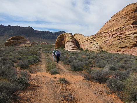
 Hidden Valley Overlook (view SE) |
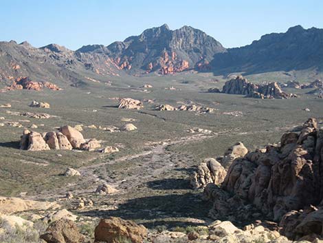
Overview The Arch Trail, which leads to Sandstone Arch, is a delightful hike in the Muddy Mountains Wilderness Area. The 7.4-mile round-trip trail climbs over a steep, rocky ridge to get into Hidden Valley, then mostly follows old roads south to the arch. Hikers can make a partial loop (lollipop loop; 8.3 miles RT) by returning via Colorock Canyon and using dirt roads to return to the Arch Trailhead. Inside Hidden Valley, the area is broad and relatively flat, which makes for easy hiking on old roads. Off the roads, the soil has a high percentage of sand, which makes off-trail walking a bit harder, plus there is a lot of biological soil crust which we should avoid trampling. Red and white sandstone crags dot the valley, and the entire area is overseen by dark limestone cliffs of the Muddy Mountains. Native peoples used the area, so keep an eye out for their handiwork. Link to map or elevation profile. |
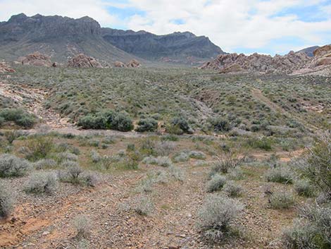
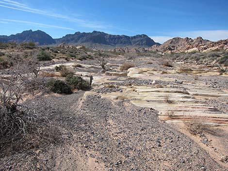 Main wash that drains all of Hidden Valley (view S) |
Watch Out Other than the standard warnings about hiking in the desert, ... this is a safe hike with no unusual hazards. There are places where someone could fall and hurt themselves, so be extra careful along edges. While hiking, please respect the land and the other people out there, and try to Leave No Trace of your passage. This route goes into designated Wilderness, so pay particular attention to respecting the land. This area is little used and nobody will find you out there if you need help, so be sure to bring the 10 Essentials. Cell phones don't work in this area. |
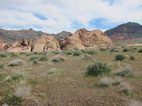
 Old road used as a trail |
Getting to the Trailhead This hike is located on the north side of the Muddy Mountains Wilderness Area, about 1.5 hours north of Las Vegas near Valley of Fire State Park. From Las Vegas, drive north on Interstate 15 for 33 miles to Exit 75E. Turn right onto Highway 169 and drive east for 3.2 miles to Bitter Springs Trail Back Country Byway. Follow the Byway 4.1 miles to Colorock Road, then follow Colorock Road to the Arch Trail Trailhead. |
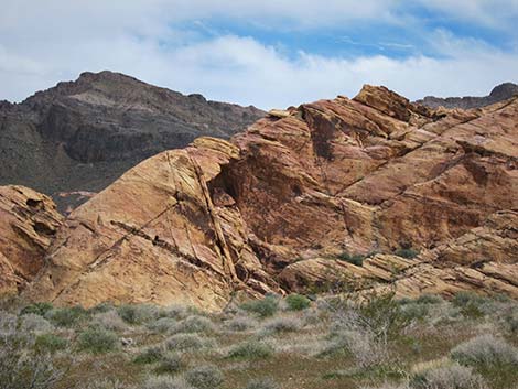
 Approaching the shelter site (view S) |
The Hike From the Arch Trail Trailhead (Table 1, Waypoint 01), the trail runs southeast past a wilderness area sign (Wpt. 02) and towards the high sandstone ridge in the distance. Parts of this trail runs on bedrock, and these parts are marked with large cairns. The trail runs up over a low ridge (Wpt. 03), then climbs steeply to the Hidden Valley Overlook (Wpt. 04) with grand views out over Hidden Valley. For details of this part of the trail, see the Hidden Valley Overlook Route. From Hidden Valley Overlook (Wpt. 04), the trail continues over the ridge following an old ranch trail. Parts of the trail are washed out and hard to follow, and parts run on sandstone slickrock where it is also hard to follow, but watch for cairns and intermittent bits of dirt trail. |
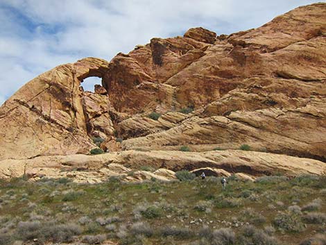
 Arch Rock in the distance (view SW) |
Below the sandstone, the old ranch trail quickly joins an old road at the top of an old turn-around (Wpt. 05), then follows the old road down into the bottom of the valley where it hits the broad, sandy wash that drains all of Hidden Valley (Wpt. 11). At this point, the Arch Trail joins the Colorock Canyon Loop Route, which hikers could use to return to the trailhead. Here, in the north end of Hidden Valley, the Arch Trail runs south following the broad, sandy wash. There is an old road that parallels the wash on the right (west of the wash), but it is pretty faint. While hiking south in the wash, watch for the old road to cross the wash and head southeast (Wpt. 12). The old road crosses the wash here, but it is easier to see on the east side. On the way back, consider following the old road for some different scenery. |
 Approaching Arch Rock (view SE) |
Beyond the wash, the old road is obvious and runs nearly straight southeast to an intersection (Wpt. 13). Here, the road to the east climbs out of Hidden Valley, crosses over the ridge, and runs down to the Hidden Valley East Trailhead, a spur road off the Bitter Springs Trail Back Country Byway. Staying right and continuing southwest, the old road crosses a deep wash. Just before the wash (Wpt. 14), a faint two-track road forks to the left and runs more due south. This is the route to Muddy Peak. A short distance past the wash, the old road passes a side road (Wpt. 15) that runs northwest, then bends southwest and runs out to the west edge of Hidden Valley (Wpt. 24). |
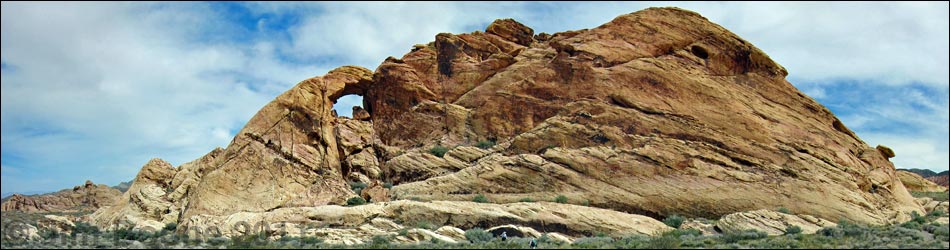
 Arch Rock (view E) |
Continuing southwest, the old road passes a faint two-track road to the east (Wpt. 16). This faint road connects with the road to Muddy Peak. Just beyond the faint road, the main old road passes a sandstone crag, the southeast corner of which was a Native American shelter site. Bits of charcoal, stone flakes, and pot shards can be found, but surprisingly, no artwork. This would have been a nice place to stay when the mornings were cool, but the afternoons were hot. The old road wraps around the south edge of the sandstone crag and runs to the west, then turns southwest and crosses another deep wash. |
 The Arch (view NE) |
Beyond that wash, the old road runs along the east side of another sandstone crag, then continues to the southwest. Hiking through this area, another sandstone crag can be seen to the south (a bit left of the old road). This is the crag that holds the arch. The trail follows the old road until it is convenient to leave the road (Wpt. 17) and runs towards the west side of the crag. The arch is on the northwest corner of the crag, but it is more visible from farther around the west side (Wpt. 18). There is no obvious way to climb into the arch, so enjoy the scene, revel in the grandeur of Wilderness, and wander back to the trailhead. |
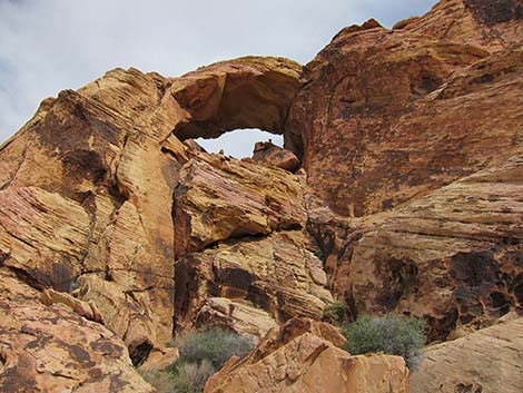 The Arch (view NE) |
Before heading back, consider visiting an interesting tinaja (Site 21) atop a sandstone crag across the valley to the east of the arch. The cross-country route climbs past interesting sandstone outcrops, traverses rolling country, crosses the old two-track to Muddy Peak, and arrives at the sandstone crag. The south end of the crag is an easy walk up. There are three major tinajas atop the crag, and it is hard to imagine how so much water collects with such a small run-off area. On the way out, consider making a loop using the route not used on the way in. For example, hike down Colorock Canyon to Colorock Cabin, and then follow dirt roads back to the Arch Trail Trailhead. |
Table 1. Hiking Coordinates for the Ridge Route (NAD27; UTM Zone 11S). Download Hiking GPS Waypoints (*.gpx) file.
| Wpt. | Location | UTM Easting | UTM Northing | Elevation (ft) | Point-to-Point Distance (mi) | Cumulative Distance (mi) | Verified |
|---|---|---|---|---|---|---|---|
| 01 | Ridge Trailhead | 705412 | 4026301 | 2,905 | 0.00 | 0.00 | GPS |
| 02 | Wilderness Boundary | 705407 | 4026285 | 2,913 | 0.02 | 0.02 | GPS |
| 03 | Sandstone Ridge | 705588 | 4026159 | 3,021 | 0.17 | 0.19 | GPS |
| 04 | Hidden Valley Overlook | 705866 | 4025895 | 3,247 | 0.32 | 0.51 | GPS |
| 05 | End of Old Road | 705937 | 4025640 | 3,057 | 0.19 | 0.70 | GPS |
| 11 | HV Wash at Overlook Route | 706020 | 4025367 | 2,987 | 0.22 | 0.92 | GPS |
| 12 | Wash at Old Road | 705920 | 4024699 | 3,019 | 0.45 | 1.37 | GPS |
| 13 | East Access Route | 706712 | 4023769 | 3,150 | 0.78 | 2.15 | GPS |
| 14 | Muddy Peak Route | 706600 | 4023501 | 3,173 | 0.20 | 2.35 | GPS |
| 15 | Old Side Road West | 706395 | 4023220 | 3,233 | 0.22 | 2.57 | GPS |
| 16 | Old Side Road East | 706268 | 4022952 | 3,265 | 0.19 | 2.76 | GPS |
| 17 | Leave Old Road | 705601 | 4022144 | 3,349 | 0.76 | 3.52 | GPS |
| 18 | Base of Rock Below Arch | 705762 | 4022048 | 3,345 | 0.18 | 3.70 | GPS |
Happy Hiking! All distances, elevations, and other facts are approximate.
![]() ; Last updated 240330
; Last updated 240330
| Hiking Wilderness Areas | Hiking Around Las Vegas | Glossary | Copyright, Conditions, Disclaimer | Home |