Hiking Around Las Vegas, Red Rock Canyon NCA
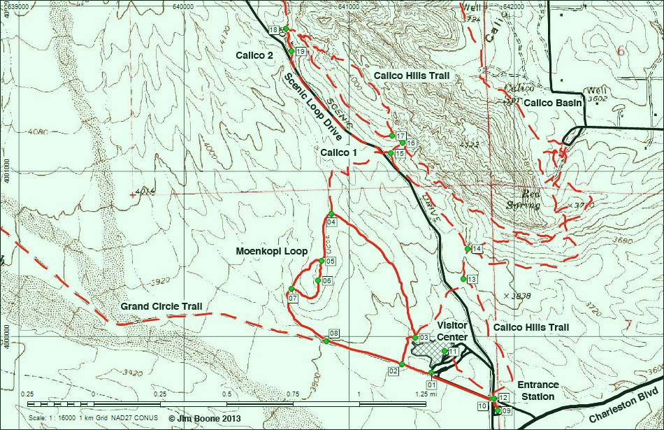
Note: Roads are black (solid = paved; dashed = unpaved). Trails and routes are red (solid = main; dashed = adjacent or alternate). Map based on USGS 7.5-minute topo map. North is at the top. UTM Grid is NAD27 CONUS.
Table 1. Hiking Coordinates and Distances based on GPS Record (NAD27; UTM Zone 11S). Download Hiking GPS Waypoints (*.gpx) file.
| 09 | Entrance Station Trailhead | 641901 | 3999549 | 3,690 | 0.00 | 0.00 | GPS |
| 01 | Moenkopi-Grand Circle Trailhead | 641499 | 3999777 | 3,717 | 0.31 | 0.31 | GPS |
| 02 | Trail Junction | 641321 | 3999828 | 3,743 | 0.12 | 0.43 | GPS |
| 03 | Trail Junction | 641403 | 3999990 | 3,732 | 0.14 | 0.57 | GPS |
| 04 | Trail Junction | 640896 | 4000740 | 3,910 | 0.61 | 1.18 | GPS |
| 05 | Trail Junction | 640834 | 4000454 | 3,942 | 0.20 | 1.38 | GPS |
| 06 | Moenkopi Summit | 640815 | 4000336 | 3,956 | 0.08 | 1.46 | GPS |
| 07 | Trail Junction | 640653 | 4000285 | 3,858 | 0.16 | 1.62 | GPS |
| 08 | Trail Junction | 640865 | 3999968 | 3,780 | 0.28 | 1.90 | GPS |
| 02 | Trail Junction | 641321 | 3999828 | 3,743 | 0.30 | 2.20 | GPS |
| 01 | Moenkopi-Grand Circle Trailhead | 641499 | 3999777 | 3,717 | 0.12 | 2.32 | GPS |
| 09 | Entrance Station Trailhead | 641901 | 3999549 | 3,690 | 0.30 | 2.62 | GPS |
Happy Hiking! All distances, elevations, and other facts are approximate.
![]() ; Last updated 130407
; Last updated 130407
| Visitor Center Area Loops | Hiking Around Red Rock Canyon | Glossary | Copyright, Conditions, Disclaimer | Home |