Hiking Around Las Vegas, Red Rock Canyon NCA
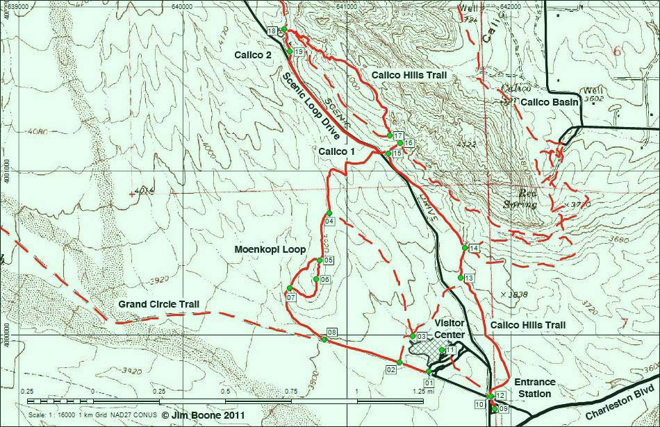
Note: Roads are black (solid = paved; dashed = unpaved). Trails and routes are red (solid = main; dashed = adjacent or alternate). Map based on USGS 7.5-minute topo map. North is at the top. UTM Grid is NAD27 CONUS.
Table 1. Hiking Coordinates and Distances based on GPS Record (NAD27; UTM Zone 11S). Download Hiking GPS Waypoints (*.gpx) file.
| Wpt. | Location | Easting | Northing | Elevation (ft) | Point-to-Point Distance (mi) | Cumulative Distance (mi) | Verified |
| 09 | Entrance Station Trailhead | 641901 | 3999549 | 3,690 | 0.00 | 0.00 | GPS |
| 12 | Calico Hills Trail at road | 641879 | 3999621 | 3,691 | 0.05 | 0.05 | GPS |
| 13 | Trail Junction | 641692 | 4000346 | 3,790 | 0.55 | 0.60 | GPS |
| 14 | Trail Junction | 641721 | 4000529 | 3,809 | 0.12 | 0.72 | GPS |
| 15 | Calico I | 641256 | 4001107 | 3,952 | 0.48 | 1.20 | GPS |
| 16 | Trail Junction | 641326 | 4001170 | 3,905 | 0.06 | 1.26 | GPS |
| 17 | Trail Junction | 641261 | 4001214 | 3,866 | 0.06 | 1.32 | GPS |
| 18 | Trail Junction | 640618 | 4001863 | 3,993 | 0.74 | 2.06 | GPS |
| 19 | Calico II | 640655 | 4001725 | 4,063 | 0.09 | 2.15 | GPS |
| 15 | Calico I | 641256 | 4001107 | 3,952 | 0.54 | 2.69 | GPS |
| 04 | Trail Junction | 640896 | 4000740 | 3,910 | 0.47 | 3.16 | GPS |
From the Moenkopi trail junction, the two routes diverge.
The shorter, more direct route back to the Visitor Center:
| Wpt. | Location | Easting | Northing | Elevation (ft) | Point-to-Point Distance (mi) | Cumulative Distance (mi) | Verified |
| 04 | Trail Junction | 640896 | 4000740 | 3,910 | 3.16 | 3.16 | GPS |
| 03 | Trail Junction | 641403 | 3999990 | 3,732 | 0.61 | 3.77 | GPS |
| 02 | Trail Junction | 641321 | 3999828 | 3,743 | 0.14 | 3.91 | GPS |
| 01 | Moenkopi-Grand Circle Trailhead | 641499 | 3999777 | 3,717 | 0.12 | 4.03 | GPS |
| 09 | Entrance Station Trailhead | 641901 | 3999549 | 3,690 | 0.30 | 4.33 | GPS |
The longer route over the top of Moenkopi Hill and back to the Visitor Center
| Wpt. | Location | Easting | Northing | Elevation (ft) | Point-to-Point Distance (mi) | Cumulative Distance (mi) | Verified |
| 04 | Trail Junction | 640896 | 4000740 | 3,910 | 3.16 | 3.16 | GPS |
| 05 | Trail Junction | 640834 | 4000454 | 3,942 | 0.20 | 3.36 | GPS |
| 06 | Moenkopi Summit | 640815 | 4000336 | 3,956 | 0.08 | 3.44 | GPS |
| 07 | Trail Junction | 640653 | 4000285 | 3,858 | 0.16 | 3.60 | GPS |
| 08 | Trail Junction | 640865 | 3999968 | 3,780 | 0.28 | 3.88 | GPS |
| 02 | Trail Junction | 641321 | 3999828 | 3,743 | 0.30 | 4.18 | GPS |
| 01 | Moenkopi-Grand Circle Trailhead | 641499 | 3999777 | 3,717 | 0.12 | 4.30 | GPS |
| 09 | Entrance Station Trailhead | 641901 | 3999549 | 3,690 | 0.30 | 4.60 | GPS |
Happy Hiking! All distances, elevations, and other facts are approximate.
![]() ; Last updated 110130
; Last updated 110130
| Visitor Center Area Loops | Hiking Around Red Rock Canyon | Glossary | Copyright, Conditions, Disclaimer | Home |