Hiking Around Las Vegas, Mojave National Preserve
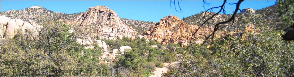
 Photo 1. Joshua Tree Forest |
Text and Photos by Mark Petterson, Henderson Overview Caruthers Canyon is a botanical and geologic gem hidden at about 6,000 feet in the New York Mountains of Mojave National Preserve. A beautiful canyon of towering castellated mountains is filled with fascinating rock formations, and the diversity of plant life is unusual for the desert. For those readers who have been to these places, it's as if Mother Nature had taken the granite rock formations of Joshua Tree National Park and set them down in the middle of the Newberry Mountains (Christmas Tree Pass area), then sprinkled in some coastal California flora. Caruthers Canyon is definitely a worthwhile trip; it is relatively easy to get to, and most of the hike is not difficult. Link to map or link to description of the hike to Giant Ledge Mine. |
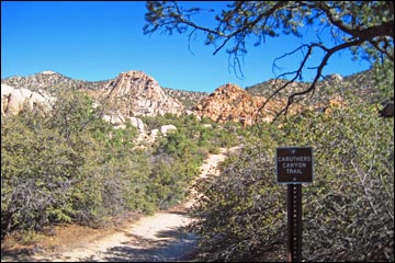 Photo 2. Caruthers Canyon Trail Sign |
Watch Out Other than the standard warnings about hiking in the desert, ... this is a fairly easy drive and hike. Although 2WD vehicles with a decent ground clearance should be able to handle most of the drive during good weather, a 4WD vehicle would be safer, especially near the canyon. Also, this is wild and remote country, so make sure you have plenty of fuel and water, and notify someone of your travel plans. Your cell phone probably won't work. |
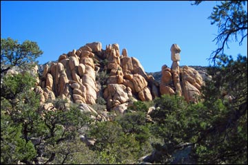 Photo 3. Balancing Rock on Spire |
The last two legs of the drive, New York Mountains Road and Caruthers Canyon Road, are mostly loose, sandy soil where it is possible to get stuck. Also, about 1/2-miles before the trailhead, the road crosses a wash with a relatively deep drop-off that probably is impassable in a 2WD vehicle. If you do any rock scrambling on the spectacular rock formations, be careful. For Las Vegans accustomed to climbing on sandstone, these granite rocks offer few good handholds and footholds, unlike the plentiful sandstone ledges closer to home. The rock surface is also rough and coarse, and bare legs will get scraped up easily. Lastly, there is an old gold mine at the end of the trail. Be safe and do not enter the dark, dangerous mine shafts. |
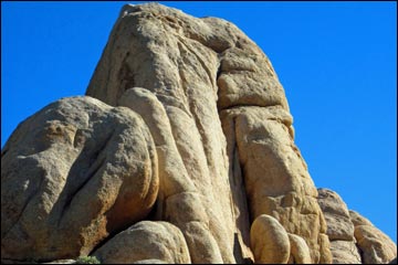 Photo 4. Climbing Challenge |
While out, please respect the land and the other people out there, and try to Leave No Trace of your passage. There are primitive campsites near the trailhead, so please respect the privacy of campers. Due to the remote location of this canyon, be sure to bring the 10 Essentials. Although Mojave National Preserve has good signs for most roads, bring a good backcountry map and a GPS. Remember that driving off roads, in washes, or cross country damages the fragile desert soil and is prohibited by National Park Service regulations. Please check with the local rangers (760-252-6100) on the road conditions before driving into the backcountry. Maps of the Mojave backroads are available online and at the various Visitor Centers at Kelso, Hole In The Wall, and Baker. |
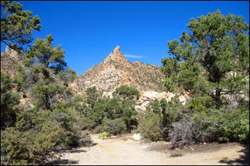 Photo 5. Elf's Cap |
Getting to the Trailhead This hike is located in the Mojave National Preserve, about 2 hours south of Las Vegas. From town, take I-15 south and exit at Nipton Road (Table 1, Site 1008). Turn left and drive east about 4 miles to Ivanpah Road (Site 1264). Turn right and drive south on Ivanpah Road for about 24 miles. The road crosses the Union Pacific Railroad tracks at the old town of Ivanpah, turns to a graded dirt road (Site 1266), passes over the foothills of the New York Mountains, and runs through a lovely Joshua tree forest where many large old specimens can be found (Photo 1). At the old OX Cattle Ranch (buildings and windmill) (Site 1259), turn right on the signed New York Mountain Road. Drive west on the sandy road for about 5-1/2 miles to an unsigned four-way intersection (Site 1260). Turn right and drive north, passing an old windmill (Site 1261), for most of two miles to a wash crossing (Site 1262). Hikers with 2WD vehicles are advised to stop here. Otherwise, continue for about 3/4-miles to the trailhead and primitive campsites (Site 1263). |
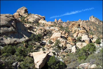 Photo 6. New York Mountain |
Botany and Geology of Caruthers Canyon Areas where the flora is quite different from the surrounding landscape, such as Caruthers Canyon, are sometimes referred to as "disjuncts," "unusual plant assemblages," or "islands on the land." Regardless of the name, the botanically unique area around Caruthers Canyon is an unexpected pleasure. Nearly 300 plant species occur in the area, including pinyon pine, white fir, juniper, oak, and a diversity of coastal chaparral plants including yerba santa, manzanita, coffee berry, and ceanothus. It is quite a surprise to find a coastal ecosystem in the middle of the desert; these are remnants of a widespread coastal scrub community from cooler, wetter times. When the climate turned warmer and drier, these "islands" of old Rocky Mountain and coastal California flora were isolated in higher areas where the climate was more moist and cool. |
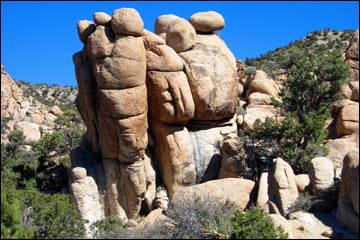 Photo 7. Giant's Foot |
The incredible rock outcroppings in the canyon are remnants of molten magma that oozed upward and cooled deep underground over 100 million years ago. These intrusions, called plutons, formed a granitic rock type called monzogranite. Monzogranite tends to develop joints (cracks) in a rectilinear pattern, which is evident in the rock formations. Over millions of years, the overlying rock eroded away and exposed the plutonic rocks. Further erosion transformed the monzogranite into the spires and the otherworldly rounded shapes seen today. The rounded shapes formed when groundwater percolated into the joints and dissolved some of the hard monzogranite into soft clay. The water dissolved the sharp edges and corners in a manner similar to holding a square ice cube under warm water: the corners melt off first and the "cube" develops rounded corners. |
 Photo 8. Miniature Half Dome |
The Hike The trail follows an old mining road and is fairly easy hiking for most of the way to the old mine. The length of the hike depends on the starting point, but it is about 1.2 miles from the 2WD parking by the wash (Site 1262) to the mine site (Site 1263). This author did not hike all the way to the mine at the end of the trail, so the trail conditions in that portion are not included here. If you start hiking at the "Caruthers Canyon Trail" sign (Photo 2), look to the right (east) almost immediately after hitting the trail and you will be treated to a spectacular rock formation, including a balancing rock on a narrow spire (Photo 3). This jumble of rocks makes for fun rock scrambling; another nearby rock spire (Photo 4) would present a stiffer climbing challenge. Continuing to hike north on the trail, note the diversity of vegetation. |
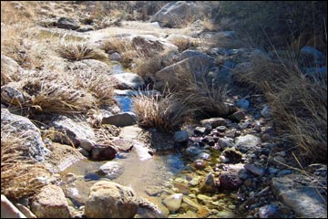 Photo 9. Seasonal Stream |
A scenic mountain looming directly in front of you looks like an elf's cap (Photo 5), but the highest mountain on the ridge to the northwest is the namesake peak of the range, New York Mountain (elevation 7,532 ft) (visible on the right side of Photo 6). It is crowned with a relict stand of Rocky Mountain white fir. Soon you will reach a whimsical rock formation that looks like the bottom of a 3-toed giant's foot (Photo 7). Off to your left is a wonderland of granite rocks and boulders, including one towering formation that looks a bit like a miniature Half Dome, although the flat side isn't as sheer (Photo 8). |
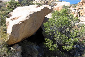 Photo 10. Boulder Cave |
The trail then dips down into a wash with a perennial stream (Photo 9) and two huge fallen rocks that formed a cave (Photo 10). Also in this area is an interesting cluster of rocks perched on top of another granite outcropping (Photo 11). This is as far as this author hiked; I'm sure that additional scenic wonders lie beyond this point. If you go all the way to the mine, be careful and do not enter the old mining structures. Retrace your footsteps back to your vehicle; as always, you will notice more scenic wonders that you somehow missed on your way out, such as other fascinating plutonic formations. |
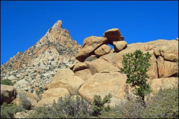 Photo 11. Granite Outcrop |
When driving out, consider turning west on New York Mountains Road to make a loop through the Mojave Preserve, after consulting park personnel about road conditions. Then consult a good backcountry map and follow your GPS to Cedar Canyon Road. This will lead you to the heart of Mojave National Preserve where you can access the plethora of spectacular sights and historic places in this desert wonderland, including the main highway and a return to Las Vegas. |
Table 1. Highway Coordinates (NAD27; UTM Zone 11S). Download Highway GPS Waypoints (*.gpx) file.
| Site | Location | UTM Easting | UTM Northing | Latitude (N) | Longitude (W) | Elevation (ft) | Verified |
|---|---|---|---|---|---|---|---|
| 1008 | I-15 at Nipton Rd | 640822 | 3926437 | 35.47327 | 115.44788 | 3,432 | Yes |
| 1259 | Ivanpah Rd at NY Mts Rd | 663698 | 3896831 | 35.20293 | 115.20177 | 4,280 | GPS |
| 1260 | NY Rd at Caruthers Rd | 655000 | 3898274 | 35.21732 | 115.29701 | 5,397 | GPS |
| 1261 | Caruthers Rd at Windmill | 654742 | 3899151 | 35.22527 | 115.29968 | 5,510 | GPS |
| 1262 | Caruthers Rd at 2WD parking | 654729 | 3900872 | 35.24078 | 115.29950 | 5,623 | GPS |
| 1263 | Caruthers Cyn Mine Site | 654718 | 3902453 | 35.25503 | 115.29932 | 6,069 | GPS |
| 1264 | Nipton Rd at Ivanpah Rd | 646208 | 3924862 | 35.45829 | 115.38882 | 2,747 | GPS |
| 1265 | Ivanpah Rd at Morning Star Mine Rd | 647358 | 3919902 | 35.41342 | 115.37706 | 2,837 | GPS |
| 1266 | Ivanpah Rd at End of Pavement | 656680 | 3910784 | 35.32981 | 115.27617 | 3,927 | GPS |
Happy Hiking! All distances, elevations, and other facts are approximate.
![]() ; Last updated 240328
; Last updated 240328
| Hiking Around Mojave Preserve | Hiking Around Las Vegas | Glossary | Copyright, Conditions, Disclaimer | Home |