Hiking Around Las Vegas, Lake Mead National Recreation Area
 Spooky Canyon (view NE from outside highway fence) |
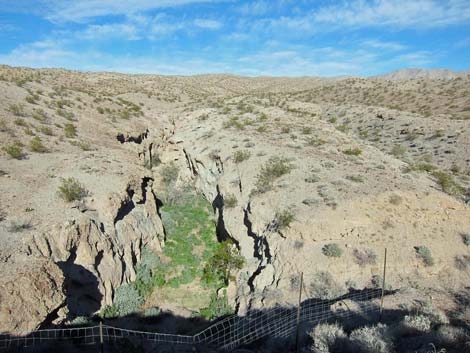
Co-authored by Mark Petterson, Henderson Overview Spooky Canyon is a fascinating slot canyon in Lake Mead National Recreation Area in Arizona, not far south of Hoover Dam. This short route (1-mile round trip) runs up into a scenic and interesting slot canyon where water carved narrow and sinuous passages into conglomerate rock. There are three side canyons, one of which is particularly dark and spooky, and two pour-overs farther up the main canyon for more adventurous hikers. Despite being located next to busy Highway 93, this dark and mysterious canyon is seldom visited, yet it makes a nice addition to a day of hiking to Liberty Bell Arch or Arizona Hot Springs. Construction of the new highway included a wildlife fence along the highway that is tough to climb over, but holes under the fence permit hiker access. Link to map. |
 |
Watch Out Other than the standard warnings about hiking in the desert, ... this hike is safe if hikers don't climb the pour-overs, which are easy Class-5. Other than the pour-overs, the hardest part is scrambling down the loose gravel below the road to get into the canyon. After that, the wash is an easy hike. However, be aware of the weather and stay out if rain is expected; you definitely don’t want to get caught here in a flash flood. Also, there are places where the canyon is as narrow as 2-3 feet wide. If you have claustrophobia, you might stay out of the dark, narrow places where this canyon is, indeed, spooky. Also, watch for low hanging rock walls. While hiking, please respect the land and the other people out there, and try to Leave No Trace of your passage. Also, even though this hike is short, rescues from narrow canyons can be difficult, so be sure to bring what you need of the 10 Essentials. |
 |
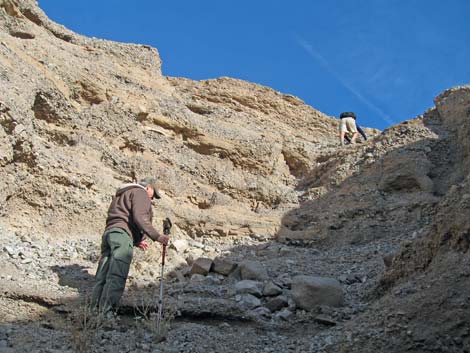
Getting to the Trailhead This hike is located along Highway 93 in Arizona, south of the Hoover Dam in Lake Mead National Recreation Area, about 45 minutes southeast of Las Vegas. From town, drive out to Lake Mead, over the bridge into Arizona, and down to the White Rock Canyon Trailhead. Park here; this is the safe trailhead. Alternatively, at the White Rock cross-over, make a U-turn and drive back to the Original Spooky Canyon Trailhead. It is never safe to pull on or off a high-speed highway. Park here; this is the original trailhead. |
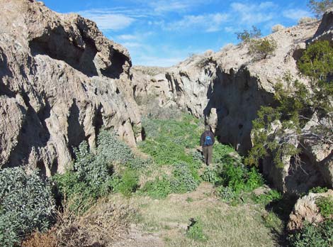
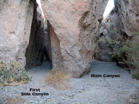
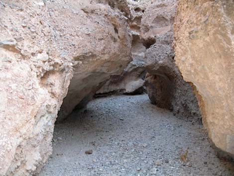
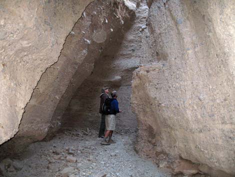
 First fork in the canyon; main goes right (view NE) |
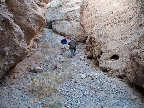
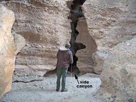
The Hike From the White Rock Trailhead, the route runs northwest along the shoulder of the highway for about 0.4 miles. From the Original Trailhead (Table 1, Waypoint 01), the route runs southeast along the shoulder of the highway (outside the guardrail) to the far side of Spooky Canyon (Wpt. 02) where holes permit hikers to slide under the fence. Construction of the new highway included in a high wildlife fence along the road that is tough to climb over. There are holes under the fence, especially towards the south side of mouth of Spooky Canyon. Photos of the fence are posted here. Past the fence, the route runs up the wash into the canyon. In the first 150 yards or so, there are several large catclaw acacia trees to duck under, but soon the route leaves them behind and reaches the first side canyon (Wpt. 03). The route runs up the main canyon to the right, but the left fork leads into a short, narrow side canyon. |
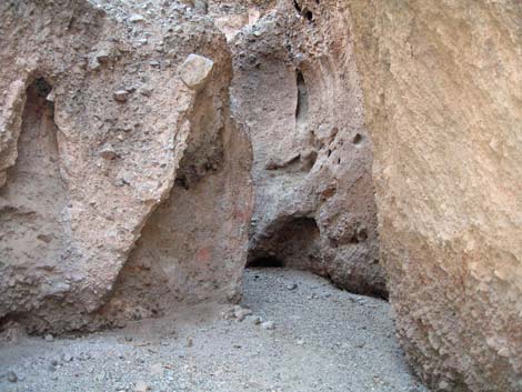
 First side canyon (left) |
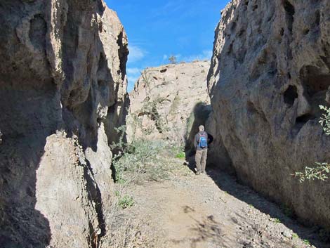
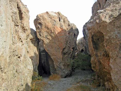
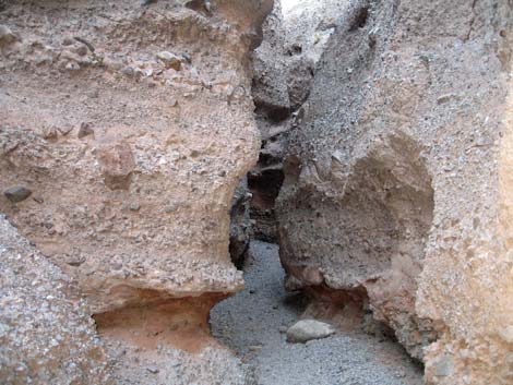
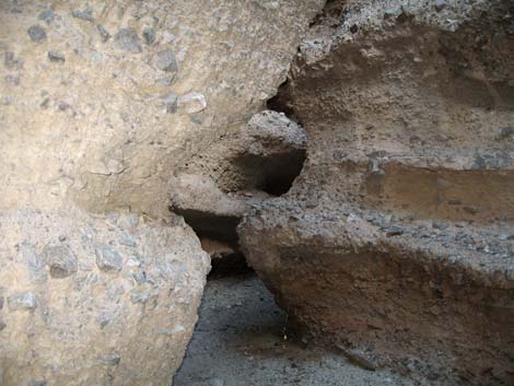
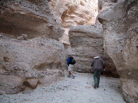
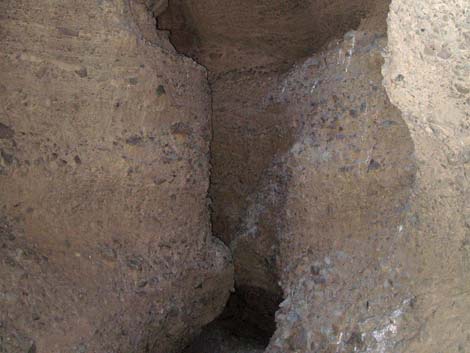
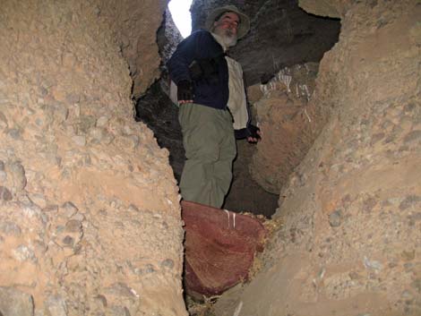
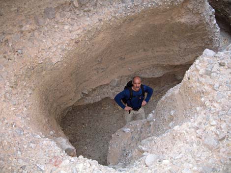
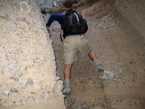
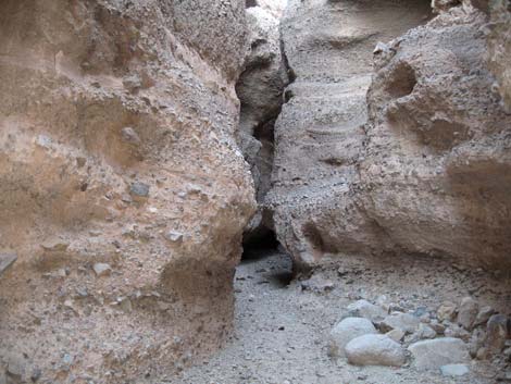
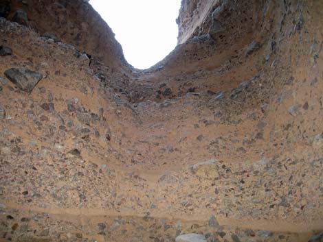
Farther up, the main canyon becomes increasingly narrow, deep, and sinuous (Photo 1442). Rainwater and flash floods over the eons carved this canyon into the conglomerate rock, which was formed from alluvial fan debris as the mountains above eroded away. This type of rock is called fanglomerate because it was formed from an ancient alluvial fan ("alluvial fan" + "conglomerate" = "fanglomerate"), and canyons in fanglomerate rock often show extraordinary sculpting. After winding through narrow passages, the main canyon intersects a second side canyon to the north (Wpt. 04). This side canyon is wide and shallow, and it runs steeply up and out of the main canyon. With a bit of Class-4 scrambling at the top, this side canyon can be used to exit the main canyon. The main canyon continues to the right and soon reaches the third side canyon. This side canyon might be the highlight of the trip – an exquisitely carved narrow canyon that is probably where the name "Spooky Canyon" was derived. You will know that you have arrived here when you see a rock that looks like an alien's head; this rock is the left side of the "portal" that leads into "spooky" canyon. |
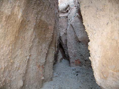 Inside the short first side canyon (view N) |
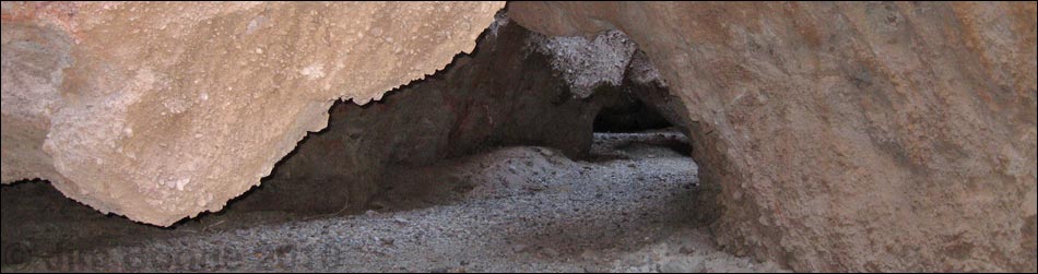
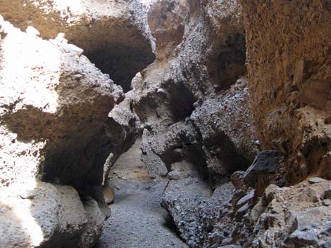
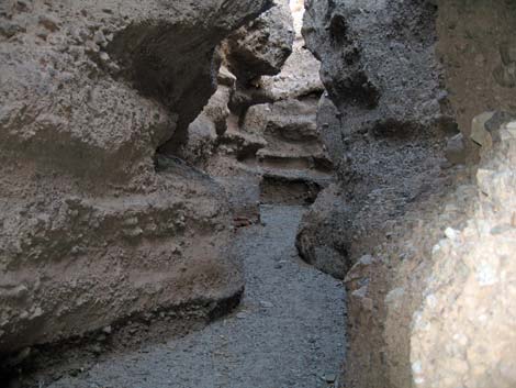
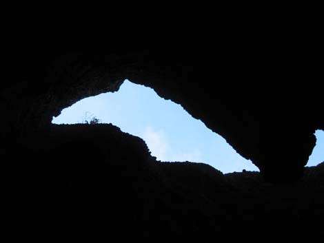
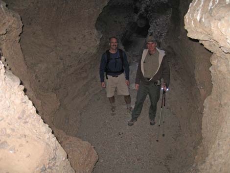
The top of the portal is essentially a natural bridge, and there are other openings just behind it that have turned the roof of this canyon entrance into a spectacular rock sculpture. Unless you are claustrophobic, go deeper into this slot canyon and marvel over the narrow, sinuous walls, which are so narrow all the way to the top that you can only see a slit of sky. This is an extraordinary place, albeit a bit spooky. It is so dark in here that owls find it a good place to roost. The "spooky" side canyon ends at a 20’ cliff, which probably can be climbed without great difficulty to exit the canyon to the sunlight above. Back into the main canyon, the route continues up the wash for another 150 feet or so to a 10- to 12-foot pour-over (Wpt. 06) that is a bit tricky to climb due to the lack of secure handholds and footholds. There are lots of little pebbles and a big rock sticking out of the rock wall, but none feel secure, making this easy Class-5 climbing. Before starting up, stop to consider that it is always easier to climb up than down. |
 Main canyon (view NE) |
Above the first pour-over, the route continues up the canyon, which is similar to the canyon lower down. After only about 200 feet of winding passages, the route reaches the second, higher pour-over (Wpt. 07). This pour-over is about 20-ft high, the holds are smaller and less secure feeling than the lower pour-over, but it is still easy Class-5 climbing. This is the end of the slot canyon, and the climb out leads to an open wash, so there is no real reason to climb this pour-over and risk a fall and a broken ankle this far up a narrow canyon. If you do climb out of the canyon, you can hike north to a ridge, and follow the ridgeline back to the trailhead. Return to the trailhead by following your footprints back down the wash. Back on the road at the mouth of the canyon, consider walking a short distance further southeast along the gravel road to another small slot canyon: "Spooky Jr." This canyon it is similar to Spooky Canyon, but it is more difficult to descend into, shorter, shallower, and less scenic. Nevertheless, it is still interesting to explore. If you like these canyons, don't miss Sidewinder Canyon over in Death Valley National Park. |
 Main canyon |
 Main canyon |
 Main canyon |
 Main canyon |
 Main canyon |
 Second side canyon |
 Climber exiting second side canyon |
 Back in the main canyon |
 Third fork; entrance to "spooky" canyon (view NE) |
 Teaser view inside "spooky" side canyon (view N) |
 Blue sky above "spooky" side canyon (view up) |
 Inside "spooky" side canyon |
 Inside "spooky" side canyon |
 Climber below first pour-over |
 First pour-over (view E) |
 Main canyon between first and second pour-overs |
 Hikers consider climbing the second pour-over. |
 Second pour-over; end of the canyon (view up) |
Table 1. Hiking Coordinates based on GPS data (NAD27; UTM Zone 11S). Download Hiking GPS Waypoints (*.gpx) file.
| Wpt. | Location | UTM Easting | UTM Northing | Elevation (ft) | Point-to-Point Distance (mi) | Cumulative Distance (mi) | Verified |
|---|---|---|---|---|---|---|---|
| 01 | Trailhead | 706773 | 3984407 | 1,565 | 0.00 | 0.00 | GPS |
| 02 | Slide Under Fence | 706959 | 3984346 | 1,557 | 0.13 | 0.13 | GPS |
| 03 | First Side Canyon | 706973 | 3984467 | 1,549 | 0.11 | 0.24 | GPS |
| 04 | Second Side Canyon | 707078 | 3984645 | 1,580 | 0.15 | 0.39 | GPS |
| 05 | Third Side Canyon | 707153 | 3984704 | 1,592 | 0.06 | 0.45 | GPS |
| 06 | First Pour-Over | 707193 | 3984722 | 1,621 | 0.03 | 0.48 | GPS |
| 07 | Second Pour-Over | 707250 | 3984739 | 1,639 | 0.01 | 0.49 | GPS |
| 01 | Trailhead | 706773 | 3984407 | 1,565 | 0.49 | 0.98 | GPS |
Happy Hiking! All distances, elevations, and other facts are approximate.
![]() ; Last updated 240326
; Last updated 240326
| Hiking Around Lake Mead | Hiking Around Las Vegas | Glossary | Copyright, Conditions, Disclaimer | Home |