Hiking Around Las Vegas, Lake Mead National Recreation Area
 Route up hillside from near Lovell Wash (view E) |
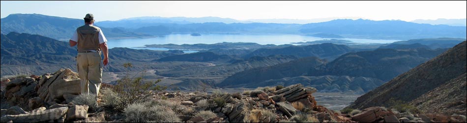
Overview This great hike starts by hiking 2.7 miles up through the Lovell Wash Narrows, perhaps the most scenic narrows in all of southern Nevada. The route then runs for another 2 miles following washes through red and white mud hills. Leaving the wash, the route ascends a ridge to a saddle with grand views out over the Bowl of Fire, perhaps the most scenic red sandstone in southern Nevada. Finally, the route follows a narrow rocky ridge to the summit with grand views out over the desert and Lake Mead. Link to map or elevation profile. |
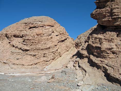 Route leaves main wash through cleft (view E) |
Watch Out Other than the standard warnings about hiking in the desert, ...this is an old mining district. While mines are inherently interesting, they are always dangerous. It is never safe to go into old mines. If you go into a mine, don't touch anything, watch for holes in the floor, and if there is rubble on the floor, assume that it fell from the roof and get out. Be sure to review the standard warnings about holes in the ground. If rain threatens, don't hike in the narrows because a flash flood could ruin your whole day. While not particularly dangerous, there are places on the summit ridge where you could fall a long way. |
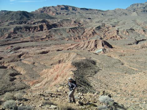
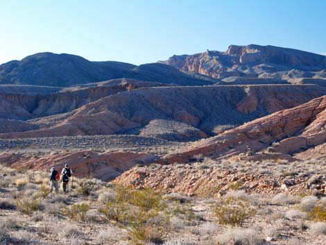 Hikers on gentle slopes beyond ditch (view NW) |
While hiking, please respect the land and the other people out there, and try to Leave No Trace of your passage. Also, this hike is fairly short, so just bring what you need of the 10 Essentials. Getting to the Trailhead This hike is located along Northshore Road in Lake Mead National Recreation Area, about 45 minutes northeast of Las Vegas. From town, drive out to Lake Mead, then drive north on Northshore Road to the Mile 16.0 (Anniversary) Trailhead. |
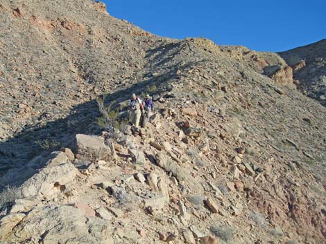
 Hiker climbing ridge below saddle (view NW) |
The Hike From the 2WD trailhead (Table 2, Waypoint 01), either walk or drive up Road 94a, which turns out of Callville Wash and runs northwest towards the hills. From the 4WD parking area (Wpt. 02), follow Road 94a down into Lovell Wash, turn right, and hike upstream all the way through the narrows. For details on this section of the hike, see the Lovell Wash Narrows hike. It is possible that hikers can drive all the way to the mouth of the narrows. Upstream from the narrows (Wpt. 06), the canyon opens into a broad valley that runs northeast for a few miles into the Muddy Mountains. The route follows the wash upstream to a major fork (Wpt. 07), then turns east into the right fork (Wpt. 08), which bends back to the north. Shortly, the route passes a narrow side wash on the right (Wpt. 09). The side wash provides an alternate route, but it is narrow, winding, and slower. Perhaps consider this on the way down. |
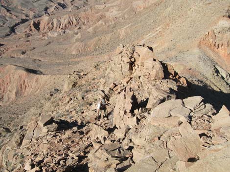
 Hiker climbing towards saddle (view SE) |
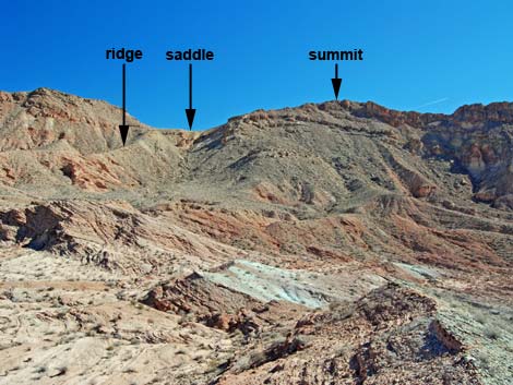
The route runs northward up the main wash. The route passes a smaller side wash on the left (Wpt. 10; stay right) and arrives at a side wash on the right the comes through a cleft in the canyon wall (Wpt. 11). The route turns right and climbs through the cleft heading northeast. Near the top of this cleft, the route turns right again (Wpt. 12), out of the wash, and onto a bench above the wash. The route continues generally east and crosses a 30-ft deep gully (Wpt. 14). This is the wash that flows to the alternate route passed earlier (Wpt. 09). The route continues east and climbs a ridge that runs up to a saddle (Wpt. 16). The views are grand at the saddle, and this is a good place to stop for hikers who don't want to climb the peak. |
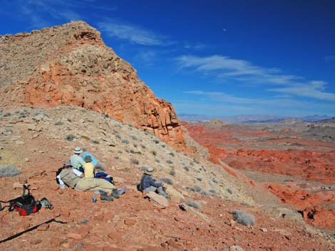 Hikers relaxing on saddle (view NE) |
Continuing, from the saddle (Wpt. 16), the route turns south and runs up the summit ridge to the peak (Wpt. 17). The view from the peak is about as good as it gets in the Lake Mead region. From the summit, consider retracing the route to the saddle and back down to the gully. At the 30-foot-deep canyon, turn downstream and follow that wash back to the main canyon for some interesting variety. Alternatively, hikers can continue south, making a big loop returning to the trailhead by the highway. |
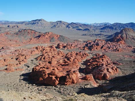 Bowl of Fire from the saddle (view E) |
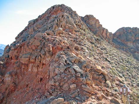
 Hiker coming up summit ridge (view N) |
 Summit Ridge (view S) |
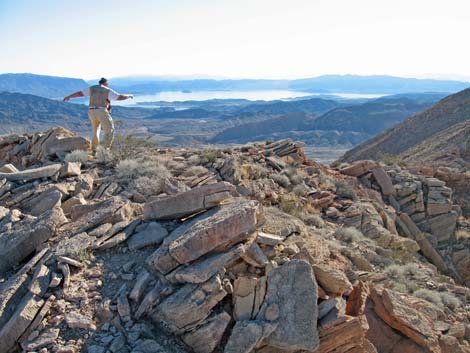 Hiker on summit (view S across Lake Mead) |
Table 2. Hiking Coordinates Based on GPS Data (NAD27, UTM Zone 11S). Download GPS Waypoints (*.gpx) file.
| Wpt. | Location | UTM Easting | UTM Northing | Elevation (ft) | Point-to-Point Distance (mi) | Cumulative Distance (mi) | Verified |
|---|---|---|---|---|---|---|---|
| 01 | Trailhead (2WD parking) | 708260 | 4008220 | 1,653 | . | . | GPS |
| 02 | End of Road (4WD parking) | 706291 | 4009754 | 1,891 | . | . | GPS |
| 06 | Top of the Narrows | 706955 | 4011051 | 2,139 | 0.00 | 0.00 | GPS |
| 07 | Wash Forks | 707224 | 4011302 | 2,148 | 0.33 | 0.33 | GPS |
| 08 | Wash | 707318 | 4011308 | 2,161 | 0.06 | 0.39 | GPS |
| 09 | Side Wash | 707323 | 4011425 | 2,161 | 0.08 | 0.47 | GPS |
| 10 | Wash Forks | 707479 | 4012057 | 2,260 | 0.49 | 0.96 | GPS |
| 11 | Leave Main Wash | 707591 | 4012182 | 2,256 | 0.12 | 1.08 | GPS |
| 12 | Leave Side Wash | 707691 | 4012247 | 2,279 | 0.08 | 1.16 | GPS |
| 13 | Edge of Gully | 707886 | 4012329 | 2,375 | 0.16 | 1.32 | GPS |
| 14 | Bottom of Gully | 707901 | 4012312 | 2,343 | 0.02 | 1.34 | GPS |
| 15 | Exit Gully | 707932 | 4012315 | 2,359 | 0.02 | 1.36 | GPS |
| 16 | Saddle | 708333 | 4011873 | 2,808 | 0.42 | 1.78 | GPS |
| 17 | Summit | 708243 | 4011606 | 3,045 | 0.20 | 1.98 | GPS |
Happy Hiking! All distances, elevations, and other facts are approximate.
![]() ; Last updated 240326
; Last updated 240326
| Hiking Around Lake Mead | Hiking Around Las Vegas | Glossary | Copyright, Conditions, Disclaimer | Home |