Backroads Around Las Vegas, Gold Butte
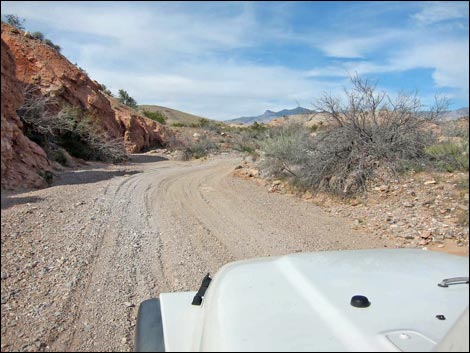
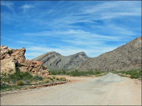 Gold Butte Road (view N departing Whitney Pocket) |
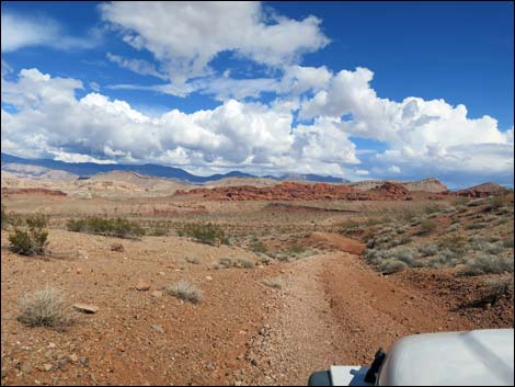
Overview Sand Wash--Mud Wash Loop is a 27-mile, 4WD driving adventure that circumnavigates Bitter Ridge. The loop departs the popular camping area of Whitney Pocket, runs west to loop south around the far end of Bitter Ridge, and returns up Mud Wash to Whitney Pocket. The loop uses several roads ranging in quality from the paved Gold Butte Road (ATVs can bypass the paved section) to washed out roads where drivers simply follow a wash. In the text below, the loop is described in general with links to details of each road. This loop runs through the Mojave Desert Scrub life zone and provides a nice introduction to the ecology of desert plants. Notice along the loop as the vegetation changes from a dense and diverse hillside flora with Joshua trees, to desert washes and springs with water-loving species, to sparsely vegetated dry bajadas where few species can survive. This is all desert, but slight differences in moisture make differences in the survival of these desert adapted plants. Link to road map. |
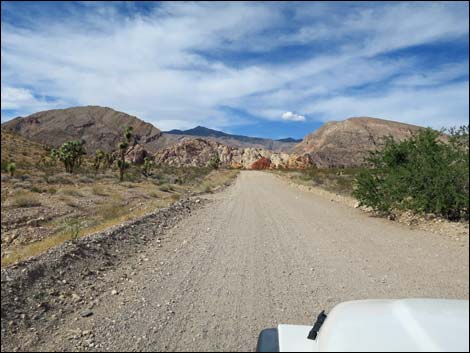
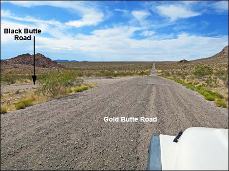 Gold Butte Road at Black Butte Road (view NW) |
Watch Out Other than the standard warnings about being in the desert, ... this loop is fairly safe with no unusual hazards. In two short sections, where Narrows Road North drops into Mud Wash and along Mud Wash Shortcut Road, the roadway is rather steep and narrow as it clings to the cliffs, but careful drivers should not have too much trouble, although both are easier in narrow vehicles. This is wild and remote country without services of any kind (no restrooms, no water, no gas, no food). Bring what you need to survive. Be prepared and be self-reliant. It is a big place, but someone will eventually find you if you stay on a main road, but be prepared to survive alone for a day or two, or even longer on side roads. Cell phones probably work towards the west end of the loop. While out, please respect the land and the other people out there, and try to Leave No Trace of your passage. Also, this is a remote area, so be sure to bring the 10 Essentials. |
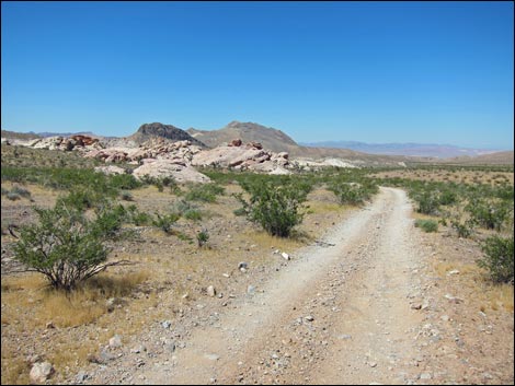 Black Butte Road approaching the Falling Man area (view SW) |
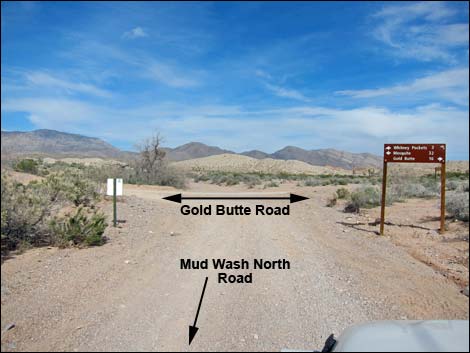
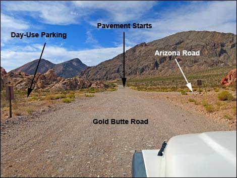
Getting to the Roadhead The Sand Wash--Mud Wash Loop is located out in Gold Butte northeast of Lake Mead, about 2 hours northeast of Las Vegas. From Las Vegas, drive out the paved Gold Butte Road 21 miles to the end of the pavement at Whitney Pocket. Continue south on the unpaved Gold Butte Road about 100 yards to a spur road to the right that leads into the day-use parking area. Turn right and park here; this is the start and end of the Sand Wash--Mud Wash Loop. |
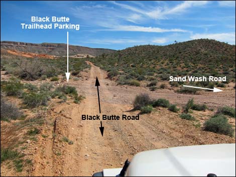 Black Butte Road at Sand Wash Road (view SE) |
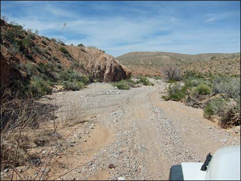
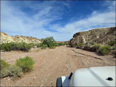
The Loop From Whitney Pocket (Table 1, Site 0462), the Sand Wash--Mud Wash Loop heads north on the paved Gold Butte road for about 1.4 miles to Black Butte Road (Site 1004), on the left. Making a hard left onto Black Butte Road, the loop begins the long leg west. At about 1.9 miles out, the road passes the parking corral for the Falling Man petroglyph site. The short walk out to the rock art panels is worth the time. Continuing another 1.6 miles, Black Butte Road crosses Sand Wash (Site 1666). At Sand Wash, the loop turns right and starts down Sand Wash Road, which just follows the wash for about 2.2 miles. From there, Sand Wash Road leaves the wash and generally runs west across the desert parallel to Sand Wash. About 4.3 miles out Sand Wash Road, the road forks (Site 1629). Drivers can take either fork, as the two eventually rejoin. The left is the shorter and easier choice, while the right drops into and eventually climbs back out of, Sand Wash. |
 Sand Wash Road (view SE) |
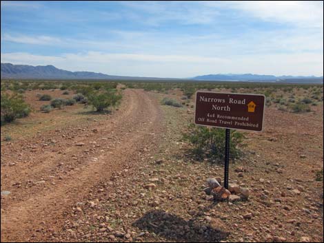
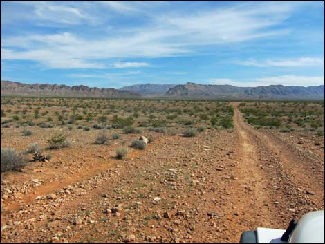
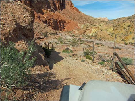
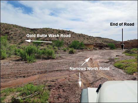
Taking the left fork, Sand Wash Road ends in another 1.1 miles at a T-intersection with Narrows Road North (Site 1632). At this intersection, the road from the right is the other fork of Sand Wash Road. Turning left onto Narrows Road North, which is in Lake Mead National Recreation Area, the loop heads generally southeast across flat, open terrain. While the first 3.3 miles might be uninspiring, the scenery is grand, the last 0.4 miles of the road provides enough excitement to make up for the other miles. The last 0.2 miles are also back outside Lake Mead NRA. Drivers should slow down and take it easy when the road starts to wind down along the cliff into Mud Wash. The historic barbed wire fence provides some psychological support, but it would never hold a vehicle that slid off the edge. Narrows Road North hits the bottom of Mud Wash (Site 1633) and turns right to head downstream through an area that often is wet. |
 Sand Wash Road at Narrows Road North (view S) |
Note that at this point, Mud Wash upstream is blocked by a post and cable fence to protect Red Bluff Spring. Over the years, cattle and vehicles damaged the riparian habitat making it less suitable for wildlife and rare plants. Because water in the desert is so rare, land managers blocked the road to allow the habitat to recover. The loop continues, but not up through Red Bluff Spring. Driving downstream through the water, in about 200 yards, Narrows Road North reaches Gold Butte Wash Road (Site 1634), on the left. The loop turns left here and continues southeast as it runs up Gold Butte Wash. This canyon flash flooded in about 2012, so now the road simply runs up the wash. At about 0.9 miles up Gold Butte Wash, the loop reaches the edge of Lime Canyon Wilderness Area, on the right. From here to the end of Gold Butte Wash Road (1.4 miles), the top of the bluffs mark the edge of the wilderness area. |
 Narrows Road North (view SE) |
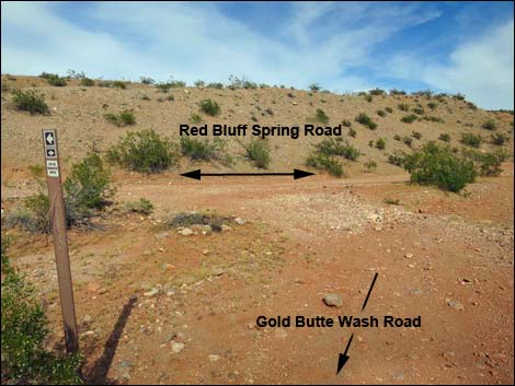
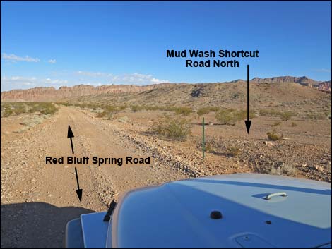
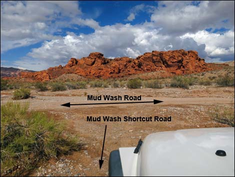
Gold Butte Wash Road eventually ends at a T-intersection (Site 1624) with Red Bluff Spring Road. Turning left, the loop runs north to climb out of Gold Butte Wash. Just after reaching the desert flats above, after less than 200 yards on Red Bluff Spring Road, the loop reaches another T-intersection (Site 1625), this time on the right with Mud Wash Shortcut Road. [Note that while the loop turns right here, it is possible to continue north to Mud Wash (upstream from the upper fence protecting Red Bluff Spring) and follow Mud Wash Road upstream to reconnect with the loop.] The T-intersection (Site 1625) is a bit goofy. After turning right onto Mud Wash Shortcut Road, the road splits after only 10 yards. Mud Wash Shortcut Road stays left to run northeast. The road climbs over a saddle with grand views east, then drops back into the Mud Wash drainage system. There are some tight turns and narrow spots along this road, so drive carefully when you can't see the road ahead. |
 Narrows Road North dropping into Mud Wash (view NE) |
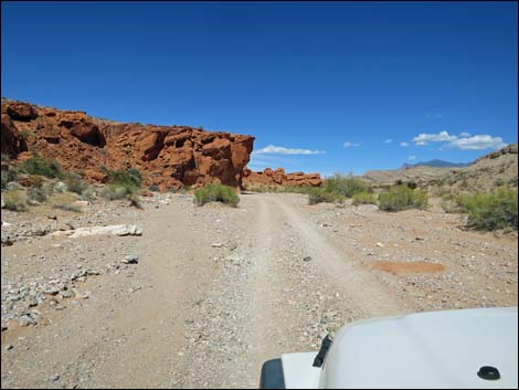
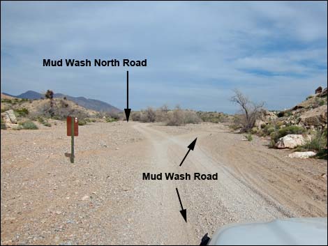
Mud Wash Shortcut Road eventually winds down dirt cliffs into Mud Wash and reaches a T-intersection with Mud Wash Road (Site 1678). Turning right, the route heads up Mud Wash for 1.3 miles, passing a nice rock art site along the way. The road runs through a gap in the mountains and arrives at a major fork in the wash (Site 1676). At the fork, Mud Wash Road stays right and can be used to visit Devils Throat and reach unpaved Gold Butte Road beyond, but the loop stays left to head up the North Fork of Mud Wash following Mud Wash North Road. Running up Mud Wash North Road for 3.2 miles, the loop reaches another T-intersection (Site 1649), this time with unpaved Gold Butte Road. Turning left onto the "super highway," the loop runs northeast 3.9 miles to return to Whitney Pocket (0462) and close the loop. |
 Narrows Road North at Gold Butte Wash Road (view NE) |
 Gold Butte Wash Road (view SE) |
 Gold Butte Wash Road at Red Bluff Spring Road (view E) |
 Red Bluff Spring Road at Mud Wash Shortcut Road (view N) |
 High saddle on Mud Wash Shortcut Road (view E) |
 Mud Wash Shortcut Road at Mud Wash Road (view N) |
 Mud Wash Road approaching rock art site (view N) |
 Mud Wash Road at Mud Wash North Road (view E) |
 Mud Wash North Road (view NE) |
 Mud Wash North Road at Gold Butte Road (view NE) |
 Gold Butte Road approaching Whitney Pocket (view NE) |
 Gold Butte Road at Whitney Pocket; end of the loop (view N) |
Table 1. Highway Coordinates Based on GPS Data (NAD27; UTM Zone 11S). Download Highway GPS Waypoints (*.gpx) file.
| Wpt. | Location | Latitude (N) | Longitude (W) | Elevation (ft) | Point-to-Point Distance (mi) | Cumulative Distance (mi) | Verified |
|---|---|---|---|---|---|---|---|
| 0462 | Gold Butte Rd at Whitney Pass Road | 36.52333 | 114.13919 | 3,013 | 0.00 | 00.00 | Yes |
| 1004 | Gold Butte Rd at Black Butte Rd | 36.53039 | 114.16102 | 2,776 | 1.45 | 01.45 | Yes |
| 1006 | Black Butte Rd at Falling Man Trailhead | 36.51165 | 114.18454 | 2,393 | 1.93 | 03.38 | Yes |
| 1666 | Black Butte Rd at Sand Wash Rd | 36.49791 | 114.20377 | 2,219 | 1.60 | 04.98 | Yes |
| 1629 | Sand Wash Road forks | 36.49921 | 114.27245 | 1,727 | 4.35 | 09.33 | Yes |
| 1632 | Sand Wash Road at Narrows North Road | 36.49904 | 114.29198 | 1,571 | 1.10 | 10.43 | Yes |
| 1633 | Narrows Road North at Mud Wash | 36.46062 | 114.25826 | 1,574 | 3.53 | 13.96 | Yes |
| 1634 | Narrows Road North at Gold Butte Wash Road | 36.46025 | 114.25991 | 1,556 | 0.13 | 14.09 | Yes |
| 1624 | Red Bluff Spring Rd at Gold Butte Wash Rd | 36.44140 | 114.23124 | 1,884 | 2.27 | 16.36 | Yes |
| 1625 | Red Bluff Spring Rd at Byway Shortcut Rd S | 36.44286 | 114.23152 | 1,908 | 0.10 | 16.46 | Yes |
| 1678 | Mud Wash Rd at Mud Wash Shortcut Rd | 36.43659 | 114.20652 | 1,962 | 1.95 | 18.41 | Yes |
| 1676 | Mud Wash Rd at Mud Wash North Rd | 36.44311 | 114.18815 | 2,090 | 1.31 | 19.72 | Yes |
| 1649 | Gold Butte Rd at Mud Wash North Rd | 36.47546 | 114.16339 | 2,388 | 3.16 | 22.88 | Yes |
| 0462 | Gold Butte Rd at Whitney Pass Road | 36.52333 | 114.13919 | 3,013 | 3.85 | 26.73 | Yes |
Happy Hiking! All distances, elevations, and other facts are approximate.
![]() ; Last updated 240326
; Last updated 240326
| Backroads Around Las Vegas | Hiking Around Las Vegas | Glossary | Copyright, Conditions, Disclaimer | Home |