Backroads Around Las Vegas, Gold Butte
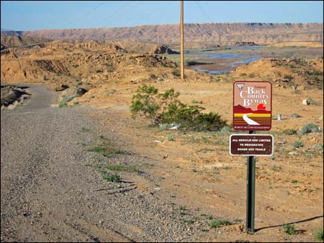 Backcountry Byway route sign (view W) |
Overview Gold Butte Backcountry Byway is a 99-mile scenic drive that starts near the town of Mesquite, heads south into the wild and rugged Gold Butte region, and returns to the highway. This is a partial loop adventure and cannot be considered a through-route to anywhere else. The Backcountry Byway runs out in the backcountry where the scenery is grand, the expanse is vast, and the wildness is almost pristine. There are five sections of the adventure: (1) paved Gold Butte Road (rough road), (2) unpaved Gold Butte Road (rough graded road), (3) Red Bluff Spring Road (sometimes graded), (4) Mud Wash Road (two-track in a sand-and-gravel wash), and (5) returning to the highway via the unpaved Gold Butte Road and paved Gold Butte Road. |
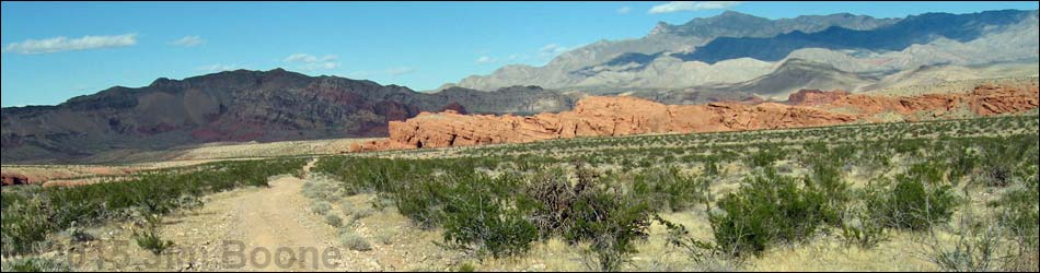
 Unpaved Gold Butte Road (view S towards southern Gold Butte) |
Driving the entire byway takes a day and requires a 2WD-HC vehicle, although driving uphill on Mud Wash Road is always a bit of a concern in the sand and gravel where 4WD would be safer. Red Bluff Spring Road northbound requires only 2WD medium-clearance vehicles, and Gold Butte Road can be driven in a sedan as far as Gold Butte Townsite. The Backcountry Byway forms a partial loop, and the loop can be driven in either direction. Driving the loop as described requires only 2WD, but driving the other direction (southbound on Red Bluff Spring Road) requires climbing several steep hills that are easier with 4WD, but the road was "graded" in April 2017 and is now less difficult. Link to map. |
 Sand and gravel in Mud Wash (view E) |
Watch Out Other than the standard warnings about being in the desert, ... the byway is fairly safe and without any unusual hazards. There are a few tight, blind curves to navigate carefully, and the sand and gravel in Mud Wash could be a problem without 4WD. This is wild and remote country without services of any kind (no restrooms, no water, no gas, no food). Bring what you need to survive. Be prepared and be self-reliant. It is a big place, but someone will eventually find you if you stay on a main road, but be prepared to survive alone for a day or two, or even longer on side roads. Cell phones don't work along most of the byway. While out, please respect the land and the other people out there, and try to Leave No Trace of your passage. Also, this is a remote area, so be sure to bring the 10 Essentials. |
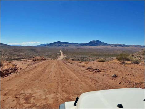
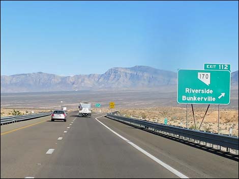 Interstate 15 at Highway 170 exit (view E) |
Getting to Gold Butte Backcountry Byway The Gold Butte Backcountry Byway is located out in Gold Butte northeast of Lake Mead, beginning about 1 hour northeast of Las Vegas. From Las Vegas, drive north on Interstate-15 for about 70 miles to Highway 170 (Exit 112 to Riverside and Bunkerville). This exit is about 5 miles south of (before) Mesquite, but consider stopping in Glendale or continuing to Mesquite to top off the gas tank before leaving the highway. The official Gold Butte Backcountry Byway starts on the I-15 off-ramp (Table 1, Site 0684). |
 Highway 170 at Gold Butte Road (paved) sign (view W) |
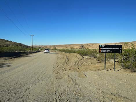
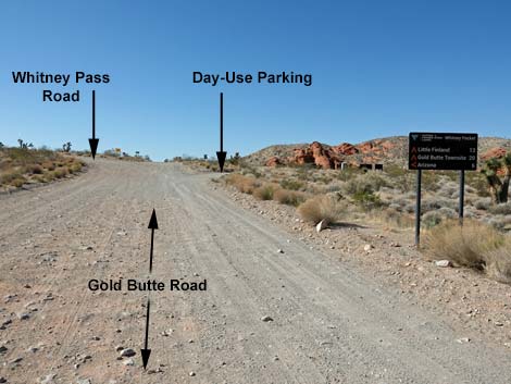
Backcountry Byway - Segment 1: Paved Gold Butte Road. The adventure begins as Highway 170 runs south and descends into the Virgin River Valley. The tall peak in the background is Virgin Peak (8,063 ft). The highway crosses the river, and immediately across the bridge, the unsigned Gold Butte Road (Site 0686) turns to the right. Gold Butte Road is the gateway to the wild and rugged Gold Butte region. The first 21 miles are paved, although it is a bit rough with many potholes, a lot of patch, and two washouts. The road runs west along the river, then eventually bends south and climbs onto the flanks of Virgin Peak. Long stretches of open desert along the west side of the Virgin Mountains lead to Whitney Pocket, an historic and scenic area where people often camp among colorful red and white sandstone crags. The pavement ends (Site 0461) as drivers enter the Whitney Pocket area. For details of this portion of the Backcountry Byway, see paved Gold Butte Road. |
 Start of unpaved Gold Butte Road (view S) |
Backcountry Byway - Segment 2: Unpaved Gold Butte Road. Past Whitney Pocket (Site 0461), the unpaved Gold Butte Road continues south as a two-lane dirt road, and here the real wildness begins. The occasionally maintained road runs through spectacular country and leads to places such as Gold Butte Townsite, Devils Throat, Scanlon Dugway, and a whole lot of grand scenery. The road runs generally downhill into Mud Wash Valley, then climbs along the east side of Tramp Ridge to the Townsite. There are several major intersections, but in general, the road runs straight south and southwest for 20 miles, staying right at two major forks until reaching the historic Gold Butte Townsite at the southern-most point on the byway.This segment ends at Gold Butte Townsite where the signed Red Bluff Spring Road (Site 0806) turns right. For details of this portion of the Backcountry Byway, see unpaved Gold Butte Road. |
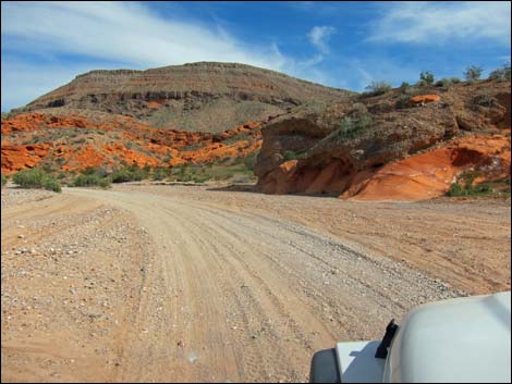
 Gold Butte Road approaching Red Bluff Spring Road (view W) |
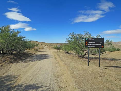
Backcountry Byway - Segment 3: Red Bluff Spring Road. From Gold Butte Townsite, Red Bluff Spring Road (Site 0806) runs northwest as it descends across desert flats towards the South Fork of Lime Wash. Generally following the wash, the road runs north between Tramp Ridge to the east and Lime Ridge to the west. Lime Ridge is in the Lime Canyon Wilderness Area, and Lime Canyon Road, marked by a large wilderness area sign, leads down to the mouth of Lime Canyon and a great hike down the narrow canyon. Beyond Lime Canyon Road, the byway continues north following the North Fork of Lime Wash until climbing over a saddle and descending into Gold Butte Wash. Generally following Gold Butte Wash, again between Lime Ridge and Tramp Ridge, Red Bluff Spring Road winds down the valley and past red sandstone outcrops until dropping steeply into Mud Wash. This segment ends where Red Bluff Spring Road drops into Mud Wash (Site 1685) and Mud Wash Road goes right and up the wash. For details of this portion of the Backcountry Byway, see Red Bluff Spring Road - Northbound. |
 Red Bluff Spring Road approaching Mud Wash Road (view N) |
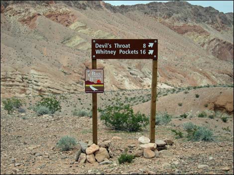
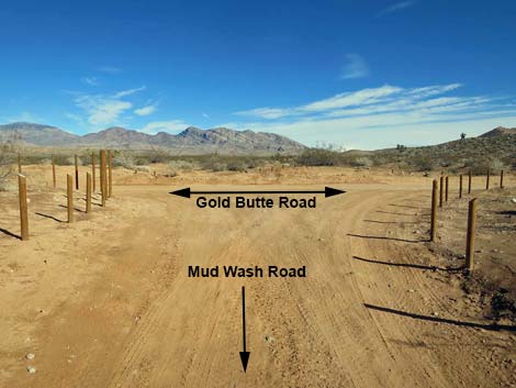
Backcountry Byway - Segment 4: Mud Wash Road. In Mud Wash (Site 1685), it is a short walk downstream past a fence to Red Bluff Spring, but Mud Wash Road heads upstream to the right. In the sandy wash, Mud Wash Road passes Little Finland Road, which goes left towards the world famous playground, and then passes the historic Mud Wash Corral and Mud Wash Rock Art Site. Mud Wash Road passes minor side roads, but eventually it arrives at a major fork (Site 1676). Here, drivers have a choice: the byway stays right, while the shorter Mud Wash North Road goes left. Turning left on Mud Wash North Road, drivers arrive at unpaved Gold Butte Road (Site 1649) in 3.2 miles. Staying on the byway, drivers stay left at all forks, but pass two short spur roads right to Devils Throat (about 3 miles from the fork), and then arrive back at the unpaved Gold Butte Road (Site 0807). For details of this portion of the Backcountry Byway, see Mud Wash Road, and optionally, Mud Wash North Road. |
 Mud Wash Road approaching Gold Butte Road (view E) |
Backcountry Byway - Segment 5: Returning to Interstate-15 Mud Wash Road dead-ends into the unpaved Gold Butte Road and closes the loop. Turing left, the driving adventure heads north over familiar terrain. After about 3.3 miles, Gold Butte Road passes the turnoff to Mud Wash North Road, then continues over 4 bumpy miles to Whitney Pocket where the pavement begins (Site 0461). Driving north on paved Gold Butte Road, the road eventually dead-ends onto Highway 170 (Site 0686). Drivers might want to turn right and head into Mesquite for food and fuel, otherwise, turning left, Highway 170 crosses the Virgin River and runs up the hillside to merge with Interstate-15 (Site 0684) southbound towards Las Vegas. For details of this portion of the Backcountry Byway, see unpaved Gold Butte Road and paved Gold Butte Road. |
Table 1. Highway Coordinates and Distances based on GPS Data (NAD27). Download Highway GPS Waypoints (gpx) file.
| Wpt. | Location | Latitude (N) | Longitude (W) | Elevation (ft) | Point-to-Point Distance (mi) | Cumulative Distance (mi) | Verified |
|---|---|---|---|---|---|---|---|
| 0684 | Hwy I-15 at Hwy 170 | 36.77063 | 114.23374 | 1,804 | 00.00 | 00.00 | Yes |
| 0686 | Hwy 170 at Gold Butte Rd | 36.73179 | 114.21724 | 1,444 | 03.56 | 03.56 | Yes |
| 0461 | Gold Butte Rd at End of Pavement | 36.52425 | 114.13964 | 3,023 | 21.07 | 24.63 | Yes |
| 0806 | Gold Butte Rd at Red Bluff Spring Rd | 36.28093 | 114.20028 | 3,727 | 20.23 | 44.86 | Yes |
| 1685 | Red Bluff Spring Rd at Mud Wash Rd | 36.46288 | 114.25081 | 1,653 | 14.57 | 59.43 | Yes |
| 1676 | Mud Wash Rd at Mud Wash North Rd | 36.44311 | 114.18815 | 2,090 | 05.11 | 64.54 | Yes |
| 0807 | Gold Butte Rd at Mud Wash Rd | 36.43258 | 114.14300 | 2,244 | 02.97 | 67.51 | Yes |
| 1649 | Gold Butte Rd at Mud Wash North Rd | 36.47546 | 114.16339 | 2,388 | 03.31 | 70.82 | Yes |
| 0461 | Gold Butte Rd at End of Pavement | 36.52425 | 114.13964 | 3,023 | 03.91 | 74.73 | Yes |
| 0686 | Gold Butte Rd at Hwy 170 | 36.73179 | 114.21724 | 1,444 | 21.07 | 95.80 | Yes |
| 0684 | Hwy 170 at Hwy I-15 | 36.77063 | 114.23374 | 1,804 | 03.56 | 99.36 | Yes |
Happy Hiking! All distances, elevations, and other facts are approximate.
![]() ; Last updated 240326
; Last updated 240326
| Backroads Around Las Vegas | Hiking Around Las Vegas | Glossary | Copyright, Conditions, Disclaimer | Home |