Hiking Around Las Vegas, Grand Canyon National Park
 Start of the Thunder River Trail (view SW from trailhead parking) |
Overview The Ghost Rock Route provides a great hike from the North Rim down to the Esplanade and on to an interesting archeological site. The route follows the Thunder River trail from the trailhead to a point just above the Esplanade. The trail is easy to follow, but it is not maintained and there are plenty of places to stumble off the cliffs. On the Esplanade, the off-trail hiking is not as easy as one might expect. Ghost Rock has been used by humans for a long time. Ancient people left petroglyphs, the pictographs for which the site is named, pot shards, stone flakes, and other evidence; cowboys left metal cans and other trash. The trailhead is not actually in Grand Canyon National Park, rather it is located on the Kaibab National Forest where regulations are less restrictive. For example, access to the area is free and camping is permitted anywhere. The Indian Hollow Campground provides three sites with picnic tables and a vault toilet. Link to trail map or elevation profile. |
 Grand Canyon overlook (view S) |
Watch Out Other than the standard warnings about hiking in the desert, ...this trail is fairly safe, but the long traverse between the Kaibab and Toroweap cliffs is open and airy with precipitous drop-offs and dicey rockslides. While not a dangerous trail, falls from many places would be quite damaging. While hiking, please respect the land and the other people out there, and try to Leave No Trace of your passage. Also, this is a long hike in a remote area, so bring the 10 Essentials. Consider caching water for the hike out. All of the access roads are signed and maintained for sedans, but rain, snow, and fallen trees can make the roads temporarily impassable. |
 Ghost Rock (view SW from the overlook) |
Getting to the Trailhead
This hike is located on the North Rim of the Grand Canyon, about 7 hours northeast of Las Vegas. From Las Vegas, drive out to the North Rim of Grand Canyon National Park. From the intersection of Hwy 389 and Hwy Alt 89 in Fredonia, Arizona, turn right onto Hwy Alt 89 and drive east for 1.5 miles to Forest Road (FR) 422 (Table 1, Site# Road 1). Turn right onto FR422 and drive south forever. The road is paved for about 22 miles. At mile 27.2, the gravel road passes Big Springs Ranger Station (Site# Road 2). Piped drinking water is available along the edge of the road by the big pond (outside the fence) just south of the gate into the ranger station area. Continue south for a total of 32.2 miles to FR425 (Site# Road 3). At FR425, turn right towards Crazy Jug Point and drive west and south for 8.4 miles to FR232 (Site# Road 4). Turn right onto FR232 and drive west for 4.7 miles to Indian Hollow Campground (Site# Road 10). Continue west for another 0.4 miles to the end of the road. Park here; this is the trailhead (Site# Road 9). |
 Traversing hillsides between Kaibab and Toroweap cliffs (view W) |
The Hike From the Indian Hollow Trailhead (Table 2, Waypoint 1), the trail crosses a wash at the edge of the parking area and heads south following the canyon downstream. After only a few minutes, the trail leaves the side of the wash and climbs onto a ridge with a grand view of the Grand Canyon (Wpt. 2). From the overlook, the trail drops quickly on a couple of short switchbacks, then begins a long traverse to the west across the top of the Toroweap cliffs. The trail on the 1/2-mile traverse is clear and easy to follow, but it has not been maintained in years, and parts are washing away. The trail is not dangerous, but from many places along the traverse, a stumble off the trail could be your last. After the traverse, the trail drops steeply through a gap in the Toroweap and Coconino cliffs. The Coconino is particularly thin at this point. A rock fall wiped out part of the trail, but it is fairly easy to negotiate the rocks and regain the trail lower down. |
 Dropping through Toroweap and Coconino cliffs (view SW) |
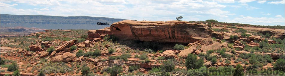
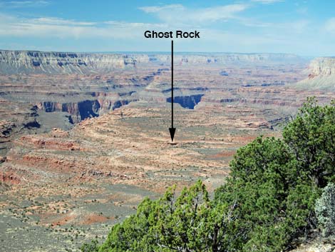
Below the cliffs, there are a few more switchbacks in the Hermit Shale, and then the trail turns and runs more-or-less straight down the hillside to a trail sign (Wpt. 5) along the trail. The Thunder River Trail turns here and runs off to the east, but the route to Ghost Rock continues straight down the slope, eventually running around the east side of a red hill. Alternatively, one can hike around the west side of the red hill, but either way, there is a nice rock shelter with a tree for shade on the south side of the red hill (Wpt. 5). From the rock shelter (Wpt. 5), Ghost Rock is about 1 air-mile southwest. There is not a quick and simple what to get there, but contouring around on the Esplanade slickrock and climbing across gullies is as good as it gets. Ghost Rock (Wpt. 6) is a large, red, overhanging rock with to life-size pictographs painted high on an overhanging wall. The two ghostly characters are quite intriguing. These pictographs are about life size and higher on the wall than I could reach. Perhaps they use a long-handled paintbrush. Below the ghost there are two small mortar depressions that are similar to those used for mixing paint and sacred herbs in southern Nevada. There is also a lot of charcoal in the dirt, suggesting lots of fires, but there are no smoke stains on the wall. |
 Trail running down hillside in the Hermit Shale (view SW) |
To the south of the ghosts, there are some interesting petroglyphs that show circles and interlocking semi-circles. North of the ghosts appears to be a large living area. The floor is littered with pot shards, stone flakes, and a few small stone tools. Evidence here suggests long use from native peoples, cowboys, and hikers. Keep an eye out for old and older artifacts out on the Esplanade. Note the various construction types (smooth, coils, and scallops), painted and unpainted, and different paint styles. Stone flakes and stone scrapers (white, upper right) were common. The horseshoe was well worn, and we found cowboy charcoal sketches on rock walls dating from 1935. We located some stonework (walls and enclosures), but these might date from the cowboy days. In the right season, there are many tinajas on the Esplanade. Check the tinajas for aquatic invertebrates such as fairy shrimp, possibly clam shrimp, midge larvae, and other creatures. |
 Trail sign at the turn in the Thunder River Trail (view N) |
We also saw Desert Spiny Lizards, Sagebrush Lizards, Rock Wrens, Say's Phoebes, and Scott's Orioles along the trail. Back at the overlook at the end of our long day, we were treated to 10 minutes or so of the antics of a Peregrine Falcon chasing bats in the evening light. When finished communing with the ghosts and the people where were here before you, head back to the shady rock and then back out the Thunder River Trail. Alternatively, wander off into the Esplanade and find another way back to the rim. |
 Hiker atop the shady rock (view NE) |
 Tinajas out on the Esplanade (view E) |
 Approaching Ghost Rock: still a ways off (view SW) |
 Hiker in "living area" beneath Ghost Rock overhang (view S) |
 The ghosts (view W) |
 Petroglyphs (view N) |
 Old and older artifacts on the Esplanade |
 Collared Lizard on limestone boulder far down in the Hermit Shale |
Table 1. Highway Coordinates (NAD27, UTM Zone 12S). Note: these are UTM Zone 12 Download GPS Waypoints (*.gpx) file.
| Site # | Location | Latitude (N) | Longitude (W) | UTM Easting | UTM Northing | Elevation (ft) | Verified |
|---|---|---|---|---|---|---|---|
| Road 1 | Alt89 at FR422 | 36.93418 | -112.50358 | 366094 | 4088423 | 4,835 | GPS |
| Road 2 | Big Spring Ranger Station (water) | 36.60269 | -112.34985 | 379267 | 4051445 | 6,925 | GPS |
| Road 3 | FR422 at FR425 | 36.53585 | -112.33684 | 380328 | 4044014 | 7,606 | GPS |
| Road 4 | FR425 at FR232 | 36.46535 | -112.40918 | 373738 | 4036286 | 6,868 | GPS |
| Road 9 | Indian Hollow Trailhead | 36.45904 | -112.48759 | 366701 | 4035691 | 6,261 | GPS |
| Road 10 | Indian Hollow Campground | 36.46233 | -112.48335 | 367086 | 4036051 | 6,313 | GPS |
Table 2. Hiking Coordinates (Waypoints; NAD27; UTM Zone 12S). Note: these are UTM Zone 12. Download GPS Waypoints (*.gpx) file.
| Wpt. | Location | Easting | Northing | Elevation (ft) | Point-to-Point Distance (mi) | Cumulative Distance (mi) | Verified |
|---|---|---|---|---|---|---|---|
| 01 | Trailhead | 366709 | 4035681 | 6,247 | 0.00 | 0.00 | GPS |
| 02 | Overlook | 366527 | 4035461 | 6,267 | 0.21 | 0.21 | GPS |
| 03 | Top of Switchbacks | 365493 | 4035275 | 5,927 | 0.55 | 0.76 | GPS |
| 04 | Leave Trail | 365789 | 4034613 | 5,144 | 0.92 | 1.68 | GPS |
| 05 | Shady Rock | 365610 | 4034269 | 4,978 | 0.28 | 1.96 | GPS |
| 06 | Ghost Rock | 364430 | 4033556 | 4,810 | 1.23 | 3.19 | GPS |
| 01 | Trailhead | 366709 | 4035681 | 6,247 | 3.19 | 6.38 | GPS |
Happy Hiking! All distances, elevations, and other facts are approximate.
![]() ; Last updated 240326
; Last updated 240326
| Hiking the Grand Canyon | Hiking Around Las Vegas | Glossary | Copyright, Conditions, Disclaimer | Home |