Hermits Rest to Boucher Camp
Hiking Around Las Vegas, Grand Canyon National Park
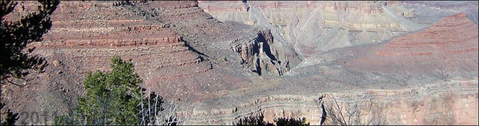
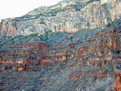
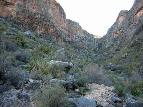
 Boucher Trail runs above red cliffs in Hermit Canyon (view NW) |
Overview The Boucher (pronounced boo-shay') is a tough, 9-mile trail that rewards hikers with grand views down Hermit Canyon and out across the Grand Canyon. The trail was built by Louis Boucher, the hermit for whom Hermits Rest, Hermit Canyon, and Boucher Canyon were named. Despite the reputation, keep in mind that old-man Boucher routinely ran his mules up and down this trail. The trail starts at Hermits Rest and follows the Dripping Springs Trail into the mouth of Dripping Springs Canyon. The trail then runs out the west side of Hermit Canyon just below the Coconino Sandstone and circles around Yuma Point into Travertine Canyon. Near the back of Travertine Canyon, the trail drops steeply through a break in the highest Supai cliffs, then resumes the contour into the back of the canyon. The trail descends a steep dirt hillside with many use-trails towards the bottom of the gorge, then cuts steeply down a dirt ridge along the east side of the wash. At the lip of the Redwall, the trail crosses Travertine Wash and runs out the west side of Travertine Canyon to a saddle south of White’s Butte. Descending short, steep switchbacks, the trail drops through the Redwall to the Tonto Trail. From the trail junction, the Boucher Trail follows the Tonto Trail west into Boucher Camp. |
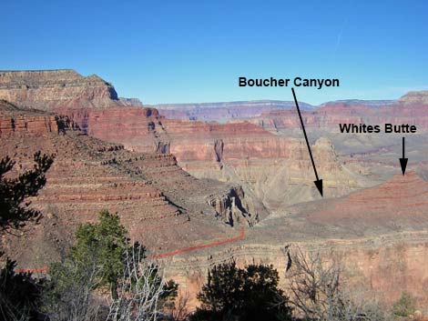 White's Butte and trail to gap in Red Wall (view W from Yuma Point) |
There are differences of opinion about the Boucher Trail: some authors have written that hiking down the Boucher is crazy, while others have written that hiking up is crazy. Perhaps these authors were off-route, but there is, in fact, a trail the entire way from Hermits Rest to Boucher Camp. Make no mistake, the trail is tough, many parts are steep and rocky, and some parts are quite exposed, but there is no need to lower packs using ropes or to cling to the cliff face with your toenails. At the one scramble-down, I turned to face into the rock, but only to avoid the possibility of having my 50-pound backpack catch on a rock -- I could have done it facing out. People often hike this trail as part of a 3- or 4-day backpacking loop using the Boucher, Tonto, and Hermit trails. The loop is popular, so plan ahead and make backcountry reservations early. Camping is "at large" in the Boucher Zone (BN9), so you can camp anywhere. Permanent water is available only in Boucher creek, but this isn't necessarily the best place to camp. Link to map. |
 Trail in back of Travertine Canyon (view SW from above the first cliffs) |
Watch Out Other than the standard warnings about hiking in the desert, ...this trail is tough, many parts are steep and rocky, and some parts are quite exposed. There is one, exposed 3rd-class scramble down, and there are many places to stumble off the trail and fall into the abyss, never be seen again. Hiking down, plan to carry enough water to get from Hermits Rest to Boucher Creek. Hiking up, it probably is worth the 0.8-mile round-trip to Dripping Springs to get water. The inner canyon can be very hot; plan accordingly. While hiking, please respect the land and the other people out there, and try to Leave No Trace of your passage. This is a fairly long hike, so be sure to bring the 10 Essentials. Be sure that you are physically fit and that you choose routes of the appropriate difficulty for your skills and endurance. Getting to the Trailhead This hike is located on the South Rim of the Grand Canyon, about 5 hours southeast of Las Vegas. From town, drive out to the South Rim of Grand Canyon National Park. From the South Rim Visitor Center (Table 1, Site 811), ride the shuttle bus or drive to the Hermits Rest trailhead (Site 815), which is at the end of the road west of the South Rim Village area. The trailhead is just west (past) of the Hermits Rest buildings. When the shuttle bus is running (spring through fall), take it to Hermits Rest. Walk past the tourist facilities and past the housing area to the end of the road. Either walk past the restrooms and down the gravel road, or walk past the Hermits Rest building and out the trail along the rim. It is about 0.25 miles from the bus stop to the trailhead. When the shuttle is not running, drive to the trailhead or arrange for a taxi. |
 Trail above and below cliffs on E side of Travertine Canyon (view NE) |
The Hike From the trailhead (Table 2, Waypoint 1), the trail runs off the edge of the rim and starts down a side canyon, switchbacking quickly into the Kaibab Limestone. It takes about 5 minutes to get to the best of the Kaibab fossils, and in another 5 minutes, you round a corner and suddenly the expanse of the Grand Canyon opens up in front of you. Below the Kaibab Limestone, the trail descends at a moderate grade through the Toroweap Formation. About 30 minutes out, the trail runs out to a ridgeline and starts [0753] down into the Coconino Sandstone on a long series of steep switchbacks paved with sandstone blocks. |
 Easy hiking atop Red Wall (view N) |
At about 1.2 miles out, the trail passes an area with fossilized tracks in sandstone slabs adjacent to the trail (Wpt. 2), and tracks from several species of animals can be seen from the trail. A few minutes below the fossil tracks, the rocky trail drops below the Coconino Sandstone and runs out on dirt (Hermit Shale) as it enters Waldron Basin, a fairly broad, open, basin in the bottom of Hermit Canyon. Below the Coconino, the trail soon intersects the Waldron Trail (Wpt. 3), which runs and up the canyon (right) and hits the rim to the west of Hermits Rest; this is another way to start the hike into Hermit Canyon. Below the Waldron Trail junction, the Boucher Trail hits the bottom of the canyon, then turns north and runs downhill along the wash. Near the bottom of Waldron Basin, the Dripping Springs and Boucher trails split from the Hermit Trail (Wpt. 4). The Hermit trail continues down the wash for about 30 yards to the top edge of the Supai cliffs, while the Dripping Springs and Boucher trails turn west and climb the low hillside out of Waldron Basin. |
 Gap in the Redwall south of White's Butte (view W) |
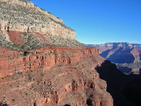
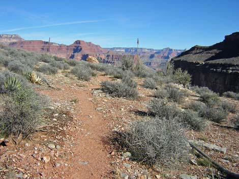
The Dripping Springs and Boucher trails run west around the head of Hermit Canyon. The trail is narrow and rocky with lots of exposure. The trail crosses two major gullies before starting up Dripping Springs Canyon. For details of this part of the trail, see the Dripping Spring Trail. Shortly after entering Dripping Springs Canyon, a sign indicates the junction where the Boucher Trail forks off to the north (Wpt. 5). The start isn't entirely obvious, but the trail becomes clear just across Dripping Springs Wash. The vegetation here is similar to that in Waldron Basin, but there is more sagebrush and a few more trees here (Wpt. 6). From Dripping Springs Wash, the Boucher Trail runs northeast along the top of the Supai cliffs. There are grand views down the steep sidehill into Hermit Canyon, grand views of the Coconino Sandstone towering above the trail, and grand views out towards the North Rim. Although the trail crosses few contour lines and is easy to follow, the hiking is tough. There is a lot of up, down, and around; but except for a few places, the exposure isn't bad. There are a few places to scramble over or around rock falls on steep hillsides and in gullies. The vegetation along the hillside is a sparse pinyon-juniper forest (Two-Needle Pinyon and Utah Juniper) with Blackbrush, Banana Yucca, and Mormon Tea -- nothing to interfere with the views into the bottom of Hermit Canyon. |
 Trail in steep gully (view down and W) |
Beneath Yuma Point (Wpt. 7), the trail crosses out of Hermit Canyon and into Travertine Canyon. The point is broad and flat, and there are said to be nice campsites out on the edge of the cliffs, but there is nowhere to camp right along the trail. From Yuma point (Wpt. 7), the trail starts into Travertine Canyon on the contour above the Supai cliffs, again providing grand views into the canyon. From along here, the trail is easy and easy to follow, and you can see the trail far below where it crosses Travertine Wash and runs out towards White’s Butte. |
 Looking back: Steep trail through the Red Wall (view up and E) |
Towards the back of Travertine Canyon (Wpt. 8), the trail starts a steep, brief descent through the upper-most of three bands of Supai cliffs. The trail is good, but parts are quite exposed, and there is a bit of old-time built trail that is starting to fall away (the trail is fine, but this adds interest). At the bottom of the cliffs, there is a 15-foot, 3rd-class scramble-down. This part seems exposed because the dirt hillside below the cliffs is quite steep, but the scrambling is not difficult and there is no need to lower packs using ropes. Although steep, this is a real trail, and remember that old-man Boucher routinely took his mules up and down this route! This surely is the spot that some other commentators say is insane and requires ropes; I found it to be exciting but rather trivial; perhaps the others were off route. |
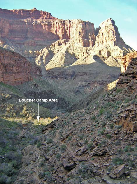 Approaching Boucher Camp (view W) |
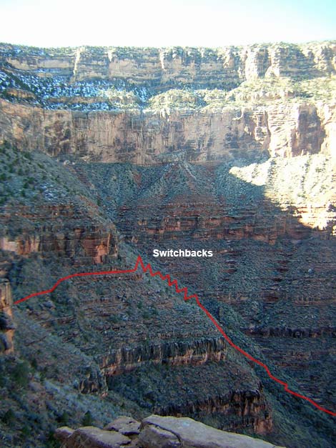
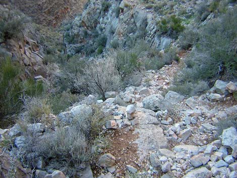
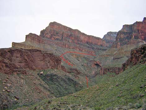
From the base of the scramble-down, the narrow trail contours around for about 10 minutes to near the back of the canyon, staying on the dirt between the highest and middle bands of Supai cliffs. At the back of the canyon, the two lower bands of cliff fade away, and the trail breaks up into many use-trails (with cairns) that descend the steep dirt hillside towards some huge boulders in the bottom of the canyon. Going down, it is easy to follow the trail because you can look down and see the trail running downhill below the huge boulders; so you can see where to go. However, hiking up, you can’t see the trail above you, so you have to simply work your way up the use-trails until you are blocked by the highest band of Supai cliffs, and the trail cuts off to the east. Going down, just before getting to the huge boulders in the bottom of the canyon, the trail turns north and runs straight down the crest of a little dirt ridge that parallels Travertine Wash. The dirt trail is steep and rocky with lots of shrubs, but it is a real trail. The trail continues steeply down the east side of Travertine Wash to the top of the Redwall, then crosses Travertine Wash (Wpt. 9) and runs up onto the far hillside. Although it looks like a gentle trail from far above, there is a lot of up-and-down on the “flats” before getting to the saddle behind White's Butte (Wpt. 10). There are some nice campsites along the ridge just before getting to the saddle, and there are additional campsites at the start of the next descent. From the saddle behind White's Butte (Wpt. 11), the trail starts a very steep descent through the Redwall Limestone into Boucher Canyon. The steep hillside funnels down to a steep and narrow gully with vertical walls. There is a trail (many short, steep, rocky switchbacks) all the way through the narrows. I wouldn't want to do it in snow, and I wouldn't want to be one of old-man Boucher's mules, but it is a fine rocky trail with little gravel and no unusual slipping or falling hazards. There are lots of shrubs and yuccas in the narrows, but it is not what I would call a shrub-choked gully. The trail winds among the shrubs and they were not a problem. |
 Looking back: trail seen from W side of Boucher Canyon |
Below the steep, rocky gully, the trail angles down and across the steep hillside below the Redwall, descending many short switchbacks, but staying higher and higher above the bottom of the gully as the canyon falls away faster than the trail. The trail is worn, but it is a fine trail. The vegetation here includes two species of yucca not seen above here: Soaptree Yucca and a Nolina (perhaps Beargrass). Near the mouth of the canyon, the trail starts switchbacking down the steep hillside. The switchbacks are mostly short and rocky, not the grand, sweeping switchbacks they appear from across the canyon. At the level of the Tonto Platform, but on a sidehill separated by a deep gully from the Tonto flats, the Boucher Trail intersects the Tonto Trail (Wpt. 12). From the junction, the trail runs steeply down the east side of the gully to the edge of the Tapeats cliffs. The trail then switchbacks very steeply down through the Tapeats. There are many loose rocks and short, steep switchbacks, and parts of the trail run right on the edge of the cliffs where old stonework holds up the trail. Old-man Boucher and his mules sure must have been tough. |
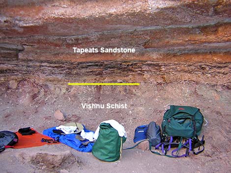 Camp at contract between Vishnu Schist and Tapeats Sandstone |
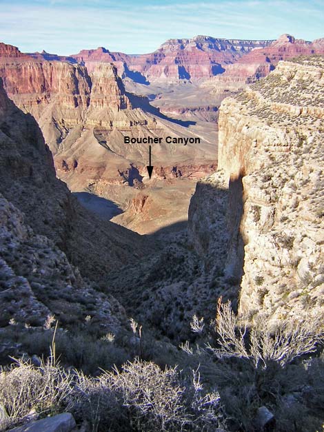
The trail drops below the Tapeats cliffs, runs west down the canyon in the Vishnu Schist, and enters the Boucher Creek camping area (Wpt. 13), which sits among boulders and under Catclaw Acacia “trees” on the edge of Boucher Creek. Several campsites are spread out along the east side of Boucher Creek. The trail enters the camping area just south of and below the ruins of Boucher's cabin, which makes the cabin hard to see from this direction. There are no developments or food storage boxes in Boucher Camp. While in the area, consider hiking down Boucher Creek to Boucher Rapids. The hike from Boucher Camp to the Colorado River is an easy, 50-minute stroll down Boucher Canyon. If you find yourself on the Tonto Trail in Boucher Canyon, this side trip is a must. In addition, this is probably the easiest route from the Tonto Trail to the river because the route starts down in the Vishnu Schist and the walking is easy. |
Table 1. Highway Coordinates (NAD27, UTM Zone 12S). NOTE: This is UTM Zone 12. Download Highway GPS Waypoints (*.gpx) file.
| Site # | Location | Latitude (°N) | Longitude (°W) | UTM Easting | UTM Northing | Elevation (feet) | Verified |
|---|---|---|---|---|---|---|---|
| 811 | Visitor Center, Canyon View Information Plaza | 36.0590 | 112.1085 | 400166 | 3990857 | 7,092 | Yes |
| 815 | Hermits Rest trailhead | 36.0604 | 112.2117 | 390870 | 3991131 | 6,642 | Yes |
Table 2. Hiking Coordinates based on GPS data (NAD27; UTM Zone 12S). Download Hiking GPS Waypoints (*.gpx) file.
| Wpt. | Location | Time* | UTM Easting | UTM Northing | Elevation (ft) | Point-to-Point Distance | Cumulative Distance |
|---|---|---|---|---|---|---|---|
| 01 | Trailhead | 07:25 | 390877 | 3991146 | 6639 | 0.00 | 0.00 |
| 02 | Fossil Tracks | 08:05 | 390220 | 3990547 | 5659 | 1.05 | 1.05 |
| 03 | Waldron Trail | 08:14 | 390082 | 3990539 | 5420 | 0.20 | 1.25 |
| 04 | Hermit Trail junction | 08:22 | 389772 | 3990625 | 5203 | 0.30 | 1.55 |
| 05 | Dripping Spring Trail | 08:58 | 388709 | 3991145 | 5210 | 1.12 | 2.66 |
| 06 | Breakfast, Start | 09:07 | 389044 | 3991340 | 5236 | 0.30 | 2.96 |
| 06 | Breakfast, End | 09:27 | 389044 | 3991340 | 5236 | . | . |
| 07 | Yuma Point | 10:51 | 389530 | 3993873 | 5416 | 2.19 | 5.15 |
| 08 | First Supai cliffs, top | 11:16 | 388767 | 3993394 | 5319 | 0.74 | 5.88 |
| 08 | First Supai cliffs, bottom | 11:24 | 388767 | 3993394 | 5319 | . | . |
| 09 | Travertine Wash | 12:09 | 388671 | 3993888 | 4438 | 0.83 | 6.72 |
| 10 | Flats before Whites Butte | 12:34 | 388945 | 3994715 | 4524 | 0.73 | 7.45 |
| 11 | Gap in Redwall, Arrive | 12:37 | 388932 | 3994803 | 4529 | 0.06 | 7.51 |
| 11 | Gap in Redwall, Start down | 13:23 | 388932 | 3994803 | 4529 | . | . |
| 12 | Tonto Trail Junction | 14:33 | 388735 | 3996070 | 3088 | 1.26 | 8.77 |
| 13 | Boucher Camp | 14:45 | 388464 | 3996230 | 2759 | 0.30 | 9.07 |
* Note: Times are the actual time (24 hour format) when I arrived at the listed points. These are my actual hiking times, including rest breaks.
Happy Hiking! All distances, elevations, and other facts are approximate.
![]() ; Last updated 240306
; Last updated 240306
| Hiking the Grand Canyon | Hiking Around Las Vegas | Glossary | Copyright, Conditions, Disclaimer | Home |