Hiking Around Las Vegas, Desert National Wildlife Refuge
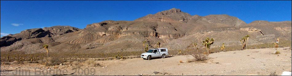
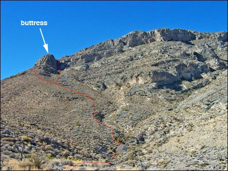
 The route (view W from trailhead) |
Overview This is a moderately strenuous off-trail hike to the top of a limestone mountain with many little limestone cliffs to climb or otherwise get around. Except for little details, the route is straightforward: from the road, the route runs east across washes to the base of the mountain, the follows the eastern and southern ridges to the summit (7,180 ft). The route is fairly short, only about 2 miles, so it makes for a nice desert hike during the short days of winter. Be sure to hike down the way you got up to avoid getting tangled up in dangerous cliffs. Link to a map. For general information on camping, regulations, other issues, and the natural history of the Wildlife Refuge, see the Desert National Wildlife Refuge -- Area Overview page. |
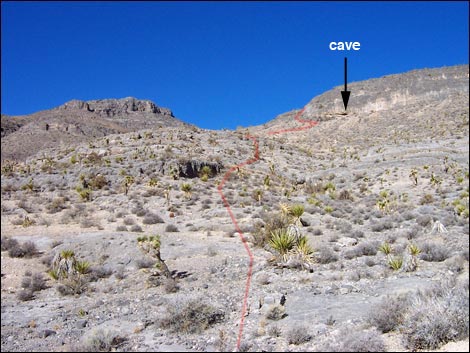 Route stays left of a little cave (view W bottom of the wash) |
Watch Out Other than the standard warnings about hiking in the desert, ...this route has some steep parts and a lot of loose scree. At the top, there is a marginally 3rd-class traverse from the south summit to the north (true) summit. While this is easy, it is a bit airy. There are many limestone cliffs along the route that are difficult to see from above, so go down the same route you went up to avoid getting rimrocked. I tried other routes on my way down and got rimrocked on three of the four routes I tried, twice finding myself in rather precarious positions. The safe thing to do is to hike down the way you got up. During warmer months (i.e., reptile season), be careful climbing the limestone cliffs and watch where you put your hands. While hiking, please respect the land and the other people out there, and try to Leave No Trace of your passage. Also, even though this hike is fairly short, it is remote, so be sure to bring the 10 Essentials. This is a wildlife refuge, so pay extra attention to respecting the land. Don't bother the bighorn sheep; they have a hard enough time making a living in these desert lands. |
 |
Getting to the Trailhead
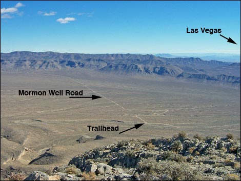
This hike is located on the Desert National Wildlife Refuge, about 1-1/4 hours northwest of town. From town, drive out to Corn Creek Field Station and continue east 50 yards to a T-intersection. Turn right onto Mormon Well Road and drive south and east following the road for 9.0 miles as is bends around to the north and runs up along the east side of the Sheep Range. At a hard curve to the right, turn left into a large, fenced parking area. Park here; this is the Long Canyon Trailhead. |
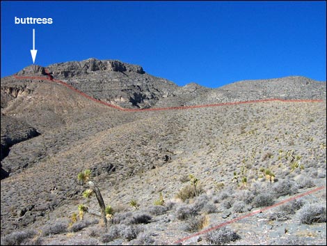
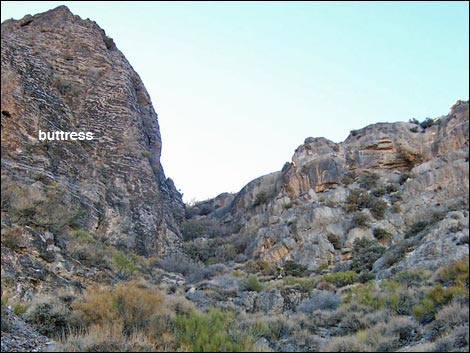
 Route climbs either side of prominent buttress (view SW) |
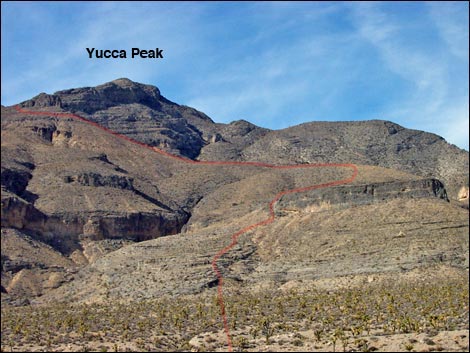
The Hike The trailhead is on the top of a dirt cliff overlooking Long Canyon Wash. From the trailhead (Table 2, Waypoint 1), the route drops into the wash and heads west-northwest across the wash towards the toe of a ridge (Wpt. 2). A small cave (Wpt. 3) on the south end of a band of cliffs makes for a good landmark. It doesn't look like it, but there are several little wash-lets to cross before you get to the base of the mountain, the last of which is the deepest. From the toe of the mountain, the route runs up the ridgeline and scrambles over little limestone ledges, staying south of the cliffs and little cave. The cave is shallower than it looks, so don't bother going over to check it out. This ridge runs west until it crests out and is blocked by a little canyon that can't be seen from below. |
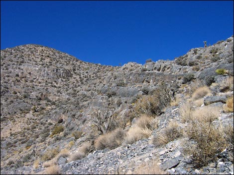
 Steep gully right of prominent buttress (view S) |
On that little ridgetop, the route turns north to run out and around the head of the little canyon, staying on the top of the ridge. The ridge eventually curves to the west, and then back to the south as it works around the canyon. Continuing uphill, the route stays on top of the ridge to the high-point on the ridge (Wpt. 4). The route continues westward for another 10 minutes to another little high-point (Wpt. 5). From the second highpoint, westward progress is blocked by summit cliffs. The route turns south and heads up a scree-filled gully that leads to a gap in the cliffs between the main summit cliffs (to the northwest) and a big, banded buttress on the southeast end of the ridge. The route ascends the scree slope to the base of the buttress (Wpt. 6). From the base of the buttress, hikers can choose the gully (shorter) or side slopes (safer). The gully is steep, brushy, and has a lot of loose rock. The side slopes loop out around the east side of the buttress on a fairly open, but steep scree slopes. |
 |
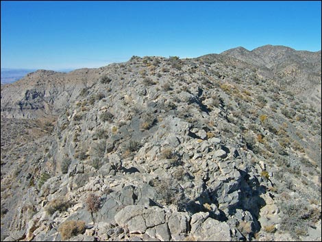
One way or the other, the route climbs to the saddle between the buttress and the rest of the summit cliffs (Wpt. 7). Going up, it took me 12 minutes to climb the gully. If you climb the gully, be careful not to knock rocks on people below you. From the saddle, the route runs up the south side of the summit ridge, staying as high as possible under the cliffs until it is possible to work back onto the top of the summit ridge (Wpt. 8). Following the summit ridge westward to the peak, hikers first arrive on the south summit (Wpt. 9), which has great views (especially towards Las Vegas to the south), and then traverse the short, but airy, 3rd-class ridge to the true summit (Wpt. 10). |
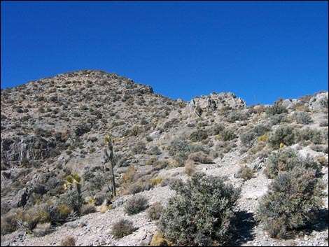 Easy run up S side of summit ridge (view NW) |
Like so many other peaks in this limestone country, the summit is a narrow rocky ridge that provides good views in all directions. To the south are Fossil Ridge, Gass Peak, and the western side of the Las Vegas Valley. To the west are the Spring Mountains. To the north is the spine of the Sheep Range and a great view down into the Long Canyon narrows. To the east are the Yucca Forest and the mountain ranges beyond. To get back to the trailhead, retrace your steps. Don't try to go down the north ridge unless you have previously found a way up that side. I didn't find a route down that side that I was willing to downclimb sight unseen and alone. Back at the saddle between the summit cliffs and the buttress, you might choose to go down by circling around the buttress to avoid down-climbing the gully. It is pretty easy going down the loose scree around the buttress. |
 True summit (view NW from the south summit) |
 Summit (view ESE) |
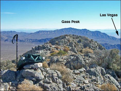 Summit (view SE towards Gass Peak) |
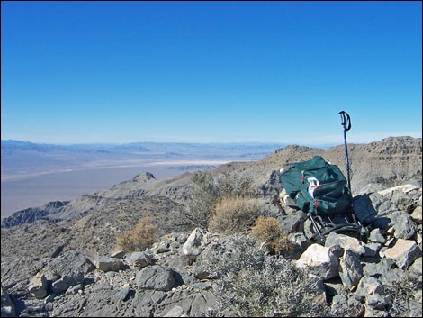
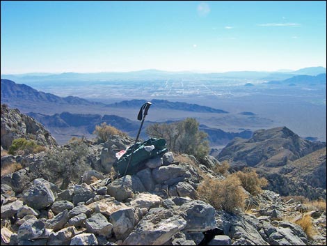 Las Vegas (view S from summit) |
 Summit (view NW to Indian Springs) |
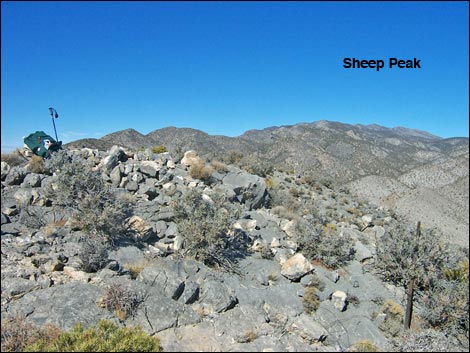 Summit (view N to Sheep Peak) |
Table 1. Hiking Coordinates Based on GPS Data (NAD27, UTM Zone 11S). Download Hiking GPS Waypoints (*.gpx) file.
| Wpt. | Location | UTM Easting | UTM Northing | Elevation (ft) | Point-to-Point Distance (mi) | Cumulative Distance (mi) | Verified |
|---|---|---|---|---|---|---|---|
| 01 | Yucca Peak Trailhead | 658342 | 4038079 | 5,003 | 0.00 | 0.00 | GPS |
| 02 | Toe of Ridge | 657823 | 4038318 | 5,033 | 0.36 | 0.36 | GPS |
| 03 | Small Cave | 657585 | 4038487 | 5,251 | 0.23 | 0.59 | GPS |
| 04 | 1st Highpoint on Ridge | 657087 | 4038805 | 5,691 | 0.50 | 1.09 | GPS |
| 05 | 2nd Highpoint on Ridge | 656925 | 4038871 | 5,897 | 0.16 | 1.25 | GPS |
| 06 | Base of Buttress | 656505 | 4038539 | 6,336 | 0.40 | 1.65 | GPS |
| 07 | Saddle on Summit Ridge | 656444 | 4038524 | 6,558 | 0.06 | 1.71 | GPS |
| 08 | Top of the Ridge | 656362 | 4038708 | 6,743 | 0.17 | 1.88 | GPS |
| 09 | South Summit | 656112 | 4038807 | 7,066 | 0.20 | 2.08 | GPS |
| 10 | True Summit | 656071 | 4038873 | 7,084 | 0.06 | 2.14 | GPS |
| 01 | Yucca Peak Trailhead | 658342 | 4038079 | 5,003 | 2.14 | 4.28 | GPS |
Happy Hiking! All distances, elevations, and other facts are approximate.
![]() ; Last updated 240324
; Last updated 240324
| Hiking Around DNWR | Hiking Around Las Vegas | Glossary | Copyright, Conditions, Disclaimer | Home |