Hiking Around Las Vegas, Death Valley National Park, Argus Range Wilderness Area
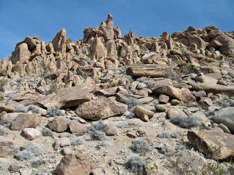
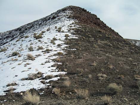
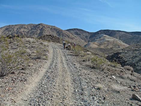 Hiking up road on the steep, narrow ridge (view E) |
Overview This is a great hike in a geologically and historically interesting area that runs up into the edge of the Argus Range Wilderness Area. The access road is rough beyond the turnoff to Darwin Falls (a 4WD vehicle is best), but it traverses historic mining areas that invite exploration on the way to the trailhead. There are a number of variations on the hike, but the more interesting route ascends old mining roads that date from the 1980s and passes between granitic hills and a white carbonate ridge, then climbs to a miner's trail and follows it across volcanic slopes to a saddle between the granitic and volcanic summits. Neither summit has a trail. The descent follows the miner's trail all the way back to a road and the trailhead. Link to map or elevation profile. |
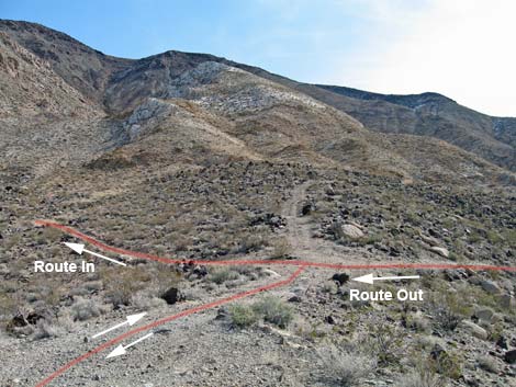 Three-Forks (view E) |
Watch Out Other than the standard warnings about hiking in the desert, ... this hike is fairly safe. There are holes in the ground, which are always interesting but never safe to enter, and some places along the miner's trail are exposed with a long slide down the rubble to the bottom of you slip off the trail. While hiking, please respect the land and the other people out there, and try to Leave No Trace of your passage. Also, this hike is wild and remote, so be sure to bring the 10 Essentials. |
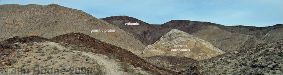
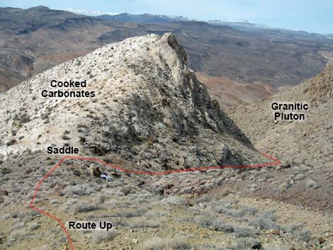
 Route in wash between granitic pluton (left) and cooked carbonates (right and ahead; view E) |
Getting to the Trailhead This hike is located on the far side of Death Valley National Park, about 4 hours northwest of Las Vegas. Technically, the summit is just outside the park boundary. From town, drive out to Death Valley. From the Furnace Creek Visitor Center (Table 1, Site 0712), drive north and west on Highway 190 for about 55 miles to Panamint Springs. Continue west on Hwy 190 for 1.0 miles to Darwin Canyon Road (Site 0977). Turn left onto Darwin Canyon Road and drive south for 5.3 miles on the rough and winding road, passing the parking area for Darwin Falls (Site 0978) and an historic mine area along the way. The road passes a high point on a ridge, winds steeply down into a large wash, and then bends sharply to the right (northwest). When the road hits the wash, an abandoned road forks off to the left (east) and climbs a steep, narrow ridge. Park in the wash; this is the trailhead (Site 0766). |
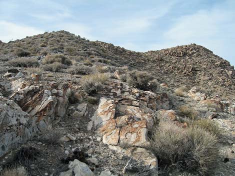
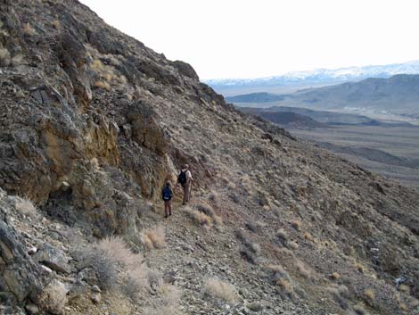
 Coarse-grained granitic hillside (view N) |
The Hike From the trailhead (Table 2, Waypoint 01), the route choices begin... For the more interesting route, drive or hike up the abandoned road to the east as it runs up a steep, narrow ridge. The road gets rough when it crosses a black volcanic area about a half-mile out, but it should be passable in a 4WD vehicle (there are few places to safely turn around on the narrow ridge). Follow this road to a point where it forks into three roads (Three-Forks; Wpt. 2). |
 Looking back from the miner's trail at the white saddle (Wpt. 5) and the route up the north side of the white carbonate hill (view W) |
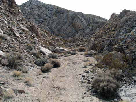
Continuing the more interesting route, follow the northern road (left) as it climbs into a wash between granitic cliffs to the north and white carbonate rocks to the south. This road and wash run up the interface of a granitic pluton (magma that pushed up but did not break the surface of the earth and cooled slowly) and carbonate rocks (limestone or dolomite) that were pushed aside and partially cooked by the heat of the rising pluton. It is quite amazing to hike along the interface of these geologic features. At the major fork in the wash near the top of the white carbonate rocks (Wpt. 3), the road bends to the north and runs up a short way to a shallow mine (adit). At the bend, leave the road and hike off-trail up the south fork of the wash following the edge of the white carbonate rocks to a saddle (Wpt. 4) between the white rocks and the high volcanic ridge to the east. |
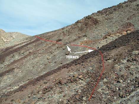 Hiker on miner's trail traversing volcanic scree slopes and nearing saddle on summit ridge (view NE) |
From the saddle (Wpt. 4), hike straight up the red-and-black volcanic hillside to a miner's trail (Wpt. 5) that cuts across the hillside about 60-vertical-feet above the saddle. This old miner's trail cuts steeply up and across scree slopes on the volcanic hillside. The forces of erosion are slowly covering the trail with scree falling from above, but the trail is still easy to follow. The miner's trail runs up and crosses the summit ridge at a saddle (Wpt. 6), then continues over the other side and down to mines that can be seen far below. The saddle sits at the interface of granitic rock and volcanic rock, resulting in a volcanic summit (Wpt. 7) and a granitic summit (Wpt. 10). The volcanic summit is 87 feet higher than the granitic summit, but both summits are worth climbing because of the differing views and to experience the jumbled geology. There is a large cairn on volcanic summit (the true summit) adorned with an old miner's pick, but there is no summit register. Unfortunately, people have damaged the environment by carving their names on rocks near the summit. |
 Granitic summit (view N from saddle on summit ridge) |
After climbing both summits, descend the miner's trail, passing the point where the route intersected the trail (Wpt. 5) and continuing down the miner's trail. After passing switchbacks, the trail passes an old camp area (Wpt. 8). There are rock sleeping shelters here, as well as old cans, broken bottles, and other junk. There are also two rock rings, like large fire rings, that are piled high with dirt. There is no firewood in the area, so the purpose of the dirt-filled rock rings is a mystery to me. Below the old campsite, it appears that the trail runs down a gully, but it stays higher on the ridgeline and continues descending to the west. The trail is then easy to follow until about 50 yards before intersecting an old mining road (Wpt. 9). The trail junction at the road is marked with a fair-sized cairn, and this is also the highest point on the road in this area. |
 Volcanic summit (view S from saddle on summit ridge) |
At the road, turn right (east towards the summit) and walk down the road to cross a large wash (comes down the south side of the white carbonate rocks). Continue on the road a few more minutes to reach the Three-Forks road intersection (Wpt. 2). This closes the loop, so follow the road back down to the trailhead. An alternate, but less interesting route to the summit, is taking the right fork at Three-Forks (Wpt. 2) and walking directly to the bottom of the miner's trail (Wpt. 9), then following the miner's trail all the way to the saddle on the summit ridge (Wpt. 6). This route misses the interface of the granitic pluton and the cooked carbonate rocks. Another alternate, but less interesting route to the summit, is walking up the wash that runs south from the trailhead (Wpt. 1). When the wash crosses an old road, follow the road uphill (east) to the highpoint on the road and the cairn that marks the end of the miner's trail (Wpt. 9). Then follow the miner's trail to the saddle on the summit ridge (Wpt. 6). This route misses the interface of the granitic pluton and the cooked carbonate rocks, as well as the views of the cooked carbonates from the west. |
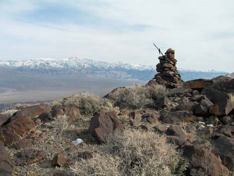 Cairn on volcanic summit (true summit). The stick in the top of the summit cairn is an old miner's pick |
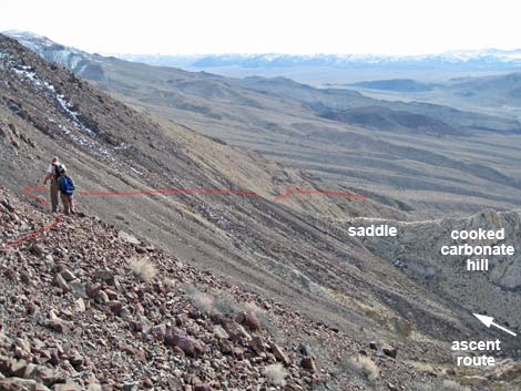 Hikers descending mining trail (view SW). Saddle, cooked carbonates, and route are visible. |
 Hikers passing colorful cliffs while descending the miner's trail (view SW) |
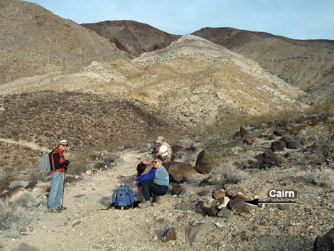 Hikers on old road by cairn marking end of miner's trail. The road leads to Three-Forks (just off photo), and then back to the trailhead. |
Table 1. Highway Coordinates Based on GPS Data (NAD27; UTM Zone 11S). Download Highway GPS Waypoints (*.gpx) file.
| Site # | Location | Latitude (N) | Longitude (W) | Easting | Northing | Elevation (ft) | Verified |
|---|---|---|---|---|---|---|---|
| 0712 | Furnace Creek Visitor Center | 36.46159 | 116.86574 | 512030 | 4034954 | -186 | Yes |
| 0766 | Zinc Hill Parking | 36.29672 | 117.51731 | 453550 | 4016783 | 3,683 | GPS |
| 0977 | Hwy 190 at Darwin Canyon Rd | 36.34005 | 117.47924 | 456992 | 4021571 | 2,100 | GPS |
| 0978 | Darwin Canyon Rd at Darwin Falls Rd | 36.32805 | 117.51352 | 453909 | 4020256 | 2,543 | GPS |
Table 2. Hiking Coordinates Based on GPS Data (NAD27; UTM Zone 11S). Download Hiking GPS Waypoints (*.gpx) file.
| Wpt. | Location | Easting | Northing | Elevation (ft) | Point-to-Point Distance (mi) | Cumulative Distance (mi) | Verified |
|---|---|---|---|---|---|---|---|
| 01 | Trailhead | 453550 | 4016783 | 3,668 | 0.00 | 0.00 | GPS |
| 02 | Three-Forks | 454494 | 4016600 | 4,212 | 0.82 | 0.82 | GPS |
| 03 | Leave road and climb gully | 455038 | 4016606 | 4,626 | 0.46 | 1.28 | GPS |
| 04 | White Saddle | 455131 | 4016418 | 4,817 | 0.16 | 1.44 | GPS |
| 05 | Miner's Trail | 455182 | 4016400 | 4,882 | 0.03 | 1.47 | GPS |
| 06 | Saddle | 455381 | 4016978 | 5,342 | 0.44 | 1.91 | GPS |
| 07 | Summit (volcanic) | 455583 | 4016728 | 5,585 | 0.21 | 2.12 | GPS |
| 10 | False Summit (granitic) | 455312 | 4017237 | 5,498 | 0.22 | . | GPS |
| 08 | Old Campsite | 454850 | 4016182 | 4,529 | 0.99 | 3.11 | GPS |
| 09 | Cairn at Road | 454408 | 4016449 | 4,210 | 0.35 | 3.46 | GPS |
| 02 | 3-Forks | 454494 | 4016600 | 4,212 | 0.15 | 3.61 | GPS |
| 01 | Trailhead | 453550 | 4016783 | 3,668 | 0.82 | 4.43 | GPS |
Happy Hiking! All distances, elevations, and other facts are approximate.
![]() ; Last updated 240324
; Last updated 240324
| Death Valley | Hiking Around Las Vegas | Glossary | Copyright, Conditions, Disclaimer | Home |