Hiking Around Las Vegas, Death Valley National Park
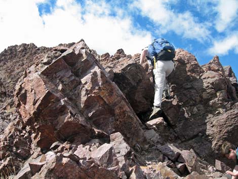
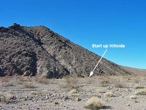 Start of use-trail (view NW from paved road) |
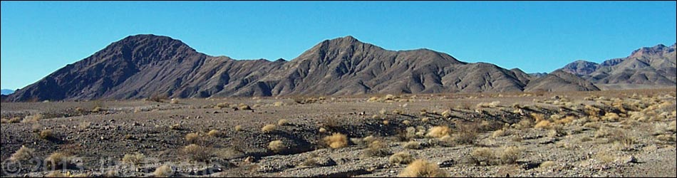
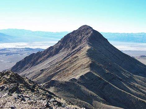
Overview This very strenuous, 1.5-mile dancing-with-the-wind route runs out an open, airy, rocky, and exposed ridge to a summit with truly spectacular views out across the Death Valley Wilderness Area. The steep use-trail climbs 0.75 miles to the lower summit, drops into a saddle, and runs up the ridge and among summit cliffs for another 0.75 miles to the true summit. Gaining the summit requires climbing among 4th-class boulders, traversing a wonderful knife-edge ridge, and crossing a 6-inch-wide ledge with a few hundred feet of exposure. Summit views are truly spectacular, although views from the first knob on the ridge are nearly as good as those from all but the main summit. An alternate start runs around the north side of the ridge, then climbs to the saddle beyond the first summit. This route is tough, but it is among the best I've done in the Mojave Desert. Link to map or elevation profile. |
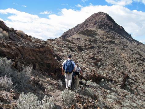
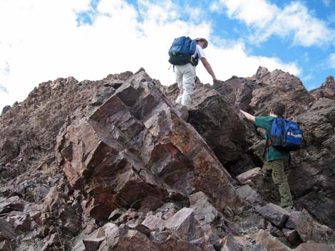
 Approaching 1st saddle (view W from Sunset Knob) |
Watch Out Other than the standard warnings about hiking in the desert, ...this is a steep, exposed ridge with many places where a fall would prove nearly or completely fatal. Stay off this route if it is very windy or if thunderstorms threaten. This route requires 3rd- and 4th-class scrambling. This is not a good route for young children or hikers who fear heights. Historically there has been an anomaly in this area for digital maps such that those maps don't display GPS coordinates correctly. Paper USGS topo maps are OK, but rely on your own instincts, route finding, and map reading skills here if there seems to be a problem; don't put too much weight on the technology. |
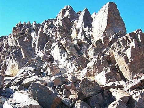
 First summit (view W) |
While hiking, please respect the land and the other people out there, and try to Leave No Trace of your passage. Also, this hike is tough, so be sure to bring the 10 Essentials. This hike goes into the Death Valley Wilderness Area, so pay particular attention to respecting the land. Getting to the Trailhead This hike is located in Death Valley National Park, about 2.5 hours northwest of Las Vegas. |
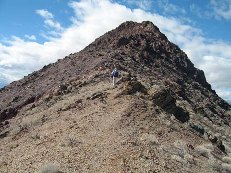
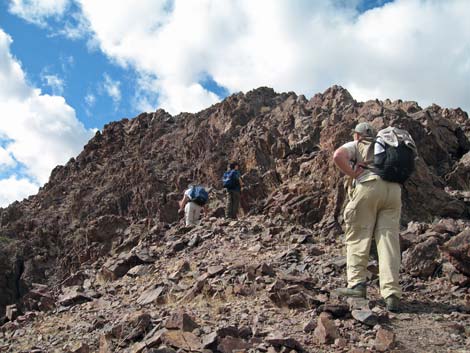
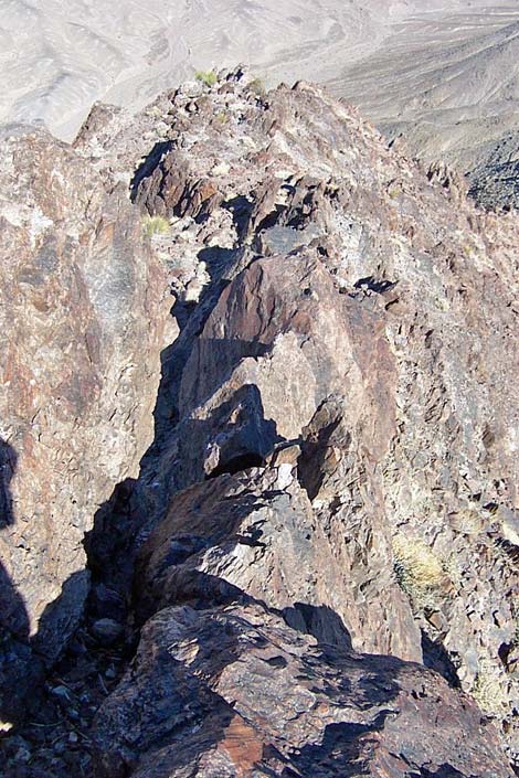
 Route to summit follows ridge (view W) |
From town, drive out to Death Valley. From the Furnace Creek Visitor Center (Table 1, Site 712), drive north on Highway 190 for 10.6 miles to the Beatty Cutoff (Site 742). Turn northeast (right) towards Beatty, and drive for 9.9 miles to the Hell's Gate parking area (Site 769), which is at the Y-intersection with the Daylight Pass Road (Hwy 374). The Rangers recommend parking at Hell's Gate, but it might be easier to turn west (left) at the Y-intersection, drive downhill for 0.5 miles, and park on the side of the road near the base of the Death Valley Buttes ridge (Site 770). Either way, it would be safer to stop at the Hell's Gate parking area, gear up (e.g., put on your boots, get your gear and water ready), and then drive to the toe of the ridge, park, and quickly move off the road. Park on the shoulder of the road, not in the bushes. |
 Hikers beyond the saddle (view W) |
The Hike From the trailhead at Hell's Gate (Table 1, Site 769) or from the side of the road (Table 2, Wpt. 01), you can see a very steep use-trail starting at the toe of the Death Valley Buttes ridge and cutting up and across the northeast side of the ridge (angling up and northwest). This is the start of the use-trail. From either trailhead, hike across the washes to toe of the ridge (Wpt. 02), which is about 3 minutes from the road. The sparse vegetation in the wash is dominated by creosote bush and white bursage, with some buckwheat, cholla cactus, and Beavertail cactus -- not much grows on these hot, dry alluvial deposits. |
 |
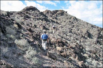
From the toe of the ridge (Wpt. 02), the use-trail runs steeply up the side of the ridge. The ridge appears to be metamorphic rock, looking a bit like granite in color and texture, with a heavy desert varnish that makes the rocks look black. The use-trail runs in loose gravel around rocky outcrops, and stirring up the black surface reveals a light-colored subsurface. The contrast between the light use-trail and the dark ground makes it easy to see the use-trail from as far away as Hell's Gate. Despite the loose gravel, this part of the use-trail is surprisingly firm. |
 |
The steep use-trail quickly leads to a little saddle (Wpt. 03). It is quite a hike up the hillside, but the view down Death Valley to the south is spectacular. The little knob, just east of the saddle, would be a nice place to watch the sunset. By far, the hardest part of the route is getting to the first saddle and a short section just above the saddle. Getting to the saddle is steep with lots of loose rock and gravel, but people have bashed footsteps into the hillside, so it isn't too bad. Just above the saddle, there is a short section where the use-trail runs up and across sloping, gravel-covered rocky slabs with loose gravel. This part of the hike has the worst footing of the entire route and is the only place where I was concerned about slipping and getting hurt. |
 |
From the first little saddle (Wpt. 03), the use-trail runs up and across a steep, south-facing slope to another small saddle, then crosses onto the north-facing slope and heads up to another saddle. It then switches back onto a south facing slope and runs more or less straight up a side-ridge, zigzagging through some loose gravel. Again, the walking is surprisingly easy because steps have been pounded into the slope. Near the top of this slope, the use-trail seems to disappear, but a faint use-trail angles north across the slope and picks up a wide use-trail that looks like the express route down. Take this route up, but on the way down, remember to cut off here. |
 |
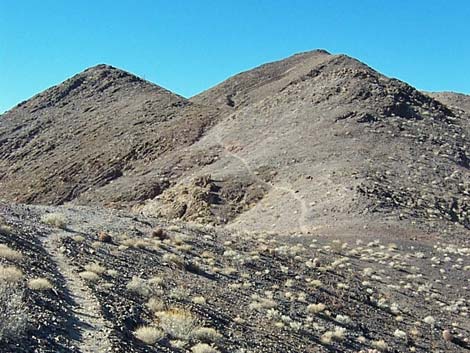
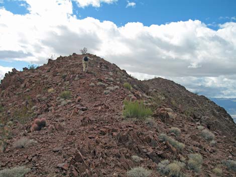
Above this slope, there is a little blip on the ridge (Wpt. 04) that looks from below like it might be the first summit. However, from little blip, the use-trail runs directly up the ridge, scrambles over some rocks on the ridgeline, and then cuts over onto a rocky, north-facing slope that is quite steep. You don't want to fall here, but there is some shade during winter when the sun is low on the southern horizon. The first summit (Wpt. 05) is just above the steep north-facing slope. There are great views to the south and west from the first summit, and for view improvement alone, there is little reason to go on to the true summit. Except for a few highway noises, this is a quiet and serene summit. At this elevation, the vegetation is more diverse than below, and in addition to the creosote and bursage, there is desert holly and barrel cactus. |
 |
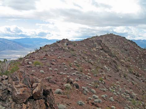
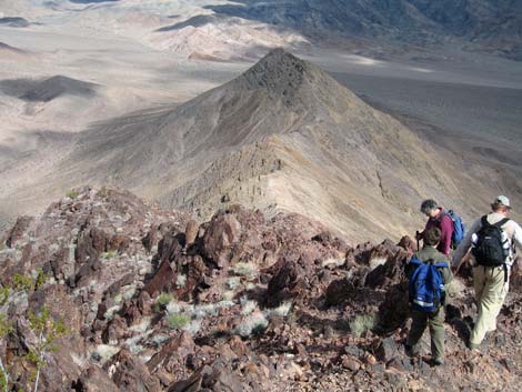
Beyond the first summit, the use-trail continues west, although it is less well defined than before (apparently getting less use). The use-trail runs steeply out and down the crest of the narrow ridge (with nice drop-offs on both sides) before cutting over onto the north-facing slope. The trail material here is as before, loose rocky stuff that is surprisingly easy to walk on. Looking down the steep slope into the saddle, hikers will see a faint use-trail running out of the saddle to the north and down side-ridges that offer an alternate route onto the mountain that bypasses the scenic first summit. The main use-trail runs down to the saddle (Wpt. 06). The alternate route down leaves the main use-trail just past the bottom of the saddle (Wpt. 07). |
 Rocky route through summit cliffs (view W) |
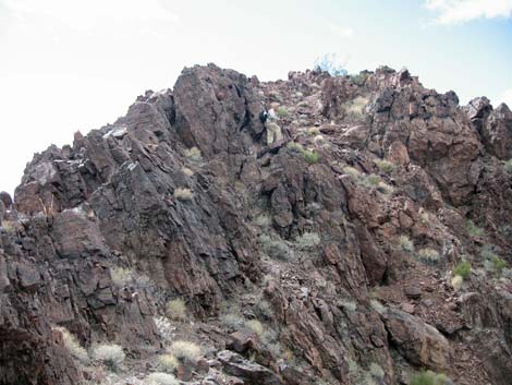
From the main saddle, the use-trail runs along the north side of the ridge at a fairly gentle grade, making for a relatively easy walk up to the next shallow saddle (Wpt. 08). From this saddle, which is right below the summit cliffs, the route runs up into the imposing rocky cliffs. Remember this place on the way down because it would be easy to miss the use-trail as it slips off the side of the ridge (although continuing down the ridge would work). Continuing up the ridge, the base of the summit cliffs, which actually is a steep broken boulder field, is marked by three enormous boulders, two of which look like they should start rolling down the hillside at any time. These improbable boulders can even be seen from the highway below, and they look just as improbable from there. |
 Knife-edge ridge (view E; down) |
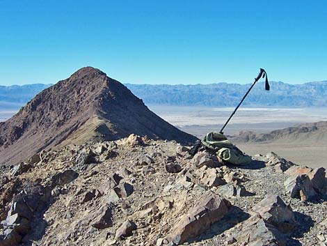
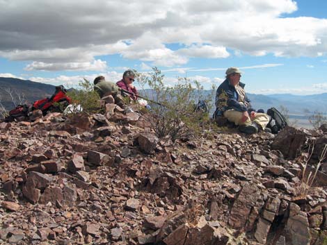
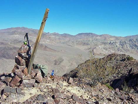
Working up along the summit ridge, you scramble up some 3rd and 4th-class sections, climb a knife-edge ridge, and do some serious dancing with the wind. In one place, the route crosses a ledge that narrows to about 6 inches wide, and if you fell, which you won't, it would your last. There are several use-trails on some parts of the summit ridge, but it seems that the best route stays as close to the crest of the ridge as possible. It seems that people have tried to find routes off of the crest of the ridge, but those routes looked worse than the ridge. After climbing through the summit cliffs, you suddenly crest out on the east edge of the summit, which is also a bit airy. Wander over to the massive summit cairn (Wpt. 09), sit and rest, and enjoy the summit solitude and the views. On clear days you can see the High Sierras to the west. While on the summit, notice that the vegetation is sparse, but there is a fair bit of species diversity compared to the surrounding landscape, and that it includes creosote bush, bursage, Ephedra, buckwheat, and even a pygmy cedar. To get down, follow your tracks back down the ridge. Be sure to stay close to the ridgeline as you get started. Below the summit cliffs, as you pass the improbable boulders and get onto the flat ridgetop, watch for the start of the use-trail as it cuts off onto the north side of the ridge. The start is hard to see, and is a bit hard to follow going down, but after you get out around the edge, you can see ahead to where the use-trail is well defined. |
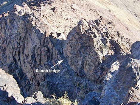 Looking down at the 6-inch ledge (view E) |
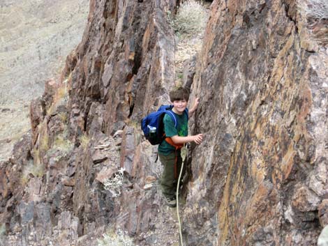 Young Ben on a string traversing 6-inch ledge (view E) |
 Hikers on the last of the cliffs (view SW) |
 Hiker on summit flats (view SW) |
 Hiker on summit flats (view SW) |
 Hikers on the summit |
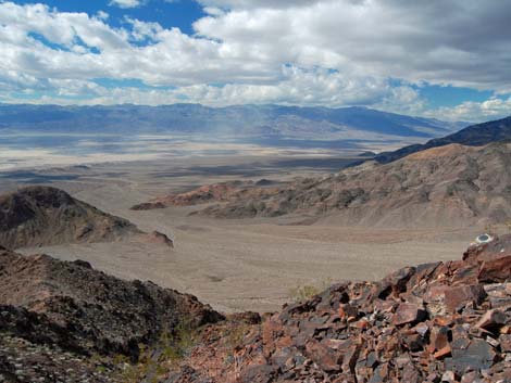
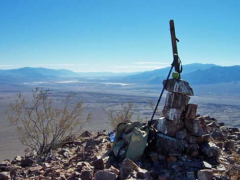 Summit (view S down Death Valley) |
 Summit (view NE into the mountains) |
 Summit (view NW) |
 Hikers departing the summit (view E) |
Table 1. Highway Coordinates (NAD27; UTM Zone 11S). Download Highway GPS Waypoints (*.gpx) file.
| Site | Location | Latitude (N) | Longitude (W) | Easting | Northing | Elevation (ft) | Verified |
|---|---|---|---|---|---|---|---|
| 0712 | Furnace Creek Visitor Center | 36.46159 | 116.86574 | 512030 | 4034954 | -186 | Yes |
| 0742 | Hwy 190 at Beatty Cutoff | 36.58805 | 116.94240 | 505153 | 4048974 | -190 | Yes-2 |
| 0769 | Daylight Pass Rd at Beatty Cutoff (Hell's Gate) | 36.72392 | 116.97718 | 502038 | 4064044 | 2,289 | Yes |
| 0770 | Daylight Pass Rd at DEVA Buttes Parking | 36.71764 | 116.97931 | 501848 | 4063348 | 2,106 | Yes |
Table 2. Hiking Coordinates Based on GPS Data (NAD27; UTM Zone 11S). Download Hiking GPS Waypoints (*.gpx) file.
| Wpt. | Location | Easting | Northing | Elevation (ft) | Point-to-Point Distance (mi) | Cumulative Distance (mi) | Verified |
|---|---|---|---|---|---|---|---|
| 01 | Trailhead | 501849 | 4063349 | 2,106 | 0.00 | 0.00 | Yes |
| 02 | Toe of Ridge | 501602 | 4063349 | 2,086 | 0.15 | 0.15 | GPS |
| 03 | First little saddle | 501438 | 4063301 | 2,228 | 0.12 | 0.27 | GPS |
| 04 | Little blip on ridge | 501061 | 4063189 | 2,540 | 0.26 | 0.53 | GPS |
| 05 | First summit | 500733 | 4063121 | 2,758 | 0.20 | 0.73 | GPS |
| 06 | Main saddle | 500543 | 4062990 | 2,520 | 0.15 | 0.88 | GPS |
| 07 | Alternate route down | 500480 | 4063004 | 2,492 | 0.04 | 0.92 | GPS |
| 08 | Another saddle | 500107 | 4062872 | 2,617 | 0.26 | 1.18 | GPS |
| 09 | Main Summit | 499669 | 4062677 | 3,030 | 0.31 | 1.49 | GPS |
| 10 | Alternate route, Base of Gully | 500373 | 4063445 | 2,076 | . | . | GPS |
Happy Hiking! All distances, elevations, and other facts are approximate.
![]() ; Last updated 240324
; Last updated 240324
| Death Valley | Hiking Around Las Vegas | Glossary | Copyright, Conditions, Disclaimer | Home |