Rock Art Around Las Vegas
Rock art is a precious resource. Please help protect and preserve these sites.
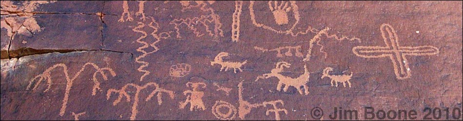
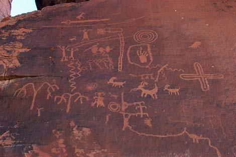
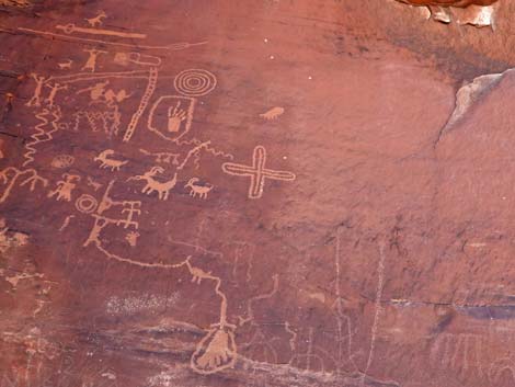
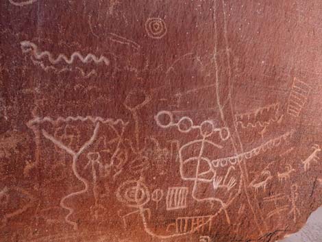
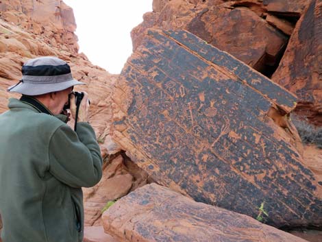
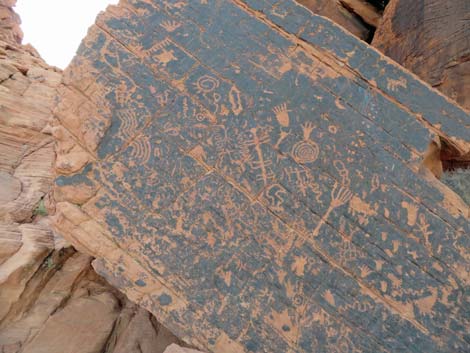
 Main Atlatl Rock petroglyph panel (view NW) |
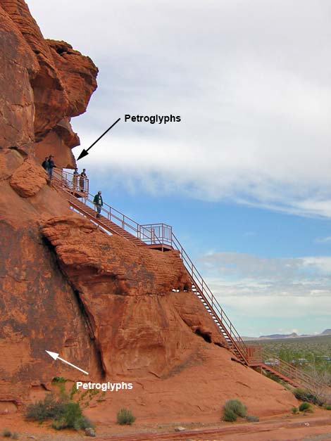
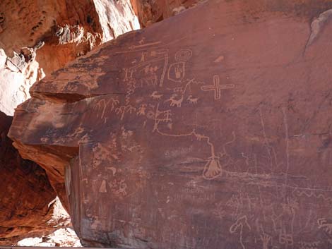
Description The Valley of Fire is a dry, sparsely vegetated desert area with spectacular red sandstone crags and rock piles that have eroded in a variety of interesting and unusual forms. Many rock faces are covered with desert varnish, a naturally occurring dark patina that forms on the surface of rocks in the desert. Native peoples who lived in the area created petroglyphs by pecking away the desert varnish to reveal the underlying light-colored sandstone rock. Access is via paved roads. The main road runs east-west across the State Park through a broad, flat valley bordered by dark gray limestone mountains on the south and fire-red sandstone crags on the north. The campground and Atlatl Rock are in the western end of the valley, the Visitor Center is in the center, and Lake Mead lies just beyond the eastern end. One side-road, starting at the Visitor Center, runs north through a red sandstone canyon and out into a spectacular area with multicolored (shades of red and white) sandstone crags. Atlatl Rock is a single, large boulder perched precariously atop a sandstone outcrop. The State Park has installed metal stairs that can be used to climb up and see the petroglyphs on the smooth east face of Atlatl Rock. Most people climb the stairs, look at the petroglyph display, and leave. Unfortunately, they miss most of the rock art. From the Atlatl Rock parking area, the stairs are ahead and to the left. If you continue walking along the base of the rock past the stairs, you will find many petroglyphs, including a spectacular boulder, the front face of which is completely covered in petroglyphs. In addition, from the Atlatl Rock parking area, there is a shallow canyon between Atlatl Rock and the next sandstone outcrop to the west (right). There are some nice petroglyphs in the canyon and on the other rock. |
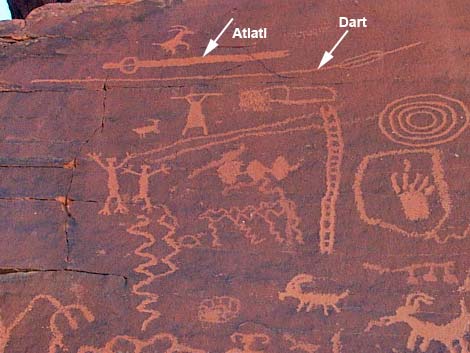 |
These sites are just the tip of the iceberg at Valley of Fire. Wander around and explore the area looking for petroglyphs and other evidence of past human use of the area. Remember, however, petroglyphs and artifacts are national treasures that are easily damaged. Please take care of the area and leave it as you found it for generations to come. By the way, an atlatl or throwing stick, is a tool that was used to throw arrows and spears before the invention of bows. Effectively, an atlatl is an arm extension that enabled the user to throw spears much faster and harder than could be done with the human arm alone. An image of an atlatl is portrayed at the top of the Atlatl Rock Petroglyph panel. |
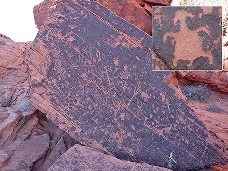
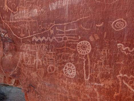
 South side of Atlatl Rock; binoculars are useful (view NW) |
Location Valley of Fire is located about one hour east of Las Vegas. The quickest way to get to the Valley of Fire from Las Vegas is to drive north on Highway I-15 (actually northeast) for about 33 miles to Exit 75E. Exit at the Indian Smoke House and drive east on Highway 169 for about 20 miles. After crossing the mountains and driving down a spectacular limestone canyon, you will arrive at the entrance station and the first views of the red sandstone crags. Pay the fee, and then continue east for 2 miles or so to the campground turnoff (Table 1, Site 0338). Turn left towards the campground, but stay to the right at the campground entrance. The Atlatl Rock parking area (Site 0325) is just beyond the campground entrance. After visiting Atlatl Rock, drive back to the main road and continue east for another 2 miles or so to the Visitor Center (Site 0683). |
 Atlatl Rock (view W) |
Links to Area Map and Site Map. A more scenic, but slower way to get to the Valley of Fire from Las Vegas is to drive out through Lake Mead National Recreation Area. From downtown, drive north on Highway I-15 for about 2 miles to Lake Mead Blvd. Exit the Interstate and drive east Lake Mead Blvd. Cross over the mountains, pass the Lake Mead entrance station (paying $5 per vehicle), and continue to the T-intersection at Northshore Road. Turn left (east) onto Northshore Road and drive out past Echo Bay to the turnoff to Valley of Fire. Turn left (west) and drive about 6 miles to the Visitor Center (Site 683). Pay the entrance fee at the Visitor Center. |
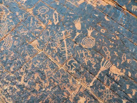
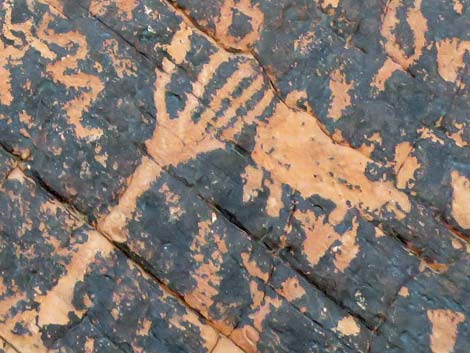
 Boulder on south side of Atlatl Rock. Inset: Horned Lizard? |
Hours The park is always open. The visitor center (open daily, 8:30 AM to 4:30 PM) provides exhibits on the geology, ecology, prehistory, and recent history of the park. Most birding and hiking places are in day-use areas. Fees Entrance Fee: $15.00 per vehicle per day ($10 for Nevada residents). Camping Fees: 20.00 per night per vehicle ($10 entrance fee + $10 more), but you get long hot showers for that price (showers only in Atlatl Rock Campground). Add $5 for non-Nevada campers. For More Information Visit the state park website; or call them at 702.397.2088. |
 |
 |
 |
 |
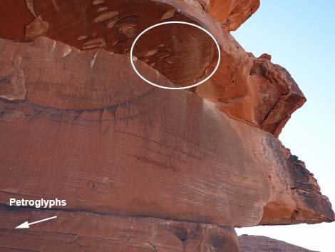 While on the viewing platform, but sure to look up and right |
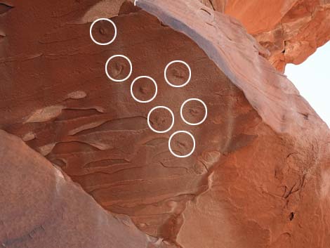 Dinosaur tracks! |
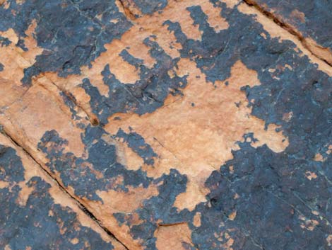
 Boulder on south side of Atlatl Rock |
 Boulder on south side of Atlatl Rock |
 Boulder on south side of Atlatl Rock |
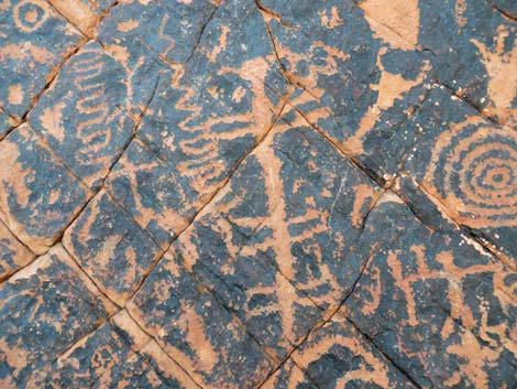 Boulder on south side of Atlatl Rock |
 Tortoise? (boulder on south side of Atlatl Rock) |
 Boulder on south side of Atlatl Rock |
Table 1. Highway Coordinates based on GPS data (NAD27; UTM Zone 11S). Download Highway GPS Waypoints (*.gpx) file.
| Wpt. | Location | Latitude (°N) | Longitude (°W) | UTM Easting | UTM Northing | Elevation (feet) |
|---|---|---|---|---|---|---|
| 0338 | Hwy 169 at Atlatl Turnoff | 36.42147 | 114.54326 | 720261 | 4033300 | 2,247 |
| 0325 | Atlatl Rock Parking | 36.42347 | 114.54954 | 719693 | 4033508 | 2,231 |
| 0683 | Valley of Fire, Visitor Center | 36.43000 | 114.51270 | 722977 | 4034313 | 2,001 |
Happy Hiking! All distances, elevations, and other facts are approximate.
![]() ; Last updated 240323
; Last updated 240323
| Rock Art | Glossary | Copyright, Conditions, Disclaimer | Home |