Rock Art Around Las Vegas
Rock art is a precious resource. Please help protect and preserve these sites.
 Boulder with hand prints (view east from outhouse) |
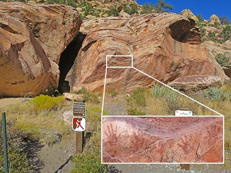
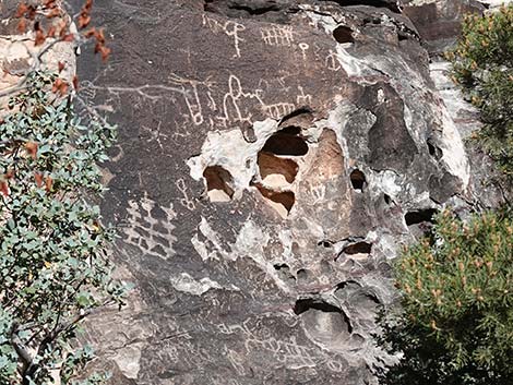
Description Willow Springs is located a deep, shady canyon where the east-west trending La Madre Mountains meet the north-south trending Spring Mountains. Compared to the surrounding desert, Willow Springs Canyon is deep, cool, and moist. Permanent water is available here at two springs: Willow Spring (north end of the picnic area) and Lost Creek Spring (about 0.4 miles south of the picnic area). Water also runs in the wash during winter. It is easy to see why native people spent time in this area. Scattered about the area are boulders and sandstone cliffs. Many rock faces are covered in desert varnish, a naturally occurring dark patina that forms on the surface of rocks in the desert. Native peoples created petroglyphs by pecking away the desert varnish to reveal the underlying red and white sandstone rock. The best examples of petroglyphs here are on a wall across the wash from the picnic area. From a few yards past the end of the pavement, follow the Petroglyph Wall Trail northwest across the wash. |
 Hand Prints (view E) |
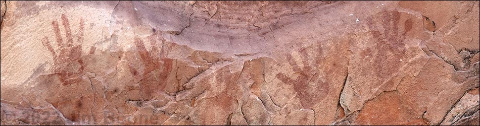
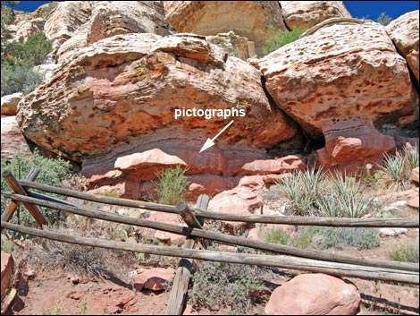
Native peoples also used paint to mark on the rock surfaces (pictographs), the best examples of which are hand paintings high on the underside of an overhanging boulder behind the small outhouse in the picnic area. Here, native peoples put red paint on their hand, then jumped up and slapped the rock, leaving a red imprint of their hand on the rock. There are relatively few pictographs in the area, as most probably deteriorated in the weather, and hand paintings are unusual among pictographs. Please be especially careful with these rather personal messages from the ancients. Another pictograph, a more-typical symbol rather than a hand painting, can be seen on the Willow Springs Loop Trail, two or three minutes north of Lost Creek Spring. Please remember that rock art, and especially pictographs are national treasures that are easily damaged -- take care and leave the area as you found it for generations to come. |
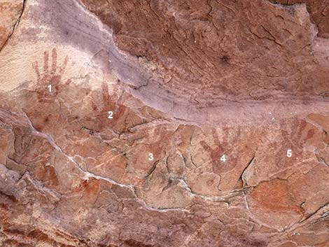 Five Hand Prints |
Native people also made agave-roasting pits in the canyon. An excellent example of which is located adjacent to the hand paintings. Agave-roasting pits are large cooking pits (10 to 45 feet across and up to 10-feet high) used by native peoples and recognized as doughnut-shaped piles of limestone rocks. Native peoples dug a pit, lined it with limestone rocks, and built a big fire in the pit. When the fire burned down to coals, they scraped the coals to the side, put the food (agave and meat) in the hot bottom of the pit, and covered everything with coals and hot limestone rocks from the edge of the pit. When the food was cooked, they uncovered it by scraping the rocks and ash to the side. Apparently, the rocks don't hold the heat after a couple of roastings, so new rocks are constantly added, which results in the large doughnut-shaped piles. More agave-roasting pits can be found along the wash up the canyon. |
 Agave roasting-pit adjacent to Hand Prints (view S) |
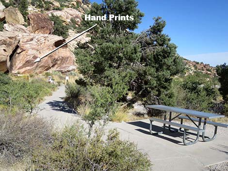
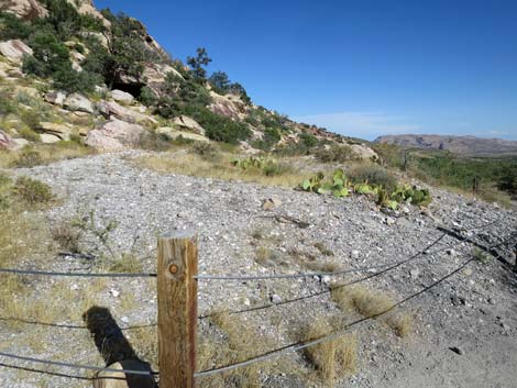
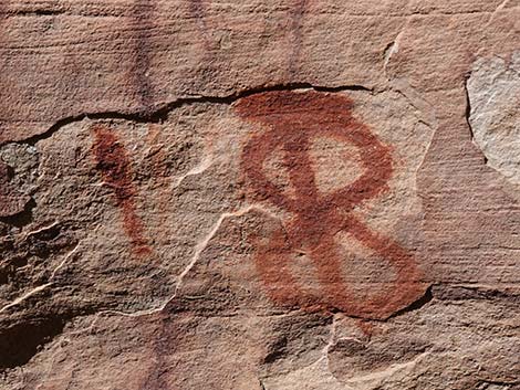
There are some nice petroglyphs on the wall across the canyon. From the end of the pavement, walk across the wash on the Petroglyph Wall Trail. The trail is well-defined; watching for a pole fence that blocks access to the base of the cliffs. The rock art is right just behind the fence. There are also a few pictographs (faint red paintings) to the left of the petroglyphs under an overhang. Access to Willow Springs Canyon is via a good, paved road. Access to the hand paintings and an agave-roasting pit are via a short, paved trail. Access to the petroglyphs is via a short, rocky trail. |
 Pictograph near Lost Creek Spring (view SW) |
Location The area is located along the Scenic Loop Road in Red Rock Canyon National Conservation Area, about 1 hour west of Las Vegas. Links to Area Map and Site Map. From town, drive out to Red Rocks. From West Charleston at Scenic Loop Road (Table 1, Site 519), turn right and drive north for 0.2 miles to the entrance station (Site 855). Pay the fee, then drive around the one-way Scenic Loop Road to Willow Springs Road (Site 526), which is at Mile Marker 7.5 (0.5 miles past Mile Marker 7). Turn right onto Willow Springs Road and drive north for 0.6 miles to the end of the pavement at Willow Springs Picnic Area (Site 181). |
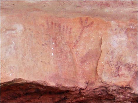 Pictograph near Lost Creek Spring (view SW) |
Hours Red Rocks is a day-use area. The actual opening and closing times change through the year, but generally follow sunrise and sunset. Fees $7 per vehicle. Federal Lands and other passes accepted. |
 Petroglyph Wall petroglyphs (view NW from the road) |
 Petroglyph Wall pictograph (view W) |
Table 1. Highway Coordinates based on GPS data (NAD27; UTM Zone 11S). Download Highway GPS Waypoints (*.gpx) file.
| Site | Location | Latitude (°N) | Longitude (°W) | UTM Easting | UTM Northing | Elevation (feet) | Verified |
|---|---|---|---|---|---|---|---|
| 181 | Willow Springs picnic area | 36.1610 | 115.4980 | 635106 | 4002654 | 4,575 | Yes |
| 519 | Charleston Blvd at Scenic Loop Rd entrance | 36.1318 | 115.4206 | 642120 | 3999525 | 3,681 | Yes |
| 526 | Scenic Loop Rd at Willow Springs Rd | 36.1561 | 115.4891 | 635906 | 4002118 | 4,441 | Yes |
| 855 | Scenic Loop Rd at Entrance Station | 36.1325 | 115.4228 | 641918 | 3999598 | 3,682 | Yes |
Happy Hiking! All distances, elevations, and other facts are approximate.
![]() ; Last updated 240323
; Last updated 240323
| Rock Art | Glossary | Copyright, Conditions, Disclaimer | Home |