Birding Around Las Vegas, Outside the Las Vegas Valley
Ash Meadows National Wildlife Refuge, administered by the U.S. Fish and Wildlife Service, includes 22,117 acres of Mojave Desert with wetlands and more than 30 seeps and springs that, when all sources are considered together, produce more than 10,000 gallons of water per minute. The springs provide water for wetlands, creeks, lakes, mesquite and ash thickets, cottonwood trees, meadows, and salt flats, all of which are surrounded by saltbush flats and Mojave Desert Scrub habitat. These wetlands in the desert support the greatest local-area concentration of endemic species in the US, with 24 species of endemic plants and animals. There are 13 threatened or endangered species on the refuge, including 4 endangered fish and 1 endangered plant. This is also a good place for watching dragonflies.
Top Ash Meadows Birding Sites
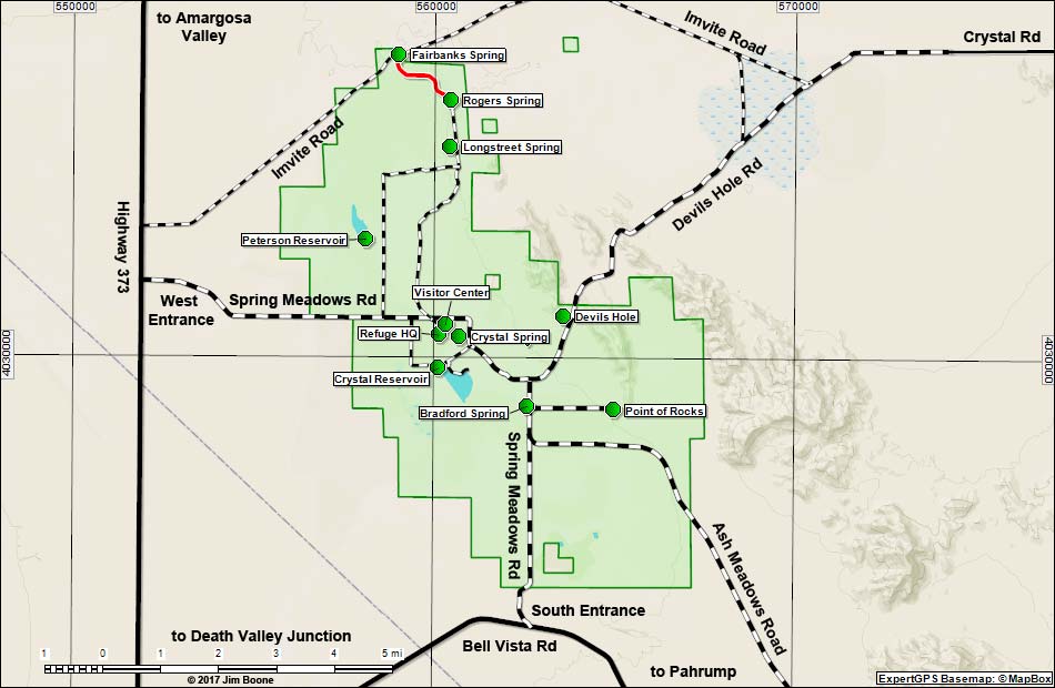
Bradford Spring. A small spring area with lots of trees. This is a place to stop when on the way to other places.
Crystal Reservoir. A remarkably clear, 70-acre reservoir that attracts waterfowl and other water birds, plus provides drinking water for other species. The low dam is a good place to watch birds on the water and in the thickets and marshland below the dam.
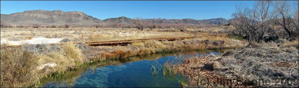
Crystal Spring. A clear, warm-water spring with a spring pool and an outflow stream that runs through fairly open country with scattered mesquite thickets. A boardwalk runs along the outflow stream.
Devils Hole. Water in the bottom of this pit serves as the only habitat for the Devils Hole pupfish. The area is sparsely vegetated with creosote bush and white bursage, and desert birds come here for water.
Fairbanks Spring. A spring pool and marshy area with cattails, sedges, saltgrass, willows, ash and cottonwood trees, mesquite thickets, and forbs.
Longstreet Spring. A spring with a 40-foot diameter pool and a strong outflow. The pool is surrounded by trees and shrubs, all of which is surrounded by dry desert saltbush, a few mesquite, and old farmland off to the west.
Peterson Reservoir. A remarkably clear reservoir held behind a low dam. The reservoir is surrounded by cattails and bulrushes. The dam is good for watching birds on the water and in the marshland below the dam.
King's Pool and Point of Rocks. Several small springs on a hillside feed marshes and mesquite thickets at the base of a hill. King's Pool is a spring pool with outflow; the other springs flow directly into streams. Refuge personnel are revegetating this area.
Rogers Spring. A spring with a 30-foot diameter pool and strong outflow. The pool is surrounded by trees and shrubs, all of which is surrounded by dry desert saltbush, a few mesquite, and old farmland off to the west.
Overview
Ash Meadows National Wildlife Refuge was established in 1984 to prevent intensive farming, grazing, and development from lowering the water table, destroying this unique riparian area, and driving the endemic species to extinction. Much of the refuge area was farmed, and it still shows evidence of this activity, but refuge personnel are working to reclaim the lands and restore the natural habitat.
There are a couple of main habitat types to bird: open-water lakes, marshy springs, and the open country with scattered mesquite thickets. The lakes (e.g., Crystal and Peterson reservoirs) are good for waterfowl, wading birds, gulls, shorebirds, swallows, and the incidental desert species that come in for water. The smaller springs (e.g., Longstreet, Rogers, Fairbanks, and Point of Rocks) have small ponds, streams, trees and shrubs, and cattail-bulrush marshes. These areas can be good for wrens, warblers, flycatchers, and similar upland and marsh species. The more-open country with scattered mesquite thickets (e.g., the Crystal Spring Boardwalk and areas between the springs) is good for shrikes, sparrows, flycatchers, thrashers, swallows, and similar upland species.
There are no stores on the refuge, so bring what you need for the day (e.g., water, food, sunscreen, and hats). The refuge is spread out, so get a map at the Visitor Center or grab one here. Roads on the refuge are graded dirt, so drive carefully, especially during wet weather because they can become flooded and impassable. Do not try to drive north from Devils Hole during wet weather, and if you do drive that way, turn right at a fork about 4.6 miles north of Devils Hole (the main road seems to go left, but you want to go right). The town of Pahrump (22 miles east of the refuge) has all services, and gas and food are available just west of the refuge at Stateline (Nevada Hwy 373 and California Hwy 127).
Except for certain areas, the refuge is open for hunting according to Nevada State laws. Hunting is with shotguns only, so other than noise, hunters should pose little danger for birders.
Location
The Ash Meadows National Wildlife Refuge is located about 2 hours northwest of Las Vegas.
The easiest way to get there from Las Vegas is to drive north on Highway 95 for about 90 miles to Highway 373 at Amargosa Valley (Table 1, Site 0689). Turn left onto Highway 373 and drive south towards Death Valley Junction for 14.5 miles to Spring Meadows Road (Site 690). Watch for Wildlife Refuge signs along the highway. Turn left onto Spring Meadows Road and drive east towards the refuge.
The turnoff is about 2 miles before (north of) the California-Nevada border (15-16 miles from Highway 95). An old open-pit clay mine makes for a good landmark -- the access road is just north of the mine.
Driving east on Spring Meadows Road, visitors enter the wildlife refuge at 3.0 miles out, and arrive at Visitor Center Road at 5.5 miles out. By this point, the Visitor Center (Site 1588) is clearly visible south of the road, and several signs direct visitors into the parking areas. Many of the parking stall are even covered.
For the return trip, drive out of the refuge to the south and make a loop by driving southeast into Pahrump on Bell Vista Avenue, the only paved road south of the refuge (in California, this road is called State Line Road). In Pahrump, take Highway 160 south and over the mountains into the southern end of the Las Vegas Valley.
Hours
The refuge is open from sunrise to sunset. The Visitor Center is open daily, 9 AM to 4:30 PM. Parts of the refuge are closed to entry. Devils Hole is fenced and closed to public entry, and there are some private lands within the boundaries of the refuge (see the official refuge map and always respect private property rights). Snatch a PDF copy of the map here.
Fees
None.
Specialties
Ash Meadows, with a bird list of 239 species, is a good place to watch waterfowl, hawks, migrants, and desert species (lists available at the refuge office and online). The spring (April and May) and fall (mid-August through September) migrations are the best times to bird this refuge to see large numbers of species and individuals, but winter is good for waterfowl. In the desert, any tree is good for finding birds year-round, and trees at the refuge office and Point of Rocks are good places to check for species such as Crissal Thrasher, Verdin, Phainopepla, and Lucy's Warbler.
The area was originally set up to protect several species of endemic fish, so be sure to check the springs and running water for pupfish and speckled dace. Also, be sure to visit Devils Hole, a spring that provides the only habitat on earth for Devils Hole Pupfish. This fish has the smallest geographic range of any vertebrate species. It is a wonder that the species has survived for thousands of years in this tiny hole.
The refuge provides habitat for some 239 species of birds, 27 species of mammals, 5 amphibians, 20 reptiles, and 7 fish. The mammals are mostly nocturnal, but watch for coyotes, black-tail jackrabbits, desert cottontails, and white-tailed antelope squirrels during the day. The reptiles are mostly nocturnal too, but watch for them during the spring and fall. Amphibians are most active after spring and summer rains. Snakes are rarely seen, but coachwhips and gopher snakes are fairly common; rattlesnakes are not common. Native pupfish can be seen in most of the springs, and the Devil's Hole pupfish occurs naturally only within Devil's Hole. The best place to see the endangered Ash Meadows pupfish is in King's Pool at Point of Rocks. Dace occur in the Bradford and Jackrabbit springs and outflows.
The Crystal Spring boardwalk trail is a good place to bird and to see some of the threatened plants (e.g., spring-loving centaury, Ash Meadows gumplant, and ivesia) and other interesting plants that require moist soils and can tolerate salty soils.
For More Information
Stop at the Visitor Center, visit the refuge website, or contact the Refuge Manager by mail: Refuge Manager; Ash Meadows National Wildlife Refuge; HCR 70, Box 610-Z; Amargosa Valley, NV 89020; (775) 372-5435.
Table 1. GPS Coordinates for Highway Locations (NAD27; UTM Zone 11S). Download Highway GPS Waypoints (*.gpx) file.
| Site # | Location | Latitude (°N) | Longitude (°W) | UTM Easting | UTM Northing | Elevation (feet) | Verified |
|---|---|---|---|---|---|---|---|
| 0689 | Highway 95 at Highway 373 | 36.6439 | 116.3995 | 553676 | 4055332 | 2,660 | Yes |
| 0690 | Highway 373 at turn off to Ash Meadows | 36.4346 | 116.4212 | 551884 | 4032106 | 2,195 | Yes |
| 1588 | Ash Meadows Visitor Center | 36.42323 | 116.32703 | 560329 | 4030901 | 2,188 | GPS |
Happy birding! All distances, elevations, and other facts are approximate.
![]() ; Last updated 170630
; Last updated 170630
| Birding Around Las Vegas | Southern Nevada Birds | Guide Service | Copyright,Conditions, Disclaimer | Home |