Hiking Around Las Vegas, Lake Mead National Recreation Area
 Callville Wash North Road trailhead parking (view N) |
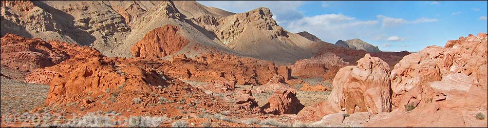
Overview The Bowl of Fire is an area inside the Muddy Mountains Wilderness Area where brilliant-red Jurassic-Age sandstone outcrops are surrounded by gray limestone mountains. The limestone forms the sides of the bowl, and the red sandstone forms the fire in the bottom. The southwestern section of the Bowl of Fire is a place to wander about in a wonderland of jumbled piles of red sandstone. There are two trailheads: a 2WD trailhead and a 4WD trailhead. Described here is the start of the route using the 4WD trailhead. See the description of the route from the 2WD trailhead for a complete description of the route. Link to map. |
 4WD trailhead in Callville Wash (view NW) |
Watch Out Other than the standard warnings about hiking in the desert, ...this is fairly safe hiking area if you stay in the bottom of the washes that dissect the sandstone outcrops. The outcrops are inviting, however; so if you climb on the rocks, watch your step and watch your kids. This is a backcountry area, so rescue would be time consuming and fairly difficult. It would be easy to get turned around in the maze of side canyons and boulder piles, so if you get "lost," just hike down any wash (always go downhill) and you will come out were you went in. While hiking, please respect the land and the other people out there, and try to Leave No Trace of your passage. Also, this hike is moderately long, so be sure to bring the 10 Essentials. This hike goes into the Muddy Mountains Wilderness Area, so pay particular attention to respecting the land. |
 Callville Wash North Road trailhead (view N) |
Getting to the Trailhead This hike is located along Northshore Road in Lake Mead National Recreation Area, about 45 minutes northeast of Las Vegas. From town, drive out to Lake Mead. In a 2WD vehicle, drive north on Northshore Road to Mile 18.2 Trailhead. Park here; this is the 2WD trailhead. In a 4WD vehicle, drive north on Northshore Road to the Mile 16.0 (Anniversary) Trailhead. Turn left into the dirt and drive up Callville Wash North Road (Road 94) for about 1.8 miles to the mouth of a large wash (Bowl of Fire Wash) that comes in from the left (Site 0786). Park here; this is the Bowl of Fire 4WD trailhead parking. |
 Wilderness Area boundary sign at trailhead (view N) |
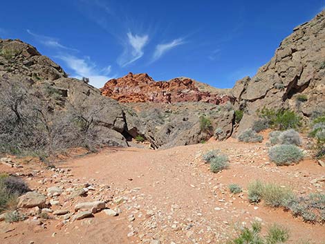
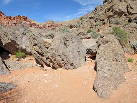
The Hike From the 4WD Trailhead (Table 1, Waypoint 02a), the hike simply runs up Bowl of Fire Wash. Initially, the wash is wide and open, and shortly the canyon narrows at a place where the wash cuts through a layer of green mudstone (volcanic ash). Red sand, washing out of the Bowl of Fire, lies over the green rocks, providing an interesting mix of gray, green, and red colors. Continuing upstream, the wash eventually narrows and deepens as it approaches a narrow point between two limestone hills. At the lowest spot (Wpt. 05), the wash cuts through a narrow slot in the layer of gray conglomerate rock, and a jumble of boulders creates a small pour-over. The routes from the two trailheads have now merged. For a description of the remainder of the route, see Bowl of Fire - Southwest. |
 BOF SW Wash (view N) |
 Bowl of Fire Wash (view N) |
 Outcrop of green mudstone (view NW) |
 Green mudstone, red sand, and bunchgrasses |
 Green mudstone and red sand |
 Green mudstone and red sand |
 Outcrop of green mudstone (view NE) |
 Hikers passing outcrop of green mudstone (view N)E |
 Outcrop of green mudstone (view N) |
 Looking across wash to route from Mile 18.2 Trailhead (view NE) |
 Route turns corner following wash to the left (view NW) |
 Crossing last bit of green mudstone (view NW) |
 Sandy wash (view NW) |
 Approaching gap in limestone ridge (view NW) |
 Approaching blue pour-over at entrance to Bowl of Fire (view NW) |
 Hiker at Blue Pour-Over at entrance to BOF SW (view NW) |
 Blue pour-over at entrance to Bowl of Fire (view NW) |
 More to come ... |
Table 1. Hiking Coordinates Based on GPS Data (NAD27; UTM Zone 11S). Download Hiking GPS Waypoints (*.gpx) file.
| Wpt. | Location | UTM Easting | UTM Northing | Elevation (ft) | Point-to-Point Distance (mi) | Cumulative Distance (mi) |
|---|---|---|---|---|---|---|
| 01a | 4WD Trailhead | 710068 | 4010221 | 1,846 | . | . |
| 03 | Trail From Mile 18.2 Trailhead | 709990 | 4010590 | 1,858 | 0.29 | 0.29 |
| 04 | Entrance to BOF-SW | 709711 | 4010843 | 1,905 | 0.25 | 0.54 |
Happy Hiking! All distances, elevations, and other facts are approximate.
![]() ; Last updated 240515
; Last updated 240515
| Hiking Around Lake Mead | Hiking Around Las Vegas | Glossary | Copyright, Conditions, Disclaimer | Home |